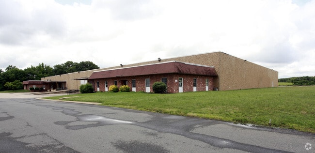
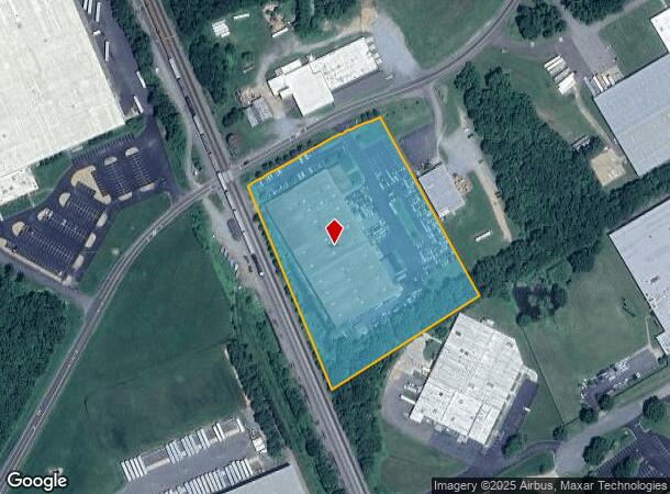
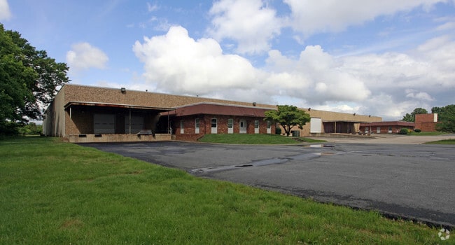
Property Record
400 Lansdowne Rd, Fredericksburg, VA 22401
NEARBY LISTINGS FOR SALE OR LEASE
Property Detail
400 Lansdowne Rd
248-P5
6.6162 AC P5 BL 248-P5 MANSFIELD S SIDE RT 638
Commercialnec
Fredericksburg
X
Virginia
51179C0214F
6.62 AC
2025
Fredericksburg City
2025
Washington, DC
000400
Washington-Arlington-Alexandria, DC-VA-MD-WV
82,875 SF
DEMOGRAPHICS near 400 Lansdowne Rd
1 Mile
3 Mile
5 Mile
2024 Total Population
3,230
48,220
114,993
2029 Population
3,538
52,340
126,431
Pop Growth 2024-2029
+ 9.54%
+ 8.54%
+ 9.95%
Average Age
38
38
38
2024 Total Households
1,158
17,872
42,659
HH Growth 2024-2029
+ 9.50%
+ 8.63%
+ 10.04%
Median Household Inc
$101,143
$99,538
$92,335
Avg Household Size
2.70
2.50
2.60
2024 Avg HH Vehicles
2.00
2.00
2.00
Median Home Value
$325,125
$364,563
$351,700
Median Year Built
1980
1989
1992
Nearby Places
Map Layers
Map Styles
 Street
 Aerial
- Restaurants
- Banks
- Shops
- Fitness
- Groceries
PUBLIC TRANSPORTATION
COMMUTER RAIL
Fredericksburg (Fredericksburg Line - Virginia Railway Express)
DRIVE
WALK
Distance
Fredericksburg (Fredericksburg Line - Virginia Railway Express)
5 min
2.1 mi
Spotsylvania (Fredericksburg Line - Virginia Railway Express)
DRIVE
WALK
Distance
Spotsylvania (Fredericksburg Line - Virginia Railway Express)
13 min
6.0 mi
Freight Ports
Virginia Port Authority - Richmond
DRIVE
WALK
Distance
Virginia Port Authority - Richmond
78 min
62.0 mi
Nearby Properties
Address
Land Use
TOTAL SIZE
Lot Size
Zoning
Address
Land Use
TOTAL SIZE
Lot Size
Zoning
2,322 SF
48.46 AC
C3 - COMME
Address
Land Use
TOTAL SIZE
Lot Size
Zoning
343,471 SF
14.61 AC
CD
Address
Land Use
TOTAL SIZE
Lot Size
Zoning
201,350 SF
43.05 AC
CT
Address
Land Use
TOTAL SIZE
Lot Size
Zoning
121,832 SF
0.23 AC
R2
Address
Land Use
TOTAL SIZE
Lot Size
Zoning
421,851 SF
7.05 AC
PDMU
Address
Land Use
TOTAL SIZE
Lot Size
Zoning
198,000 SF
23.67 AC
R2
Address
Land Use
TOTAL SIZE
Lot Size
Zoning
252,616 SF
22.31 AC
R16
Address
Land Use
TOTAL SIZE
Lot Size
Zoning
80,000 SF
0.51 AC
R2
Address
Land Use
TOTAL SIZE
Lot Size
Zoning
143,003 SF
38.64 AC
R2
Address
Land Use
TOTAL SIZE
Lot Size
Zoning
105,564 SF
1.07 AC
R2
Address
Land Use
TOTAL SIZE
Lot Size
Zoning
156,241 SF
12.73 AC
R16
Address
Land Use
TOTAL SIZE
Lot Size
Zoning
100 AC
R2
Address
Land Use
TOTAL SIZE
Lot Size
Zoning
76,950 SF
0.47 AC
CD
Address
Land Use
TOTAL SIZE
Lot Size
Zoning
192,485 SF
17.39 AC
R12
Address
Land Use
TOTAL SIZE
Lot Size
Zoning
Address
Land Use
TOTAL SIZE
Lot Size
Zoning
56,004 SF
0.46 AC
R2
Address
Land Use
TOTAL SIZE
Lot Size
Zoning
26.99 AC
PDR
Address
Land Use
TOTAL SIZE
Lot Size
Zoning
Address
Land Use
TOTAL SIZE
Lot Size
Zoning
355,593 SF
39.40 AC
I1 - INDUS
Address
Land Use
TOTAL SIZE
Lot Size
Zoning
30,964 SF
68.81 AC
R2
Address
Land Use
TOTAL SIZE
Lot Size
Zoning
75,441 SF
0.27 AC
R2
Address
Land Use
TOTAL SIZE
Lot Size
Zoning
Address
Land Use
TOTAL SIZE
Lot Size
Zoning
42,093 SF
0.66 AC
R2
Address
Land Use
TOTAL SIZE
Lot Size
Zoning
77,108 SF
5.67 AC
PDMC
Address
Land Use
TOTAL SIZE
Lot Size
Zoning
164,539 SF
11.69 AC
R16
Address
Land Use
TOTAL SIZE
Lot Size
Zoning
58,812 SF
0.47 AC
R2
Address
Land Use
TOTAL SIZE
Lot Size
Zoning
58,090 SF
0.90 AC
R2
Address
Land Use
TOTAL SIZE
Lot Size
Zoning
104,060 SF
4.12 AC
PDMC
Address
Land Use
TOTAL SIZE
Lot Size
Zoning
144,924 SF
4.88 AC
R30
Address
Land Use
TOTAL SIZE
Lot Size
Zoning
The World's #1 Commercial Real Estate Marketplace
Connect with us
© 2025 CoStar Group
The information above has been obtained from sources believed reliable. While we do not doubt its accuracy we have not verified it and make no guarantee, warranty or representation about it. It is your responsibility to independently confirm its accuracy and completeness. Any projections, opinions, assumptions, or estimates used are for example only and do not represent the current or future performance of the property. The value of this transaction to you depends on tax and other factors which should be evaluated by your tax, financial, and legal advisors. You and your advisors should conduct a careful, independent investigation of the property to determine to your satisfaction the suitability of the property for your needs.