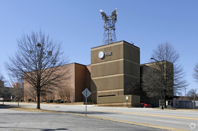
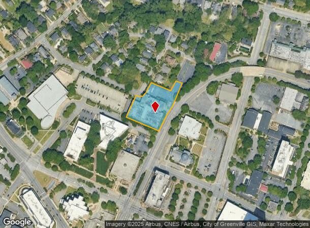
Property Record
400 N Academy St, Greenville, SC 29601


NEARBY LISTINGS FOR SALE OR LEASE
Property Detail
400 N Academy St
Greenville-Anderson-Mauldin, SC
LT 21 & PT LT 20 BARRETT ST
0012.00-01-025.00
Greenville
Radioortvstationcommunications
South Carolina
X
21
45045C0382E
1.30 AC
2025
Greenville CBD
2024
Greenville/Spartanburg
001000
DEMOGRAPHICS near 400 N Academy St
1 Mile
3 Mile
5 Mile
2024 Total Population
13,484
90,978
175,905
2029 Population
15,275
101,523
195,114
Pop Growth 2024-2029
+ 13.28%
+ 11.59%
+ 10.92%
Average Age
41
38
39
2024 Total Households
6,608
38,849
75,111
HH Growth 2024-2029
+ 13.80%
+ 11.85%
+ 11.10%
Median Household Inc
$77,167
$52,988
$54,708
Avg Household Size
1.80
2.20
2.20
2024 Avg HH Vehicles
1.00
2.00
2.00
Median Home Value
$449,319
$280,011
$254,423
Median Year Built
2003
1976
1978
Nearby Places
Map Layers
Map Styles
 Street
 Aerial
- Restaurants
- Banks
- Shops
- Fitness
- Groceries
PUBLIC TRANSPORTATION
COMMUTER RAIL
Greenville Amtrak Station (Crescent - Amtrak)
DRIVE
WALK
Distance
Greenville Amtrak Station (Crescent - Amtrak)
2 min
20 min
1.1 mi
AIRPORT
Greenville Spartanburg International
DRIVE
WALK
Distance
Greenville Spartanburg International
22 min
14.2 mi
Freight Ports
North Charleston Terminal
DRIVE
WALK
Distance
North Charleston Terminal
229 min
204.8 mi
SALE & LEASE HISTORY
LISTING DATE
SALE/LEASE

Aug 13, 2018
For Lease
Nearby Properties
Address
Land Use
TOTAL SIZE
Lot Size
Zoning
Address
Land Use
TOTAL SIZE
Lot Size
Zoning
14.21 AC
RM2
Address
Land Use
TOTAL SIZE
Lot Size
Zoning
0.45 AC
OD
Address
Land Use
TOTAL SIZE
Lot Size
Zoning
14.41 AC
RM2
Address
Land Use
TOTAL SIZE
Lot Size
Zoning
11.99 AC
RM2
Address
Land Use
TOTAL SIZE
Lot Size
Zoning
11.82 AC
RM2
Address
Land Use
TOTAL SIZE
Lot Size
Zoning
8.94 AC
RM2
Address
Land Use
TOTAL SIZE
Lot Size
Zoning
7.03 AC
OD
Address
Land Use
TOTAL SIZE
Lot Size
Zoning
1.01 AC
C4
Address
Land Use
TOTAL SIZE
Lot Size
Zoning
0.39 AC
C4
Address
Land Use
TOTAL SIZE
Lot Size
Zoning
28.88 AC
RM
Address
Land Use
TOTAL SIZE
Lot Size
Zoning
28.72 AC
C3
Address
Land Use
TOTAL SIZE
Lot Size
Zoning
0.47 AC
OD
Address
Land Use
TOTAL SIZE
Lot Size
Zoning
5.61 AC
RM2
Address
Land Use
TOTAL SIZE
Lot Size
Zoning
9.91 AC
C3
Address
Land Use
TOTAL SIZE
Lot Size
Zoning
6.17 AC
Address
Land Use
TOTAL SIZE
Lot Size
Zoning
114.75 AC
0D
Address
Land Use
TOTAL SIZE
Lot Size
Zoning
6.21 AC
C3
Address
Land Use
TOTAL SIZE
Lot Size
Zoning
1.92 AC
C4
Address
Land Use
TOTAL SIZE
Lot Size
Zoning
6.03 AC
OD
Address
Land Use
TOTAL SIZE
Lot Size
Zoning
20.04 AC
RM
Address
Land Use
TOTAL SIZE
Lot Size
Zoning
0.65 AC
OD
Address
Land Use
TOTAL SIZE
Lot Size
Zoning
0.53 AC
C4
Address
Land Use
TOTAL SIZE
Lot Size
Zoning
1.62 AC
C3
Address
Land Use
TOTAL SIZE
Lot Size
Zoning
11.13 AC
OD
Address
Land Use
TOTAL SIZE
Lot Size
Zoning
5.86 AC
RM2
Address
Land Use
TOTAL SIZE
Lot Size
Zoning
1.19 AC
C4
Address
Land Use
TOTAL SIZE
Lot Size
Zoning
47.64 AC
R6
Address
Land Use
TOTAL SIZE
Lot Size
Zoning
4.67 AC
C3
Address
Land Use
TOTAL SIZE
Lot Size
Zoning
123.10 AC
0D
Address
Land Use
TOTAL SIZE
Lot Size
Zoning
0.02 AC
C4
The World's #1 Commercial Real Estate Marketplace
Connect with us
© 2025 CoStar Group
The information above has been obtained from sources believed reliable. While we do not doubt its accuracy we have not verified it and make no guarantee, warranty or representation about it. It is your responsibility to independently confirm its accuracy and completeness. Any projections, opinions, assumptions, or estimates used are for example only and do not represent the current or future performance of the property. The value of this transaction to you depends on tax and other factors which should be evaluated by your tax, financial, and legal advisors. You and your advisors should conduct a careful, independent investigation of the property to determine to your satisfaction the suitability of the property for your needs.