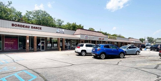
Property Record
400 N Main St, De Soto, MO 63020


Current Lease Availabilities
NEARBY LISTINGS FOR SALE OR LEASE
-
-
View all De Soto listings for lease on LoopNet.com
Property Detail
400 N Main St
St. Louis, MO-IL
Old Town
24-1.2-02.2-2-025-005
OLD TOWN; LOTS 1-24 BLK 1 & 13-19 BLK 2 &JW FLETCHERS ADD; LTS 1-9 11 12&PT 10&PT STREETS
Storebuilding
Jefferson
X
Missouri
29099C0343F
s
2024
2.61 AC
2025
Outer Jefferson Cnty
701200
St. Louis
43,938 SF
DEMOGRAPHICS near 400 N Main St
1 Mile
3 Mile
5 Mile
2024 Total Population
5,990
11,537
18,480
2029 Population
6,239
11,990
19,167
Pop Growth 2024-2029
+ 4.16%
+ 3.93%
+ 3.72%
Average Age
40
41
41
2024 Total Households
2,478
4,560
7,125
HH Growth 2024-2029
+ 4.32%
+ 4.08%
+ 3.87%
Median Household Inc
$44,294
$51,996
$57,377
Avg Household Size
2.30
2.40
2.50
2024 Avg HH Vehicles
2.00
2.00
2.00
Median Home Value
$141,427
$161,564
$181,711
Median Year Built
1970
1975
1979
Nearby Places
Map Layers
Map Styles
 Street
 Aerial
- Restaurants
- Banks
- Shops
- Fitness
- Groceries
Nearby Properties
Address
Land Use
TOTAL SIZE
Lot Size
Zoning
Address
Land Use
TOTAL SIZE
Lot Size
Zoning
161,822 SF
29.61 AC
Address
Land Use
TOTAL SIZE
Lot Size
Zoning
6.11 AC
CT1
Address
Land Use
TOTAL SIZE
Lot Size
Zoning
37,015 SF
7.33 AC
CT1
Address
Land Use
TOTAL SIZE
Lot Size
Zoning
67,041 SF
5.32 AC
CT1
Address
Land Use
TOTAL SIZE
Lot Size
Zoning
14,950 SF
2.27 AC
CT1
Address
Land Use
TOTAL SIZE
Lot Size
Zoning
71,766 SF
10.34 AC
CT1
Address
Land Use
TOTAL SIZE
Lot Size
Zoning
77,572 SF
10.74 AC
CT1
Address
Land Use
TOTAL SIZE
Lot Size
Zoning
21,532 SF
9.29 AC
Address
Land Use
TOTAL SIZE
Lot Size
Zoning
85,073 SF
6.86 AC
CT1
Address
Land Use
TOTAL SIZE
Lot Size
Zoning
44,656 SF
1.05 AC
CT1
Address
Land Use
TOTAL SIZE
Lot Size
Zoning
Address
Land Use
TOTAL SIZE
Lot Size
Zoning
10,360 SF
2.81 AC
CT1
Address
Land Use
TOTAL SIZE
Lot Size
Zoning
3,360 SF
1.17 AC
CT1
Address
Land Use
TOTAL SIZE
Lot Size
Zoning
4,505 SF
1.13 AC
Address
Land Use
TOTAL SIZE
Lot Size
Zoning
3.82 AC
CT1
Address
Land Use
TOTAL SIZE
Lot Size
Zoning
9,388 SF
0.43 AC
CT1
Address
Land Use
TOTAL SIZE
Lot Size
Zoning
3,278 SF
1.44 AC
CT1
Address
Land Use
TOTAL SIZE
Lot Size
Zoning
52,344 SF
10.40 AC
CC2
Address
Land Use
TOTAL SIZE
Lot Size
Zoning
1.36 AC
Address
Land Use
TOTAL SIZE
Lot Size
Zoning
4,891 SF
0.78 AC
CT1
Address
Land Use
TOTAL SIZE
Lot Size
Zoning
9,500 SF
1.57 AC
CT1
Address
Land Use
TOTAL SIZE
Lot Size
Zoning
2,110 SF
0.95 AC
CT1
Address
Land Use
TOTAL SIZE
Lot Size
Zoning
17,203 SF
5.29 AC
CT1
Address
Land Use
TOTAL SIZE
Lot Size
Zoning
6,816 SF
1.09 AC
Address
Land Use
TOTAL SIZE
Lot Size
Zoning
3,940 SF
2.02 AC
CT1
Address
Land Use
TOTAL SIZE
Lot Size
Zoning
3,672 SF
1.60 AC
CT1
Address
Land Use
TOTAL SIZE
Lot Size
Zoning
36,030 SF
2.27 AC
CT1
Address
Land Use
TOTAL SIZE
Lot Size
Zoning
31,132 SF
20 AC
CC2
Address
Land Use
TOTAL SIZE
Lot Size
Zoning
31,968 SF
8.36 AC
CC2
The World's #1 Commercial Real Estate Marketplace
Connect with us
© 2025 CoStar Group
The information above has been obtained from sources believed reliable. While we do not doubt its accuracy we have not verified it and make no guarantee, warranty or representation about it. It is your responsibility to independently confirm its accuracy and completeness. Any projections, opinions, assumptions, or estimates used are for example only and do not represent the current or future performance of the property. The value of this transaction to you depends on tax and other factors which should be evaluated by your tax, financial, and legal advisors. You and your advisors should conduct a careful, independent investigation of the property to determine to your satisfaction the suitability of the property for your needs.