Property Record
400 N Walker Ave, Oklahoma City, OK 73102


NEARBY LISTINGS FOR SALE OR LEASE
Property Detail
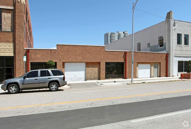
400 N Walker Ave
Oklahoma City, OK
Okla City Original
010018904
OKLA CITY ORIGINAL 066 000 LOTS 11 THRU 18 & E19.5FT LOT 19 & E5.11FT LOT 21 & ALL LOTS 22 23 & 24 PLUS PT OF VACATED ALLEY DESCRIBED AS BEG NE/C LT 11 TH N20FT W230.11FT S20FT E230.11FT TO BEG
Officebuilding
Oklahoma
X
Oklahoma
40109C0282J
11-19
2023
2.17 AC
2024
CBD
103200
Oklahoma City
63,537 SF
DEMOGRAPHICS near 400 N Walker Ave
1 Mile
3 Mile
5 Mile
2024 Total Population
9,438
82,026
218,952
2029 Population
9,833
85,418
226,014
Pop Growth 2024-2029
+ 4.19%
+ 4.14%
+ 3.23%
Average Age
36
36
36
2024 Total Households
5,280
35,418
88,317
HH Growth 2024-2029
+ 4.30%
+ 4.22%
+ 3.33%
Median Household Inc
$58,700
$43,444
$44,029
Avg Household Size
1.60
2.20
2.40
2024 Avg HH Vehicles
1.00
2.00
2.00
Median Home Value
$293,518
$143,139
$111,532
Median Year Built
2001
1950
1957
Nearby Places
Map Layers
Map Styles
 Street
 Aerial
- Restaurants
- Banks
- Shops
- Fitness
- Groceries
PUBLIC TRANSPORTATION
TRANSIT/SUBWAY
Transit Center (Downtown Loop - EMBARK, Dowtown - EMBARK)
DRIVE
WALK
Distance
Transit Center (Downtown Loop - EMBARK, Dowtown - EMBARK)
0 min
2 min
0.1 mi
Library (Downtown Loop - EMBARK, Dowtown - EMBARK)
DRIVE
WALK
Distance
Library (Downtown Loop - EMBARK, Dowtown - EMBARK)
0 min
4 min
0.2 mi
Federal Courthouse (Downtown Loop - EMBARK, Dowtown - EMBARK)
DRIVE
WALK
Distance
Federal Courthouse (Downtown Loop - EMBARK, Dowtown - EMBARK)
1 min
6 min
0.3 mi
Memorial Museum (Dowtown - EMBARK)
DRIVE
WALK
Distance
Memorial Museum (Dowtown - EMBARK)
1 min
8 min
0.4 mi
Memorial Museum (Downtown Loop - EMBARK)
DRIVE
WALK
Distance
Memorial Museum (Downtown Loop - EMBARK)
1 min
8 min
0.4 mi
COMMUTER RAIL
Oklahoma City (Heartland Flyer - Amtrak)
DRIVE
WALK
Distance
Oklahoma City (Heartland Flyer - Amtrak)
2 min
15 min
0.8 mi
AIRPORT
Will Rogers World
DRIVE
WALK
Distance
Will Rogers World
21 min
10.1 mi
Freight Ports
Tulsa Port Of Catoosa
DRIVE
WALK
Distance
Tulsa Port Of Catoosa
136 min
124.2 mi
Nearby Properties
Address
Land Use
TOTAL SIZE
Lot Size
Zoning
Address
Land Use
TOTAL SIZE
Lot Size
Zoning
3,029,769 SF
7.21 AC
DBD
Address
Land Use
TOTAL SIZE
Lot Size
Zoning
187,346 SF
13.75 AC
PUD
Address
Land Use
TOTAL SIZE
Lot Size
Zoning
1,376,216 SF
3.22 AC
DBD
Address
Land Use
TOTAL SIZE
Lot Size
Zoning
52,331 SF
2.72 AC
DBD
Address
Land Use
TOTAL SIZE
Lot Size
Zoning
324,688 SF
1.36 AC
DBD
Address
Land Use
TOTAL SIZE
Lot Size
Zoning
101,216 SF
1.23 AC
Address
Land Use
TOTAL SIZE
Lot Size
Zoning
951,493 SF
2.24 AC
DBD
Address
Land Use
TOTAL SIZE
Lot Size
Zoning
628,486 SF
0.53 AC
DBD
Address
Land Use
TOTAL SIZE
Lot Size
Zoning
511,817 SF
3.85 AC
DBD
Address
Land Use
TOTAL SIZE
Lot Size
Zoning
40,914 SF
0.50 AC
DTD-1
Address
Land Use
TOTAL SIZE
Lot Size
Zoning
417,965 SF
3.48 AC
DTD-1
Address
Land Use
TOTAL SIZE
Lot Size
Zoning
413,783 SF
6.25 AC
DBD
Address
Land Use
TOTAL SIZE
Lot Size
Zoning
194,762 SF
3 AC
DTD-1
Address
Land Use
TOTAL SIZE
Lot Size
Zoning
91,352 SF
0.68 AC
DBD
Address
Land Use
TOTAL SIZE
Lot Size
Zoning
303,589 SF
7.17 AC
PUD
Address
Land Use
TOTAL SIZE
Lot Size
Zoning
382,618 SF
5.13 AC
BC
Address
Land Use
TOTAL SIZE
Lot Size
Zoning
164,861 SF
0.32 AC
Address
Land Use
TOTAL SIZE
Lot Size
Zoning
2.59 AC
DBD
Address
Land Use
TOTAL SIZE
Lot Size
Zoning
38,866 SF
2.89 AC
DBD
Address
Land Use
TOTAL SIZE
Lot Size
Zoning
307,772 SF
1.32 AC
DBD
Address
Land Use
TOTAL SIZE
Lot Size
Zoning
281,052 SF
1.89 AC
DBD
Address
Land Use
TOTAL SIZE
Lot Size
Zoning
42,450 SF
0.32 AC
BC
Address
Land Use
TOTAL SIZE
Lot Size
Zoning
302,236 SF
2.62 AC
SPUD
Address
Land Use
TOTAL SIZE
Lot Size
Zoning
279,464 SF
1.49 AC
DBD
Address
Land Use
TOTAL SIZE
Lot Size
Zoning
188,121 SF
0.83 AC
BC
Address
Land Use
TOTAL SIZE
Lot Size
Zoning
344,045 SF
0.55 AC
DBD
Address
Land Use
TOTAL SIZE
Lot Size
Zoning
246,881 SF
1.10 AC
DBD
Address
Land Use
TOTAL SIZE
Lot Size
Zoning
26,340 SF
2.38 AC
NC
Address
Land Use
TOTAL SIZE
Lot Size
Zoning
502,508 SF
2.27 AC
DBD
Address
Land Use
TOTAL SIZE
Lot Size
Zoning
184,398 SF
8.09 AC
PUD
The World's #1 Commercial Real Estate Marketplace
Connect with us
© 2025 CoStar Group
The information above has been obtained from sources believed reliable. While we do not doubt its accuracy we have not verified it and make no guarantee, warranty or representation about it. It is your responsibility to independently confirm its accuracy and completeness. Any projections, opinions, assumptions, or estimates used are for example only and do not represent the current or future performance of the property. The value of this transaction to you depends on tax and other factors which should be evaluated by your tax, financial, and legal advisors. You and your advisors should conduct a careful, independent investigation of the property to determine to your satisfaction the suitability of the property for your needs.