Property Record
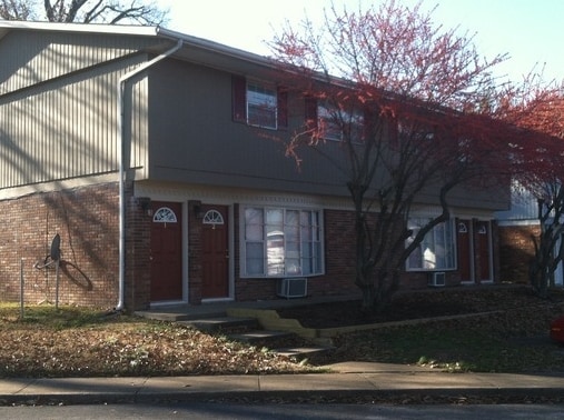
400 N Westridge Dr, Carbondale, IL 62901


NEARBY LISTINGS FOR SALE OR LEASE
Property Detail
400 N Westridge Dr
15-18-451-049
Westridge
Commercialofficeresidentialmixeduse
DEVELOPMENT TRACT A-1, A-3, A-4,A-5 WESTRIDGE PT SW 18-9-1 .0584 AC 392/437 721/884 410/280 938/319 1034/419 2013/17072 2023R
X
Jackson
17077C0335D
Illinois
2024
0.06 AC
2024
Marion/I-64 & South
011001
Other Market Areas
4,000 SF
Carbondale, IL
DEMOGRAPHICS near 400 N Westridge Dr
1 Mile
3 Mile
5 Mile
2024 Total Population
2,972
19,498
31,152
2029 Population
2,940
19,506
31,069
Pop Growth 2024-2029
(1.08%)
+ 0.04%
(0.27%)
Average Age
46
36
36
2024 Total Households
1,364
8,373
13,858
HH Growth 2024-2029
(1.25%)
+ 0.18%
(0.30%)
Median Household Inc
$73,618
$33,061
$32,207
Avg Household Size
2.00
1.90
2.00
2024 Avg HH Vehicles
2.00
1.00
1.00
Median Home Value
$186,630
$140,700
$139,632
Median Year Built
1984
1977
1978
Nearby Places
Map Layers
Map Styles
 Street
 Aerial
- Restaurants
- Banks
- Shops
- Fitness
- Groceries
PUBLIC TRANSPORTATION
COMMUTER RAIL
DRIVE
WALK
Distance
6 min
2.6 mi
SALE & LEASE HISTORY
LISTING DATE
SALE/LEASE

Nov 10, 2022
For Sale
Mar 25, 2019
For Sale
Nearby Properties
Address
Land Use
TOTAL SIZE
Lot Size
Zoning
Address
Land Use
TOTAL SIZE
Lot Size
Zoning
Address
Land Use
TOTAL SIZE
Lot Size
Zoning
16.78 AC
Address
Land Use
TOTAL SIZE
Lot Size
Zoning
9,360 SF
1.56 AC
Address
Land Use
TOTAL SIZE
Lot Size
Zoning
Address
Land Use
TOTAL SIZE
Lot Size
Zoning
10.15 AC
Address
Land Use
TOTAL SIZE
Lot Size
Zoning
13,440 SF
0.83 AC
Address
Land Use
TOTAL SIZE
Lot Size
Zoning
1.21 AC
Address
Land Use
TOTAL SIZE
Lot Size
Zoning
3,072 SF
1.89 AC
Address
Land Use
TOTAL SIZE
Lot Size
Zoning
0.85 AC
Address
Land Use
TOTAL SIZE
Lot Size
Zoning
0.35 AC
Address
Land Use
TOTAL SIZE
Lot Size
Zoning
Address
Land Use
TOTAL SIZE
Lot Size
Zoning
2.03 AC
Address
Land Use
TOTAL SIZE
Lot Size
Zoning
0.71 AC
Address
Land Use
TOTAL SIZE
Lot Size
Zoning
4.25 AC
Address
Land Use
TOTAL SIZE
Lot Size
Zoning
3,789 SF
9.68 AC
Address
Land Use
TOTAL SIZE
Lot Size
Zoning
1.35 AC
Address
Land Use
TOTAL SIZE
Lot Size
Zoning
Address
Land Use
TOTAL SIZE
Lot Size
Zoning
2.46 AC
Address
Land Use
TOTAL SIZE
Lot Size
Zoning
12,909 SF
0.62 AC
Address
Land Use
TOTAL SIZE
Lot Size
Zoning
Address
Land Use
TOTAL SIZE
Lot Size
Zoning
7,104 SF
1.76 AC
Address
Land Use
TOTAL SIZE
Lot Size
Zoning
11,284 SF
0.67 AC
Address
Land Use
TOTAL SIZE
Lot Size
Zoning
48,243 SF
10 AC
Address
Land Use
TOTAL SIZE
Lot Size
Zoning
7,140 SF
6 AC
Address
Land Use
TOTAL SIZE
Lot Size
Zoning
The World's #1 Commercial Real Estate Marketplace
Connect with us
© 2026 CoStar Group
The information above has been obtained from sources believed reliable. While we do not doubt its accuracy we have not verified it and make no guarantee, warranty or representation about it. It is your responsibility to independently confirm its accuracy and completeness. Any projections, opinions, assumptions, or estimates used are for example only and do not represent the current or future performance of the property. The value of this transaction to you depends on tax and other factors which should be evaluated by your tax, financial, and legal advisors. You and your advisors should conduct a careful, independent investigation of the property to determine to your satisfaction the suitability of the property for your needs.