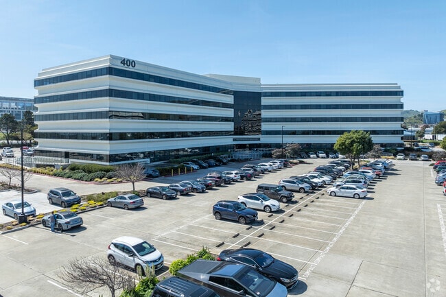
Property Record
400 Oyster Point Blvd, South San Francisco, CA 94080

Current Lease Availabilities
NEARBY LISTINGS FOR SALE OR LEASE
Property Detail
400 Oyster Point Blvd
015-011-030
10.4959 AC MOL PARCEL 3 OF PM VOL 52/58-59
Officebuilding
San Mateo
AE
California
06081C0042F
3
2024
10.50 AC
2025
South San Francisco
602300
San Francisco
226,702 SF
San Francisco-Redwood City-South San Francisco, CA
DEMOGRAPHICS near 400 Oyster Point Blvd
1 Mile
3 Mile
5 Mile
2024 Total Population
183
42,049
265,796
2029 Population
180
39,989
247,370
Pop Growth 2024-2029
(1.64%)
(4.90%)
(6.93%)
Average Age
41
41
42
2024 Total Households
52
13,657
83,965
HH Growth 2024-2029
(1.92%)
(5.17%)
(7.09%)
Median Household Inc
$143,749
$99,786
$106,411
Avg Household Size
3.30
3.00
3.00
2024 Avg HH Vehicles
3.00
2.00
2.00
Median Home Value
$1,078,000
$1,038,177
$1,036,905
Median Year Built
1972
1962
1962
Nearby Places
Map Layers
Map Styles
 Street
 Aerial
- Restaurants
- Banks
- Shops
- Fitness
- Groceries
PUBLIC TRANSPORTATION
COMMUTER RAIL
South San Francisco (Caltrain - Caltrain (Caltrain))
DRIVE
WALK
Distance
South San Francisco (Caltrain - Caltrain (Caltrain))
5 min
2.1 mi
DRIVE
WALK
Distance
9 min
4.3 mi
AIRPORT
San Francisco International
DRIVE
WALK
Distance
San Francisco International
13 min
5.9 mi
Metro Oakland International
DRIVE
WALK
Distance
Metro Oakland International
44 min
28.7 mi
Norman Y Mineta San Jose International
DRIVE
WALK
Distance
Norman Y Mineta San Jose International
48 min
37.5 mi
Nearby Properties
Address
Land Use
TOTAL SIZE
Lot Size
Zoning
Address
Land Use
TOTAL SIZE
Lot Size
Zoning
780,375 SF
23.23 AC
Address
Land Use
TOTAL SIZE
Lot Size
Zoning
Address
Land Use
TOTAL SIZE
Lot Size
Zoning
2,008 SF
16.83 AC
Address
Land Use
TOTAL SIZE
Lot Size
Zoning
574,675 SF
10.07 AC
Address
Land Use
TOTAL SIZE
Lot Size
Zoning
8.97 AC
OA0000
Address
Land Use
TOTAL SIZE
Lot Size
Zoning
Address
Land Use
TOTAL SIZE
Lot Size
Zoning
350,036 SF
2.91 AC
Address
Land Use
TOTAL SIZE
Lot Size
Zoning
323,091 SF
14.83 AC
Address
Land Use
TOTAL SIZE
Lot Size
Zoning
Address
Land Use
TOTAL SIZE
Lot Size
Zoning
24,070 SF
6.44 AC
M2000H
Address
Land Use
TOTAL SIZE
Lot Size
Zoning
529,342 SF
5.28 AC
Address
Land Use
TOTAL SIZE
Lot Size
Zoning
161,850 SF
7.48 AC
Address
Land Use
TOTAL SIZE
Lot Size
Zoning
4,047 SF
4.25 AC
Address
Land Use
TOTAL SIZE
Lot Size
Zoning
293,445 SF
6.70 AC
MH00M2
Address
Land Use
TOTAL SIZE
Lot Size
Zoning
528,605 SF
17.06 AC
M2000H
Address
Land Use
TOTAL SIZE
Lot Size
Zoning
Address
Land Use
TOTAL SIZE
Lot Size
Zoning
152,145 SF
6.10 AC
MH00M2
Address
Land Use
TOTAL SIZE
Lot Size
Zoning
Address
Land Use
TOTAL SIZE
Lot Size
Zoning
176,096 SF
2.74 AC
Address
Land Use
TOTAL SIZE
Lot Size
Zoning
2,016 SF
3.61 AC
Address
Land Use
TOTAL SIZE
Lot Size
Zoning
2,007 SF
7.66 AC
Address
Land Use
TOTAL SIZE
Lot Size
Zoning
112,912 SF
5.96 AC
MH00M2
Address
Land Use
TOTAL SIZE
Lot Size
Zoning
254,775 SF
17.01 AC
Address
Land Use
TOTAL SIZE
Lot Size
Zoning
126,971 SF
3.04 AC
Address
Land Use
TOTAL SIZE
Lot Size
Zoning
Address
Land Use
TOTAL SIZE
Lot Size
Zoning
107,773 SF
6.73 AC
M20000
Address
Land Use
TOTAL SIZE
Lot Size
Zoning
1,282,685 SF
21.15 AC
Address
Land Use
TOTAL SIZE
Lot Size
Zoning
2,008 SF
8.84 AC
Address
Land Use
TOTAL SIZE
Lot Size
Zoning
141,360 SF
8.56 AC
Address
Land Use
TOTAL SIZE
Lot Size
Zoning
141,677 SF
8.57 AC
The World's #1 Commercial Real Estate Marketplace
Connect with us
© 2026 CoStar Group
The information above has been obtained from sources believed reliable. While we do not doubt its accuracy we have not verified it and make no guarantee, warranty or representation about it. It is your responsibility to independently confirm its accuracy and completeness. Any projections, opinions, assumptions, or estimates used are for example only and do not represent the current or future performance of the property. The value of this transaction to you depends on tax and other factors which should be evaluated by your tax, financial, and legal advisors. You and your advisors should conduct a careful, independent investigation of the property to determine to your satisfaction the suitability of the property for your needs.