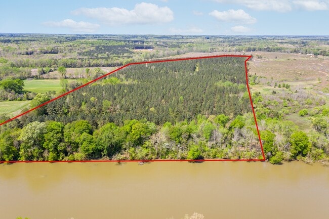
Property Record
400 Rowells Rd, Catawba, SC 29704
NEARBY LISTINGS FOR SALE OR LEASE
-
-
View all Catawba listings for sale on LoopNet.com
Property Detail
400 Rowells Rd
7580000025
Al
Residentialnec
(1.10 AC) ROWELL ROAD
X
York
45023C0110D
South Carolina
2025
8.12 AC
2025
York County
061203
Charlotte
13,913 SF
Charlotte-Concord-Gastonia, NC-SC
DEMOGRAPHICS near 400 Rowells Rd
1 mile
3 mile
5 mile
2024 Total Population
647
5,300
14,577
2029 Population
729
5,970
16,491
Pop Growth 2024-2029
+ 12.67%
+ 12.64%
+ 13.13%
Average Age
43
43
43
2024 Total Households
249
2,032
5,567
HH Growth 2024-2029
+ 13.25%
+ 12.94%
+ 13.49%
Median Household Inc
$58,382
$58,045
$61,939
Avg Household Size
2.60
2.60
2.60
2024 Avg HH Vehicles
3.00
2.00
2.00
Median Home Value
$220,000
$229,223
$236,769
Median Year Built
1992
1993
1993
Nearby Places
Map Layers
Map Styles
 Street
 Aerial
Transit
 Traffic
 Biking
Places
Listings with unknown addresses are not visible on the map
- Restaurants
- Banks
- Shops
- Fitness
- Groceries
PUBLIC TRANSPORTATION
AIRPORT
Charlotte/Douglas International
Drive
Walk
Distance
Charlotte/Douglas International
48 min
30.8 mi
Freight Ports
North Charleston Terminal
Drive
Walk
Distance
North Charleston Terminal
206 min
182.4 mi
SALE & LEASE HISTORY
LISTING DATE
SALE/LEASE

Jul 13, 2021
For Sale
Nearby Properties
Address
Land Use
TOTAL SIZE
Lot Size
Zoning
Address
Land Use
TOTAL SIZE
Lot Size
Zoning
781.29 AC
ID
Address
Land Use
TOTAL SIZE
Lot Size
Zoning
117,546 SF
44.67 AC
ID
Address
Land Use
TOTAL SIZE
Lot Size
Zoning
166.80 AC
RN
Address
Land Use
TOTAL SIZE
Lot Size
Zoning
144.93 AC
RN
Address
Land Use
TOTAL SIZE
Lot Size
Zoning
2,495 SF
1 AC
PD
Address
Land Use
TOTAL SIZE
Lot Size
Zoning
2,042 SF
1 AC
RUD
Address
Land Use
TOTAL SIZE
Lot Size
Zoning
2,269 SF
1 AC
PD
Address
Land Use
TOTAL SIZE
Lot Size
Zoning
2,368 SF
1 AC
RCI
Address
Land Use
TOTAL SIZE
Lot Size
Zoning
1,735 SF
1 AC
PD
Address
Land Use
TOTAL SIZE
Lot Size
Zoning
27.89 AC
RDI
Address
Land Use
TOTAL SIZE
Lot Size
Zoning
2,112 SF
3.34 AC
Address
Land Use
TOTAL SIZE
Lot Size
Zoning
1,944 SF
1 AC
RUD
Address
Land Use
TOTAL SIZE
Lot Size
Zoning
1,404 SF
1.73 AC
RUD
Address
Land Use
TOTAL SIZE
Lot Size
Zoning
1,836 SF
1 AC
RUD
Address
Land Use
TOTAL SIZE
Lot Size
Zoning
2,243 SF
1 AC
RCI
Address
Land Use
TOTAL SIZE
Lot Size
Zoning
1,566 SF
1 AC
RCI
Address
Land Use
TOTAL SIZE
Lot Size
Zoning
32,572 SF
20.60 AC
HI
Address
Land Use
TOTAL SIZE
Lot Size
Zoning
1,486 SF
1 AC
RCI
Address
Land Use
TOTAL SIZE
Lot Size
Zoning
1,784 SF
1.59 AC
RUD
Address
Land Use
TOTAL SIZE
Lot Size
Zoning
1,400 SF
2.52 AC
RUD
Address
Land Use
TOTAL SIZE
Lot Size
Zoning
1,578 SF
0.95 AC
RCI
Address
Land Use
TOTAL SIZE
Lot Size
Zoning
12.41 AC
RCI
Address
Land Use
TOTAL SIZE
Lot Size
Zoning
1,200 SF
0.72 AC
RCI
Address
Land Use
TOTAL SIZE
Lot Size
Zoning
18.69 AC
ID
Address
Land Use
TOTAL SIZE
Lot Size
Zoning
1,434 SF
251.42 AC
RN
Address
Land Use
TOTAL SIZE
Lot Size
Zoning
14.42 AC
ID
Address
Land Use
TOTAL SIZE
Lot Size
Zoning
6.34 AC
RCI
Address
Land Use
TOTAL SIZE
Lot Size
Zoning
10.08 AC
LI
Address
Land Use
TOTAL SIZE
Lot Size
Zoning
12.19 AC
RUD
Address
Land Use
TOTAL SIZE
Lot Size
Zoning
6 AC
RCI
The World's #1 Commercial Real Estate Marketplace
Connect with us
© 2026 CoStar Group
The information above has been obtained from sources believed reliable. While we do not doubt its accuracy we have not verified it and make no guarantee, warranty or representation about it. It is your responsibility to independently confirm its accuracy and completeness. Any projections, opinions, assumptions, or estimates used are for example only and do not represent the current or future performance of the property. The value of this transaction to you depends on tax and other factors which should be evaluated by your tax, financial, and legal advisors. You and your advisors should conduct a careful, independent investigation of the property to determine to your satisfaction the suitability of the property for your needs.