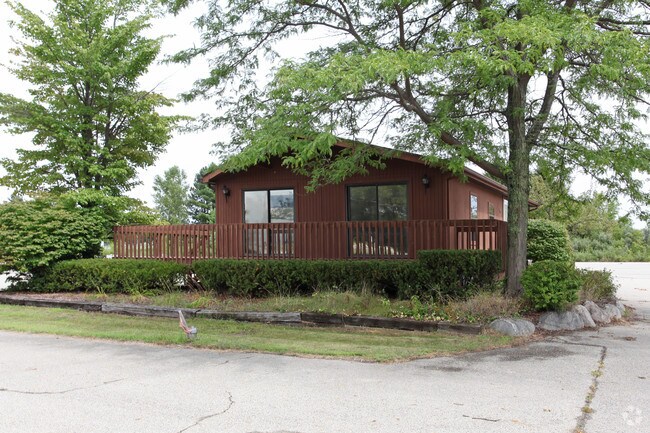
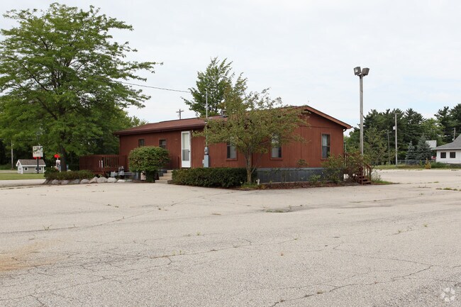
Property Record
400 S Main St, Cedar Springs, MI 49319
NEARBY LISTINGS FOR SALE OR LEASE
-
-
View all Cedar Springs listings for sale on LoopNet.com
Property Detail
400 S Main St
41-03-31-101-024
PART OF NW 1/4 COM 35.0 FT N ALONG E LINE OF W 350 FT OF NWFRL 1/4 FROM N LINE OF S 315 FT OF NWFRL 1/4 NWFRL 1/4 TH S ALONG
Commercialnec
Kent
X
Michigan
26081C0185D
2.93 AC
2024
Outlying Kent County
2025
West Michigan
010200
Grand Rapids-Wyoming, MI
4,632 SF
DEMOGRAPHICS near 400 S Main St
1 Mile
3 Mile
5 Mile
2024 Total Population
3,662
10,316
21,327
2029 Population
3,706
10,445
21,591
Pop Growth 2024-2029
+ 1.20%
+ 1.25%
+ 1.24%
Average Age
36
39
39
2024 Total Households
1,303
3,716
7,607
HH Growth 2024-2029
+ 1.30%
+ 1.29%
+ 1.25%
Median Household Inc
$52,097
$71,062
$84,000
Avg Household Size
2.70
2.70
2.80
2024 Avg HH Vehicles
2.00
2.00
2.00
Median Home Value
$204,675
$235,214
$249,964
Median Year Built
1969
1989
1992
Nearby Places
Map Layers
Map Styles
 Street
 Aerial
- Restaurants
- Banks
- Shops
- Fitness
- Groceries
PUBLIC TRANSPORTATION
AIRPORT
Gerald R Ford International
DRIVE
WALK
Distance
Gerald R Ford International
43 min
28.5 mi
Nearby Properties
Address
Land Use
TOTAL SIZE
Lot Size
Zoning
Address
Land Use
TOTAL SIZE
Lot Size
Zoning
435,600 SF
Address
Land Use
TOTAL SIZE
Lot Size
Zoning
413,330 SF
20.83 AC
I-1
Address
Land Use
TOTAL SIZE
Lot Size
Zoning
40,800 SF
109.96 AC
IC
Address
Land Use
TOTAL SIZE
Lot Size
Zoning
Address
Land Use
TOTAL SIZE
Lot Size
Zoning
48,220 SF
4.09 AC
Address
Land Use
TOTAL SIZE
Lot Size
Zoning
13,955 SF
196.11 AC
MHP
Address
Land Use
TOTAL SIZE
Lot Size
Zoning
3,160 SF
37.37 AC
R-4
Address
Land Use
TOTAL SIZE
Lot Size
Zoning
111,520 SF
7.30 AC
I-1
Address
Land Use
TOTAL SIZE
Lot Size
Zoning
14,170 SF
4.50 AC
H-C
Address
Land Use
TOTAL SIZE
Lot Size
Zoning
3,400 SF
8.59 AC
C2
Address
Land Use
TOTAL SIZE
Lot Size
Zoning
36,324 SF
8.29 AC
C2
Address
Land Use
TOTAL SIZE
Lot Size
Zoning
8.86 AC
C2
Address
Land Use
TOTAL SIZE
Lot Size
Zoning
Address
Land Use
TOTAL SIZE
Lot Size
Zoning
55,224 SF
5.87 AC
R-3
Address
Land Use
TOTAL SIZE
Lot Size
Zoning
61,816 SF
5.10 AC
H-C
Address
Land Use
TOTAL SIZE
Lot Size
Zoning
5,816 SF
10.46 AC
HC
Address
Land Use
TOTAL SIZE
Lot Size
Zoning
50,610 SF
6.47 AC
H-C
Address
Land Use
TOTAL SIZE
Lot Size
Zoning
20 AC
MHP
Address
Land Use
TOTAL SIZE
Lot Size
Zoning
3.56 AC
C2
Address
Land Use
TOTAL SIZE
Lot Size
Zoning
1,800 SF
75 AC
MHP
Address
Land Use
TOTAL SIZE
Lot Size
Zoning
3,056 SF
3.27 AC
HC
Address
Land Use
TOTAL SIZE
Lot Size
Zoning
38,473 SF
8.61 AC
R-3
Address
Land Use
TOTAL SIZE
Lot Size
Zoning
24,800 SF
3.90 AC
Address
Land Use
TOTAL SIZE
Lot Size
Zoning
16,000 SF
9.83 AC
Address
Land Use
TOTAL SIZE
Lot Size
Zoning
572 SF
16.47 AC
R-4
Address
Land Use
TOTAL SIZE
Lot Size
Zoning
Address
Land Use
TOTAL SIZE
Lot Size
Zoning
8,684 SF
3.54 AC
Address
Land Use
TOTAL SIZE
Lot Size
Zoning
14,653 SF
1.80 AC
H-C
Address
Land Use
TOTAL SIZE
Lot Size
Zoning
Address
Land Use
TOTAL SIZE
Lot Size
Zoning
13,520 SF
The World's #1 Commercial Real Estate Marketplace
Connect with us
© 2025 CoStar Group
The information above has been obtained from sources believed reliable. While we do not doubt its accuracy we have not verified it and make no guarantee, warranty or representation about it. It is your responsibility to independently confirm its accuracy and completeness. Any projections, opinions, assumptions, or estimates used are for example only and do not represent the current or future performance of the property. The value of this transaction to you depends on tax and other factors which should be evaluated by your tax, financial, and legal advisors. You and your advisors should conduct a careful, independent investigation of the property to determine to your satisfaction the suitability of the property for your needs.