Property Record
400 S Main St, Terryville, CT 06786
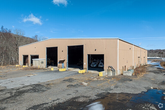


This Property Is For Sale
Current Lease Availabilities
Property Detail
400 S Main St
Torrington, CT
LITCHFIELD
PLYM-000069-000107-000016A
Connecticut
Commercialnec
16a
M
7.53 AC
2025
SE Litchfield County
2025
Hartford
425400
NEARBY LISTINGS FOR SALE OR LEASE
DEMOGRAPHICS near 400 S Main St
1 mile
3 mile
5 mile
2025 Total Population
1,033
22,886
73,082
2030 Population
1,064
23,539
75,095
Pop Growth 2025-2030
+ 3.00%
+ 2.85%
+ 2.75%
Average Age
43
42
42
2025 Total Households
429
9,323
29,794
HH Growth 2025-2030
+ 2.80%
+ 2.78%
+ 2.75%
Median Household Inc
$96,944
$92,834
$86,501
Avg Household Size
2.40
2.40
2.40
2025 Avg HH Vehicles
2.00
2.00
2.00
Median Home Value
$269,551
$277,558
$283,805
Median Year Built
1969
1970
1968
Nearby Places
Map Layers
Map Styles
 Street
 Aerial
Layers
 Traffic
 Biking
Places
Listings with unknown addresses are not visible on the map
- Restaurants
- Banks
- Shops
- Fitness
- Groceries
PUBLIC TRANSPORTATION
COMMUTER RAIL
Waterbury Station (New Haven Line - Metro-North Commuter Railroad Company (Metro-North))
Drive
Walk
Distance
Waterbury Station (New Haven Line - Metro-North Commuter Railroad Company (Metro-North))
20 min
9.3 mi
AIRPORT
Bradley International
Drive
Walk
Distance
Bradley International
63 min
35.5 mi
Tweed/New Haven
Drive
Walk
Distance
Tweed/New Haven
56 min
36.8 mi
Nearby Properties
Address
Land Use
TOTAL SIZE
Lot Size
Zoning
Address
Land Use
TOTAL SIZE
Lot Size
Zoning
121,917 SF
28.60 AC
R-15
Address
Land Use
TOTAL SIZE
Lot Size
Zoning
171,826 SF
36.60 AC
R-15
Address
Land Use
TOTAL SIZE
Lot Size
Zoning
3.35 AC
RA2
Address
Land Use
TOTAL SIZE
Lot Size
Zoning
63,101 SF
15.50 AC
R-25
Address
Land Use
TOTAL SIZE
Lot Size
Zoning
45,377 SF
91.90 AC
R-40
Address
Land Use
TOTAL SIZE
Lot Size
Zoning
49,977 SF
15.56 AC
R-25
Address
Land Use
TOTAL SIZE
Lot Size
Zoning
205,964 SF
14.35 AC
IP-3
Address
Land Use
TOTAL SIZE
Lot Size
Zoning
27,216 SF
3.80 AC
R-15/R
Address
Land Use
TOTAL SIZE
Lot Size
Zoning
2,464 SF
104.60 AC
R-40
Address
Land Use
TOTAL SIZE
Lot Size
Zoning
34.36 AC
RA2
Address
Land Use
TOTAL SIZE
Lot Size
Zoning
10 AC
RA1
Address
Land Use
TOTAL SIZE
Lot Size
Zoning
2.77 AC
C
Address
Land Use
TOTAL SIZE
Lot Size
Zoning
3.99 AC
RA1
Address
Land Use
TOTAL SIZE
Lot Size
Zoning
99,750 SF
9.10 AC
IP-3
Address
Land Use
TOTAL SIZE
Lot Size
Zoning
22,938 SF
1.92 AC
M
Address
Land Use
TOTAL SIZE
Lot Size
Zoning
508.90 AC
RA1
Address
Land Use
TOTAL SIZE
Lot Size
Zoning
4.30 AC
RA2
Address
Land Use
TOTAL SIZE
Lot Size
Zoning
1,703 SF
119.10 AC
R-40
Address
Land Use
TOTAL SIZE
Lot Size
Zoning
4,366 SF
4.90 AC
R-15
Address
Land Use
TOTAL SIZE
Lot Size
Zoning
94,414 SF
6.50 AC
M
Address
Land Use
TOTAL SIZE
Lot Size
Zoning
11.25 AC
RA2
Address
Land Use
TOTAL SIZE
Lot Size
Zoning
1.82 AC
R-25
Address
Land Use
TOTAL SIZE
Lot Size
Zoning
53,240 SF
8.40 AC
IP-3
Address
Land Use
TOTAL SIZE
Lot Size
Zoning
49,690 SF
3.59 AC
M
Address
Land Use
TOTAL SIZE
Lot Size
Zoning
1,720 SF
2.64 AC
R-15
Address
Land Use
TOTAL SIZE
Lot Size
Zoning
2.22 AC
M
Address
Land Use
TOTAL SIZE
Lot Size
Zoning
2.10 AC
C
Address
Land Use
TOTAL SIZE
Lot Size
Zoning
7.03 AC
C
Address
Land Use
TOTAL SIZE
Lot Size
Zoning
6.10 AC
M
Address
Land Use
TOTAL SIZE
Lot Size
Zoning
3.96 AC
RA2
The World's #1 Commercial Real Estate Marketplace
Connect with us
© 2026 CoStar Group
The information above has been obtained from sources believed reliable. While we do not doubt its accuracy we have not verified it and make no guarantee, warranty or representation about it. It is your responsibility to independently confirm its accuracy and completeness. Any projections, opinions, assumptions, or estimates used are for example only and do not represent the current or future performance of the property. The value of this transaction to you depends on tax and other factors which should be evaluated by your tax, financial, and legal advisors. You and your advisors should conduct a careful, independent investigation of the property to determine to your satisfaction the suitability of the property for your needs.