Property Record
400 S Pine St, Lansing, MI 48933
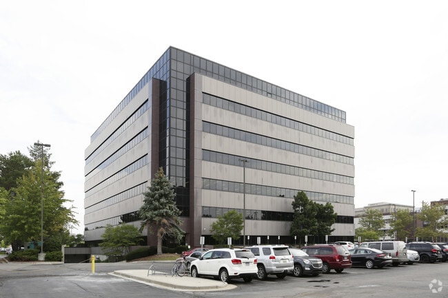

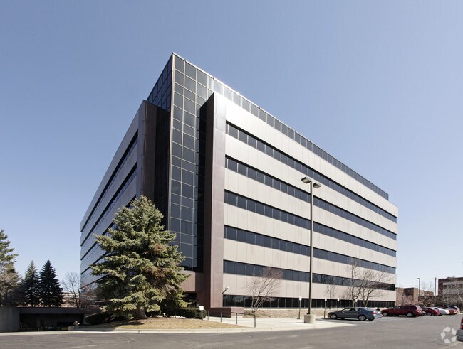
Property Detail
400 S Pine St
01-01-16-352-002
LOT 6 CAPITOL COMMONS URBAN RENEWAL PLAT NO 2
Officebuilding
Ingham
D-1 PRO
Michigan
B and X Area of moderate flood hazard, usually the area between the limits of the 100-year and 500-year floods.
6
2024
3.06 AC
2025
Central Lansing
006700
West Michigan
150,589 SF
Lansing-East Lansing, MI
NEARBY LISTINGS FOR SALE OR LEASE
DEMOGRAPHICS near 400 S Pine St
1 mile
3 mile
5 mile
2025 Total Population
11,733
85,857
193,418
2030 Population
12,180
87,422
198,085
Pop Growth 2025-2030
+ 3.81%
+ 1.82%
+ 2.41%
Average Age
37
38
36
2025 Total Households
5,806
38,538
81,396
HH Growth 2025-2030
+ 4.24%
+ 1.93%
+ 2.48%
Median Household Inc
$50,846
$54,965
$53,859
Avg Household Size
1.90
2.10
2.20
2025 Avg HH Vehicles
1.00
1.00
2.00
Median Home Value
$148,991
$139,182
$160,524
Median Year Built
1949
1954
1966
Nearby Places
Map Layers
Map Styles
 Street
 Aerial
Transit
 Traffic
 Biking
Places
Listings with unknown addresses are not visible on the map
- Restaurants
- Banks
- Shops
- Fitness
- Groceries
PUBLIC TRANSPORTATION
COMMUTER RAIL
Drive
Walk
Distance
8 min
4.1 mi
AIRPORT
Capital Region International
Drive
Walk
Distance
Capital Region International
10 min
4.3 mi
Nearby Properties
Address
Land Use
TOTAL SIZE
Lot Size
Zoning
Address
Land Use
TOTAL SIZE
Lot Size
Zoning
111,180 SF
3.63 AC
G-1 BUS
Address
Land Use
TOTAL SIZE
Lot Size
Zoning
14,304 SF
3.37 AC
MIXED Z
Address
Land Use
TOTAL SIZE
Lot Size
Zoning
63,461 SF
32 AC
F COMM
Address
Land Use
TOTAL SIZE
Lot Size
Zoning
177,300 SF
8.72 AC
Address
Land Use
TOTAL SIZE
Lot Size
Zoning
69,851 SF
134.23 AC
I HVY
Address
Land Use
TOTAL SIZE
Lot Size
Zoning
13.13 AC
Address
Land Use
TOTAL SIZE
Lot Size
Zoning
195,094 SF
1.89 AC
Address
Land Use
TOTAL SIZE
Lot Size
Zoning
2,137 SF
12.72 AC
H LT IN
Address
Land Use
TOTAL SIZE
Lot Size
Zoning
185,190 SF
0.41 AC
G-1 BUS
Address
Land Use
TOTAL SIZE
Lot Size
Zoning
131,234 SF
2.49 AC
Address
Land Use
TOTAL SIZE
Lot Size
Zoning
332,832 SF
2.48 AC
G-1 BUS
Address
Land Use
TOTAL SIZE
Lot Size
Zoning
2,276,790 SF
96.93 AC
NONE
Address
Land Use
TOTAL SIZE
Lot Size
Zoning
51,248 SF
4.85 AC
I HVY
Address
Land Use
TOTAL SIZE
Lot Size
Zoning
169,704 SF
0.67 AC
G-1 BUS
Address
Land Use
TOTAL SIZE
Lot Size
Zoning
165,684 SF
1.20 AC
G-1 BUS
Address
Land Use
TOTAL SIZE
Lot Size
Zoning
159,455 SF
0.42 AC
Address
Land Use
TOTAL SIZE
Lot Size
Zoning
157,548 SF
0.72 AC
Address
Land Use
TOTAL SIZE
Lot Size
Zoning
114,681 SF
1.08 AC
G-1 BUS
Address
Land Use
TOTAL SIZE
Lot Size
Zoning
131,040 SF
2.36 AC
Address
Land Use
TOTAL SIZE
Lot Size
Zoning
67,365 SF
4.19 AC
H LT IN
Address
Land Use
TOTAL SIZE
Lot Size
Zoning
Address
Land Use
TOTAL SIZE
Lot Size
Zoning
121,536 SF
2 AC
Address
Land Use
TOTAL SIZE
Lot Size
Zoning
76,606 SF
1.75 AC
Address
Land Use
TOTAL SIZE
Lot Size
Zoning
140,722 SF
1.40 AC
Address
Land Use
TOTAL SIZE
Lot Size
Zoning
69,768 SF
8.22 AC
D ADMIN
Address
Land Use
TOTAL SIZE
Lot Size
Zoning
14,505 SF
90 AC
Address
Land Use
TOTAL SIZE
Lot Size
Zoning
78,000 SF
0.18 AC
G-1 BUS
Address
Land Use
TOTAL SIZE
Lot Size
Zoning
101,893 SF
0.40 AC
G-1 BUS
Address
Land Use
TOTAL SIZE
Lot Size
Zoning
72,188 SF
1.45 AC
The World's #1 Commercial Real Estate Marketplace
Connect with us
© 2026 CoStar Group
The information above has been obtained from sources believed reliable. While we do not doubt its accuracy we have not verified it and make no guarantee, warranty or representation about it. It is your responsibility to independently confirm its accuracy and completeness. Any projections, opinions, assumptions, or estimates used are for example only and do not represent the current or future performance of the property. The value of this transaction to you depends on tax and other factors which should be evaluated by your tax, financial, and legal advisors. You and your advisors should conduct a careful, independent investigation of the property to determine to your satisfaction the suitability of the property for your needs.