Property Record
400 Strathmore Rd, Summerville, SC 29486


Property Detail
400 Strathmore Rd
207-00-01-099
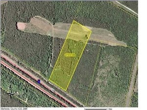
TRACT 251.490 AC, PARCEL 4 (03/2024)
Vacantlandnec
BERKELEY
BERKELEY C
South Carolina
B and X Area of moderate flood hazard, usually the area between the limits of the 100-year and 500-year floods.
51.49 AC
2025
Outlying Berkeley County
2025
Charleston/N Charleston
020710
Charleston-North Charleston, SC
NEARBY LISTINGS FOR SALE OR LEASE
DEMOGRAPHICS near 400 Strathmore Rd
1 mile
3 mile
5 mile
2025 Total Population
60
6,167
35,519
2030 Population
65
6,812
39,423
Pop Growth 2025-2030
+ 8.33%
+ 10.46%
+ 10.99%
Average Age
38
37
39
2025 Total Households
23
2,033
12,652
HH Growth 2025-2030
+ 8.70%
+ 11.02%
+ 11.63%
Median Household Inc
$84,375
$90,427
$87,937
Avg Household Size
2.70
2.90
2.70
2025 Avg HH Vehicles
2.00
2.00
2.00
Median Home Value
$350,000
$331,766
$361,720
Median Year Built
2005
2007
2006
Nearby Places
Map Layers
Map Styles
 Street
 Aerial
Layers
 Traffic
 Biking
Places
Listings with unknown addresses are not visible on the map
- Restaurants
- Banks
- Shops
- Fitness
- Groceries
PUBLIC TRANSPORTATION
AIRPORT
Charleston AFB/International
Drive
Walk
Distance
Charleston AFB/International
35 min
21.9 mi
Freight Ports
North Charleston Terminal
Drive
Walk
Distance
North Charleston Terminal
30 min
20.9 mi
SALE & LEASE HISTORY
LISTING DATE
SALE/LEASE

Sep 24, 2016
For Sale
Aug 29, 2019
For Sale
Nearby Properties
Address
Land Use
TOTAL SIZE
Lot Size
Zoning
Address
Land Use
TOTAL SIZE
Lot Size
Zoning
621,920 SF
87.29 AC
I_DC
Address
Land Use
TOTAL SIZE
Lot Size
Zoning
315,270 SF
25.81 AC
Address
Land Use
TOTAL SIZE
Lot Size
Zoning
849,992 SF
49.12 AC
BERKELEY C
Address
Land Use
TOTAL SIZE
Lot Size
Zoning
528,320 SF
38.11 AC
I_DC
Address
Land Use
TOTAL SIZE
Lot Size
Zoning
758,160 SF
50.45 AC
BERKELEY C
Address
Land Use
TOTAL SIZE
Lot Size
Zoning
611,520 SF
54.75 AC
Address
Land Use
TOTAL SIZE
Lot Size
Zoning
430,920 SF
35.26 AC
Address
Land Use
TOTAL SIZE
Lot Size
Zoning
586,560 SF
51.52 AC
BERKELEY C
Address
Land Use
TOTAL SIZE
Lot Size
Zoning
579,120 SF
42.86 AC
Address
Land Use
TOTAL SIZE
Lot Size
Zoning
615,426 SF
109.26 AC
BERKELEY C
Address
Land Use
TOTAL SIZE
Lot Size
Zoning
746,000 SF
49.64 AC
BERKELEY C
Address
Land Use
TOTAL SIZE
Lot Size
Zoning
575,260 SF
49.15 AC
BERKELEY C
Address
Land Use
TOTAL SIZE
Lot Size
Zoning
324,880 SF
50.65 AC
I_DC
Address
Land Use
TOTAL SIZE
Lot Size
Zoning
367,040 SF
22.09 AC
Address
Land Use
TOTAL SIZE
Lot Size
Zoning
362,880 SF
23.56 AC
Address
Land Use
TOTAL SIZE
Lot Size
Zoning
364,416 SF
56.32 AC
BERKELEY C
Address
Land Use
TOTAL SIZE
Lot Size
Zoning
451,170 SF
42.96 AC
BERKELEY C
Address
Land Use
TOTAL SIZE
Lot Size
Zoning
307,392 SF
45.21 AC
Address
Land Use
TOTAL SIZE
Lot Size
Zoning
351,520 SF
54.09 AC
BERKELEY C
Address
Land Use
TOTAL SIZE
Lot Size
Zoning
351,520 SF
37.61 AC
BERKELEY C
Address
Land Use
TOTAL SIZE
Lot Size
Zoning
231,400 SF
24.14 AC
I_DC
Address
Land Use
TOTAL SIZE
Lot Size
Zoning
343,200 SF
18.12 AC
HI
Address
Land Use
TOTAL SIZE
Lot Size
Zoning
200,880 SF
35.19 AC
Address
Land Use
TOTAL SIZE
Lot Size
Zoning
263,500 SF
34.30 AC
BERKELEY C
Address
Land Use
TOTAL SIZE
Lot Size
Zoning
340,200 SF
18.88 AC
Address
Land Use
TOTAL SIZE
Lot Size
Zoning
158,340 SF
28.93 AC
I_DC
Address
Land Use
TOTAL SIZE
Lot Size
Zoning
80,465 SF
19.07 AC
I_DC
Address
Land Use
TOTAL SIZE
Lot Size
Zoning
395,074 SF
21.33 AC
I_DC
Address
Land Use
TOTAL SIZE
Lot Size
Zoning
161,548 SF
16.56 AC
I_DC
Address
Land Use
TOTAL SIZE
Lot Size
Zoning
121,500 SF
40.85 AC
I_DC
The World's #1 Commercial Real Estate Marketplace
Connect with us
© 2026 CoStar Group
The information above has been obtained from sources believed reliable. While we do not doubt its accuracy we have not verified it and make no guarantee, warranty or representation about it. It is your responsibility to independently confirm its accuracy and completeness. Any projections, opinions, assumptions, or estimates used are for example only and do not represent the current or future performance of the property. The value of this transaction to you depends on tax and other factors which should be evaluated by your tax, financial, and legal advisors. You and your advisors should conduct a careful, independent investigation of the property to determine to your satisfaction the suitability of the property for your needs.