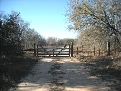
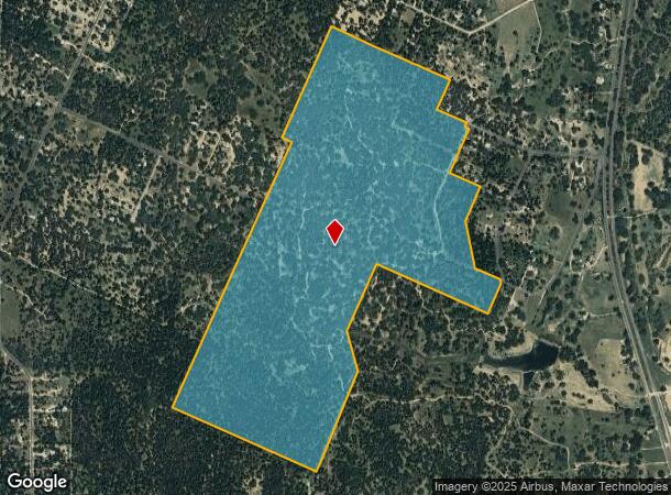
Property Record
400 Vine St, San Antonio, TX 78210

NEARBY LISTINGS FOR SALE OR LEASE
Property Detail
400 Vine St
San Antonio-New Braunfels, TX
Conv A/S Code
04173-000-0043
CB 4173 P-4B (5.916 AC), P-9 (0.221 AC), P-9 (4.48 AC) & P-17 (172.276); CB 4174 P-6A (62.973 AC), P-27 (3.986 AC), P-33 (0.553 AC), P-33A (0.825 AC) 2019-RESURVEYED FROM 245.015 TO 246.25 ACRES TO MATCH DEED 20180093438. JF/GIS/6-21-18.
Privatepreserveopenspacevacantlandforestlandconservation
Bexar
A
Texas
48013C0100C
1
2024
246.25 AC
2025
South
140400
San Antonio
DEMOGRAPHICS near 400 Vine St
1 Mile
3 Mile
5 Mile
2024 Total Population
580
8,451
19,052
2029 Population
614
9,061
20,465
Pop Growth 2024-2029
+ 5.86%
+ 7.22%
+ 7.42%
Average Age
37
37
37
2024 Total Households
174
2,566
5,747
HH Growth 2024-2029
+ 6.32%
+ 7.29%
+ 7.48%
Median Household Inc
$78,261
$44,765
$47,142
Avg Household Size
3.20
3.20
3.20
2024 Avg HH Vehicles
3.00
2.00
2.00
Median Home Value
$136,428
$141,289
$144,135
Median Year Built
1993
1994
1994
Nearby Places
Map Layers
Map Styles
 Street
 Aerial
- Restaurants
- Banks
- Shops
- Fitness
- Groceries
PUBLIC TRANSPORTATION
AIRPORT
San Antonio International
DRIVE
WALK
Distance
San Antonio International
49 min
28.4 mi
Freight Ports
Port of Corpus Christi
DRIVE
WALK
Distance
Port of Corpus Christi
148 min
129.1 mi
Nearby Properties
Address
Land Use
TOTAL SIZE
Lot Size
Zoning
Address
Land Use
TOTAL SIZE
Lot Size
Zoning
678.76 AC
Address
Land Use
TOTAL SIZE
Lot Size
Zoning
486.11 AC
Address
Land Use
TOTAL SIZE
Lot Size
Zoning
500.22 AC
Address
Land Use
TOTAL SIZE
Lot Size
Zoning
363.64 AC
Address
Land Use
TOTAL SIZE
Lot Size
Zoning
271.41 AC
Address
Land Use
TOTAL SIZE
Lot Size
Zoning
99.64 AC
Address
Land Use
TOTAL SIZE
Lot Size
Zoning
179.87 AC
Address
Land Use
TOTAL SIZE
Lot Size
Zoning
224.15 AC
Address
Land Use
TOTAL SIZE
Lot Size
Zoning
143.57 AC
Address
Land Use
TOTAL SIZE
Lot Size
Zoning
680 SF
10.78 AC
Address
Land Use
TOTAL SIZE
Lot Size
Zoning
720 SF
48.47 AC
Address
Land Use
TOTAL SIZE
Lot Size
Zoning
Address
Land Use
TOTAL SIZE
Lot Size
Zoning
9,034 SF
1.23 AC
Address
Land Use
TOTAL SIZE
Lot Size
Zoning
151.60 AC
Address
Land Use
TOTAL SIZE
Lot Size
Zoning
3,280 SF
186.35 AC
Address
Land Use
TOTAL SIZE
Lot Size
Zoning
Address
Land Use
TOTAL SIZE
Lot Size
Zoning
1,696 SF
149.02 AC
Address
Land Use
TOTAL SIZE
Lot Size
Zoning
93.70 AC
Address
Land Use
TOTAL SIZE
Lot Size
Zoning
95.13 AC
Address
Land Use
TOTAL SIZE
Lot Size
Zoning
34,626 SF
0.60 AC
Address
Land Use
TOTAL SIZE
Lot Size
Zoning
90.94 AC
Address
Land Use
TOTAL SIZE
Lot Size
Zoning
27.93 AC
Address
Land Use
TOTAL SIZE
Lot Size
Zoning
6,350 SF
5.05 AC
Address
Land Use
TOTAL SIZE
Lot Size
Zoning
46.06 AC
Address
Land Use
TOTAL SIZE
Lot Size
Zoning
1,238 SF
3.29 AC
Address
Land Use
TOTAL SIZE
Lot Size
Zoning
Address
Land Use
TOTAL SIZE
Lot Size
Zoning
19 SF
6.92 AC
Address
Land Use
TOTAL SIZE
Lot Size
Zoning
11.20 AC
The World's #1 Commercial Real Estate Marketplace
Connect with us
© 2026 CoStar Group
The information above has been obtained from sources believed reliable. While we do not doubt its accuracy we have not verified it and make no guarantee, warranty or representation about it. It is your responsibility to independently confirm its accuracy and completeness. Any projections, opinions, assumptions, or estimates used are for example only and do not represent the current or future performance of the property. The value of this transaction to you depends on tax and other factors which should be evaluated by your tax, financial, and legal advisors. You and your advisors should conduct a careful, independent investigation of the property to determine to your satisfaction the suitability of the property for your needs.