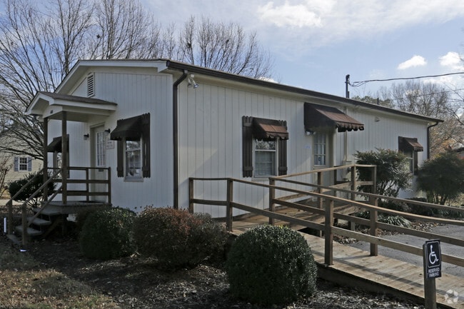
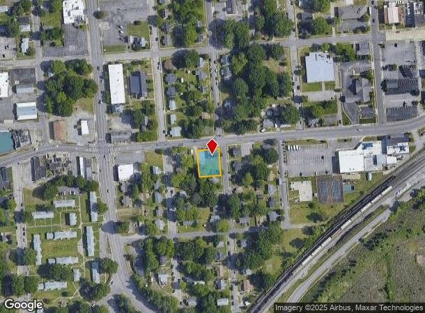
Property Record
400 W City Point Rd, Hopewell, VA 23860

NEARBY LISTINGS FOR SALE OR LEASE
Property Detail
400 W City Point Rd
Richmond, VA
B Village
011-1680
LOTS 5 & 6 BLK 43
Officebuilding
Hopewell City
X
Virginia
51041C0366E
5-6
2025
0.14 AC
2025
TriCities
820300
Richmond VA
1,064 SF
DEMOGRAPHICS near 400 W City Point Rd
1 Mile
3 Mile
5 Mile
2024 Total Population
6,921
26,739
53,929
2029 Population
6,906
26,831
55,100
Pop Growth 2024-2029
(0.22%)
+ 0.34%
+ 2.17%
Average Age
38
40
38
2024 Total Households
2,880
10,875
18,117
HH Growth 2024-2029
(0.17%)
+ 0.34%
+ 2.21%
Median Household Inc
$37,015
$49,391
$63,771
Avg Household Size
2.40
2.40
2.50
2024 Avg HH Vehicles
2.00
2.00
2.00
Median Home Value
$109,906
$148,204
$207,055
Median Year Built
1959
1971
1980
Nearby Places
Map Layers
Map Styles
 Street
 Aerial
- Restaurants
- Banks
- Shops
- Fitness
- Groceries
PUBLIC TRANSPORTATION
AIRPORT
Richmond International
DRIVE
WALK
Distance
Richmond International
30 min
20.5 mi
Freight Ports
Virginia Port Authority - Richmond
DRIVE
WALK
Distance
Virginia Port Authority - Richmond
27 min
17.6 mi
SALE & LEASE HISTORY
LISTING DATE
SALE/LEASE

Oct 20, 2021
For Sale
Oct 04, 2016
For Sale
Nov 09, 2017
For Sale
May 12, 2023
For Lease
May 03, 2019
For Sale
Mar 16, 2018
For Lease
Feb 22, 2021
For Sale
Nearby Properties
Address
Land Use
TOTAL SIZE
Lot Size
Zoning
Address
Land Use
TOTAL SIZE
Lot Size
Zoning
107.29 AC
Address
Land Use
TOTAL SIZE
Lot Size
Zoning
252,000 SF
118.66 AC
I3 - HVY I
Address
Land Use
TOTAL SIZE
Lot Size
Zoning
164.03 AC
M2
Address
Land Use
TOTAL SIZE
Lot Size
Zoning
137.06 AC
M2
Address
Land Use
TOTAL SIZE
Lot Size
Zoning
12,840 SF
389 AC
M2
Address
Land Use
TOTAL SIZE
Lot Size
Zoning
459.55 AC
I3 - HVY I
Address
Land Use
TOTAL SIZE
Lot Size
Zoning
177,075 SF
110.41 AC
R2
Address
Land Use
TOTAL SIZE
Lot Size
Zoning
1,512 SF
141.06 AC
TH
Address
Land Use
TOTAL SIZE
Lot Size
Zoning
91,105 SF
10.90 AC
C3 - COMMU
Address
Land Use
TOTAL SIZE
Lot Size
Zoning
13.70 AC
B2
Address
Land Use
TOTAL SIZE
Lot Size
Zoning
702 SF
34.72 AC
M2
Address
Land Use
TOTAL SIZE
Lot Size
Zoning
16 AC
R3
Address
Land Use
TOTAL SIZE
Lot Size
Zoning
356.70 AC
I3 - HVY I
Address
Land Use
TOTAL SIZE
Lot Size
Zoning
35,173 SF
19.30 AC
C3 - COMMU
Address
Land Use
TOTAL SIZE
Lot Size
Zoning
10.09 AC
R4
Address
Land Use
TOTAL SIZE
Lot Size
Zoning
29,585 SF
5.67 AC
R4
Address
Land Use
TOTAL SIZE
Lot Size
Zoning
95,603 SF
1.99 AC
B4
Address
Land Use
TOTAL SIZE
Lot Size
Zoning
10.78 AC
R4
Address
Land Use
TOTAL SIZE
Lot Size
Zoning
8,000 SF
52.80 AC
M2
Address
Land Use
TOTAL SIZE
Lot Size
Zoning
35,224 SF
3.87 AC
B1
Address
Land Use
TOTAL SIZE
Lot Size
Zoning
11,250 SF
7.36 AC
M2
Address
Land Use
TOTAL SIZE
Lot Size
Zoning
46,788 SF
1.95 AC
B3
Address
Land Use
TOTAL SIZE
Lot Size
Zoning
73,071 SF
1.42 AC
B4
Address
Land Use
TOTAL SIZE
Lot Size
Zoning
196.75 AC
A - AGRICU
Address
Land Use
TOTAL SIZE
Lot Size
Zoning
45,515 SF
4.28 AC
B2
Address
Land Use
TOTAL SIZE
Lot Size
Zoning
79,889 SF
16.67 AC
R3
Address
Land Use
TOTAL SIZE
Lot Size
Zoning
107.38 AC
M2
Address
Land Use
TOTAL SIZE
Lot Size
Zoning
0.25 AC
B1
Address
Land Use
TOTAL SIZE
Lot Size
Zoning
59,850 SF
3.33 AC
C5 - GEN B
Address
Land Use
TOTAL SIZE
Lot Size
Zoning
3.65 AC
R4
The World's #1 Commercial Real Estate Marketplace
Connect with us
© 2025 CoStar Group
The information above has been obtained from sources believed reliable. While we do not doubt its accuracy we have not verified it and make no guarantee, warranty or representation about it. It is your responsibility to independently confirm its accuracy and completeness. Any projections, opinions, assumptions, or estimates used are for example only and do not represent the current or future performance of the property. The value of this transaction to you depends on tax and other factors which should be evaluated by your tax, financial, and legal advisors. You and your advisors should conduct a careful, independent investigation of the property to determine to your satisfaction the suitability of the property for your needs.