Property Record
400 W Depot St, Angier, NC 27501


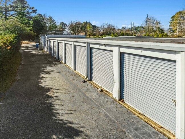
This Property Is For Sale
NEARBY LISTINGS FOR SALE OR LEASE
-
-
View all Angier listings for sale on LoopNet.com
Property Detail
400 W Depot St
04067419010008
Hockaday Stephenson & Gregory
Publicstorage
180X217 50X283 DEPOT ST
X
Harnett
3720066200J
North Carolina
2025
0.93 AC
2025
North Carolina Southeast Area
070904
Other Market Areas
2,500 SF
Anderson Creek, NC
DEMOGRAPHICS near 400 W Depot St
1 Mile
3 Mile
5 Mile
2024 Total Population
3,998
15,240
37,708
2029 Population
4,406
16,851
41,869
Pop Growth 2024-2029
+ 10.21%
+ 10.57%
+ 11.03%
Average Age
40
40
40
2024 Total Households
1,514
5,630
13,730
HH Growth 2024-2029
+ 10.04%
+ 10.48%
+ 11.10%
Median Household Inc
$61,364
$69,017
$82,258
Avg Household Size
2.60
2.70
2.70
2024 Avg HH Vehicles
2.00
2.00
2.00
Median Home Value
$321,299
$333,286
$371,736
Median Year Built
1997
2000
2004
Nearby Places
Map Layers
Map Styles
 Street
 Aerial
- Restaurants
- Banks
- Shops
- Fitness
- Groceries
PUBLIC TRANSPORTATION
AIRPORT
Raleigh-Durham International
DRIVE
WALK
Distance
Raleigh-Durham International
51 min
33.0 mi
Freight Ports
Port of Wilmington
DRIVE
WALK
Distance
Port of Wilmington
143 min
120.7 mi
Nearby Properties
Address
Land Use
TOTAL SIZE
Lot Size
Zoning
Address
Land Use
TOTAL SIZE
Lot Size
Zoning
38,728 SF
9.99 AC
RA-30
Address
Land Use
TOTAL SIZE
Lot Size
Zoning
89,919 SF
15.77 AC
OI
Address
Land Use
TOTAL SIZE
Lot Size
Zoning
76.04 AC
R-6
Address
Land Use
TOTAL SIZE
Lot Size
Zoning
47,048 SF
12.46 AC
Address
Land Use
TOTAL SIZE
Lot Size
Zoning
52.31 AC
R-6
Address
Land Use
TOTAL SIZE
Lot Size
Zoning
33.10 AC
R-6
Address
Land Use
TOTAL SIZE
Lot Size
Zoning
14,416 SF
1.61 AC
GC
Address
Land Use
TOTAL SIZE
Lot Size
Zoning
14,480 SF
5.10 AC
O&I
Address
Land Use
TOTAL SIZE
Lot Size
Zoning
96,923 SF
18.97 AC
Address
Land Use
TOTAL SIZE
Lot Size
Zoning
1,040 SF
2.24 AC
R10
Address
Land Use
TOTAL SIZE
Lot Size
Zoning
22,364 SF
2 AC
R10
Address
Land Use
TOTAL SIZE
Lot Size
Zoning
4,920 SF
5.97 AC
O&I
Address
Land Use
TOTAL SIZE
Lot Size
Zoning
39.06 AC
R-30
Address
Land Use
TOTAL SIZE
Lot Size
Zoning
9,935 SF
0.76 AC
GC
Address
Land Use
TOTAL SIZE
Lot Size
Zoning
640 SF
27.02 AC
AD-2
Address
Land Use
TOTAL SIZE
Lot Size
Zoning
4,410 SF
1.18 AC
GC
Address
Land Use
TOTAL SIZE
Lot Size
Zoning
25,156 SF
5.17 AC
RA30
Address
Land Use
TOTAL SIZE
Lot Size
Zoning
9,217 SF
1.44 AC
GC
Address
Land Use
TOTAL SIZE
Lot Size
Zoning
9,674 SF
7.65 AC
RA30
Address
Land Use
TOTAL SIZE
Lot Size
Zoning
1,125 SF
23.74 AC
RA30
Address
Land Use
TOTAL SIZE
Lot Size
Zoning
8,546 SF
1.43 AC
Address
Land Use
TOTAL SIZE
Lot Size
Zoning
19.63 AC
O&I
Address
Land Use
TOTAL SIZE
Lot Size
Zoning
8,400 SF
0.52 AC
GC
Address
Land Use
TOTAL SIZE
Lot Size
Zoning
9,336 SF
14.26 AC
R15
Address
Land Use
TOTAL SIZE
Lot Size
Zoning
960 SF
69.95 AC
R-30
Address
Land Use
TOTAL SIZE
Lot Size
Zoning
2,808 SF
0.70 AC
Address
Land Use
TOTAL SIZE
Lot Size
Zoning
35.73 AC
RA30
Address
Land Use
TOTAL SIZE
Lot Size
Zoning
67.23 AC
R-30
Address
Land Use
TOTAL SIZE
Lot Size
Zoning
4,056 SF
30.43 AC
R-30
Address
Land Use
TOTAL SIZE
Lot Size
Zoning
32.74 AC
RA30
The World's #1 Commercial Real Estate Marketplace
Connect with us
© 2026 CoStar Group
The information above has been obtained from sources believed reliable. While we do not doubt its accuracy we have not verified it and make no guarantee, warranty or representation about it. It is your responsibility to independently confirm its accuracy and completeness. Any projections, opinions, assumptions, or estimates used are for example only and do not represent the current or future performance of the property. The value of this transaction to you depends on tax and other factors which should be evaluated by your tax, financial, and legal advisors. You and your advisors should conduct a careful, independent investigation of the property to determine to your satisfaction the suitability of the property for your needs.