No Photo
Property Record
400 W Main St, Mount Summit, IN 47361

Save to a Folder
{{folder.Name}}
{{folder.ListingIds.length}} Properties
{{folder.ListingIds.length}} Property
Create a New Folder
Property Detail
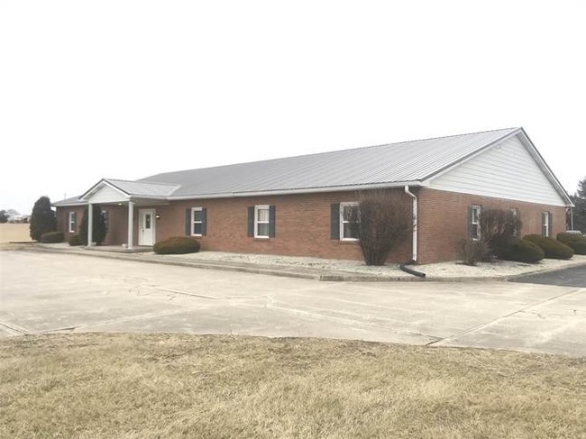
400 W Main St
33-07-16-000-404.000-021
PT SE1/4 16-18-10 37.295A
Storageyardopenstoragelightequipmentmaterial
HENRY
B and X Area of moderate flood hazard, usually the area between the limits of the 100-year and 500-year floods.
Indiana
2025
37.30 AC
2025
Henry County
975600
Indianapolis
180,061 SF
New Castle, IN
NEARBY LISTINGS FOR SALE OR LEASE
-
-
View all Mount Summit listings for lease on LoopNet.com
DEMOGRAPHICS near 400 W Main St
1 mile
3 mile
5 mile
2025 Total Population
320
5,228
9,340
2030 Population
303
5,176
9,287
Pop Growth 2025-2030
(5.31%)
(0.99%)
(0.57%)
Average Age
46
46
45
2025 Total Households
133
920
2,551
HH Growth 2025-2030
(5.26%)
(2.17%)
(0.78%)
Median Household Inc
$71,249
$68,546
$59,902
Avg Household Size
2.40
2.40
2.40
2025 Avg HH Vehicles
2.00
2.00
2.00
Median Home Value
$241,964
$196,511
$175,293
Median Year Built
1975
1974
1968
Nearby Places
Map Layers
Map Styles
 Street
 Aerial
Layers
 Traffic
 Biking
Places
Listings with unknown addresses are not visible on the map
- Restaurants
- Banks
- Shops
- Fitness
- Groceries
SALE & LEASE HISTORY
LISTING DATE
SALE/LEASE

May 15, 2019
For Lease
Jan 28, 2019
For Lease
Nearby Properties
Address
Land Use
TOTAL SIZE
Lot Size
Zoning
Address
Land Use
TOTAL SIZE
Lot Size
Zoning
45,468 SF
35.65 AC
Address
Land Use
TOTAL SIZE
Lot Size
Zoning
21,600 SF
6 AC
Address
Land Use
TOTAL SIZE
Lot Size
Zoning
13,499 SF
18.96 AC
Address
Land Use
TOTAL SIZE
Lot Size
Zoning
9,100 SF
1.51 AC
Address
Land Use
TOTAL SIZE
Lot Size
Zoning
2,720 SF
17.93 AC
Address
Land Use
TOTAL SIZE
Lot Size
Zoning
19,000 SF
10.64 AC
Address
Land Use
TOTAL SIZE
Lot Size
Zoning
16,152 SF
6.21 AC
Address
Land Use
TOTAL SIZE
Lot Size
Zoning
1,804 SF
133.64 AC
Address
Land Use
TOTAL SIZE
Lot Size
Zoning
3,846 SF
0.40 AC
Address
Land Use
TOTAL SIZE
Lot Size
Zoning
19,760 SF
2.12 AC
Address
Land Use
TOTAL SIZE
Lot Size
Zoning
170.02 AC
Address
Land Use
TOTAL SIZE
Lot Size
Zoning
158.03 AC
Address
Land Use
TOTAL SIZE
Lot Size
Zoning
1,656 SF
157.60 AC
Address
Land Use
TOTAL SIZE
Lot Size
Zoning
Address
Land Use
TOTAL SIZE
Lot Size
Zoning
120.07 AC
Address
Land Use
TOTAL SIZE
Lot Size
Zoning
8,650 SF
0.45 AC
Address
Land Use
TOTAL SIZE
Lot Size
Zoning
Address
Land Use
TOTAL SIZE
Lot Size
Zoning
Address
Land Use
TOTAL SIZE
Lot Size
Zoning
7,024 SF
9.12 AC
Address
Land Use
TOTAL SIZE
Lot Size
Zoning
158.88 AC
Address
Land Use
TOTAL SIZE
Lot Size
Zoning
115.99 AC
Address
Land Use
TOTAL SIZE
Lot Size
Zoning
125.28 AC
Address
Land Use
TOTAL SIZE
Lot Size
Zoning
3,348 SF
0.54 AC
Address
Land Use
TOTAL SIZE
Lot Size
Zoning
3,760 SF
3.44 AC
Address
Land Use
TOTAL SIZE
Lot Size
Zoning
Address
Land Use
TOTAL SIZE
Lot Size
Zoning
103.47 AC
Address
Land Use
TOTAL SIZE
Lot Size
Zoning
150.17 AC
Address
Land Use
TOTAL SIZE
Lot Size
Zoning
Address
Land Use
TOTAL SIZE
Lot Size
Zoning
149.51 AC
The World's #1 Commercial Real Estate Marketplace
Connect with us
© 2026 CoStar Group
The information above has been obtained from sources believed reliable. While we do not doubt its accuracy we have not verified it and make no guarantee, warranty or representation about it. It is your responsibility to independently confirm its accuracy and completeness. Any projections, opinions, assumptions, or estimates used are for example only and do not represent the current or future performance of the property. The value of this transaction to you depends on tax and other factors which should be evaluated by your tax, financial, and legal advisors. You and your advisors should conduct a careful, independent investigation of the property to determine to your satisfaction the suitability of the property for your needs.