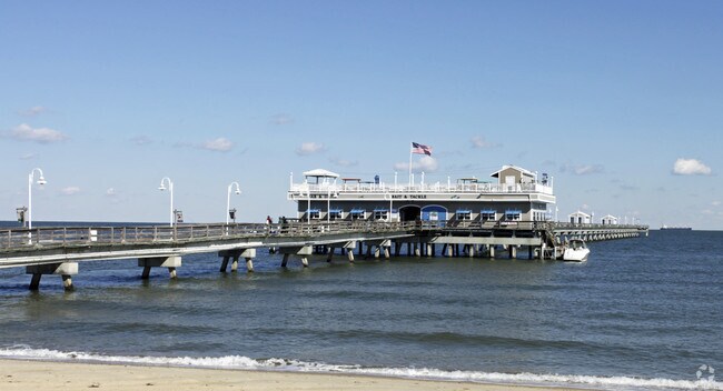
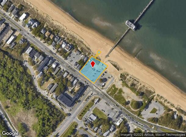
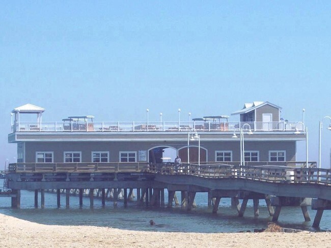
Property Record
400-444 W Ocean View Ave, Norfolk, VA 23503
NEARBY LISTINGS FOR SALE OR LEASE
Property Detail
400-444 W Ocean View Ave
Virginia Beach-Norfolk-Newport News, VA-NC
Willoughby Beach
19159675
LOTS 13, 14, 15 & PT 12, BLK 9
Restaurantbuilding
Norfolk City
VE
Virginia
5101040009H
12-14
2025
0.99 AC
2025
Little Creek
000400
Hampton Roads
3,496 SF
DEMOGRAPHICS near 400-444 W Ocean View Ave
1 Mile
3 Mile
5 Mile
2024 Total Population
16,587
50,492
119,018
2029 Population
16,219
49,305
116,045
Pop Growth 2024-2029
(2.22%)
(2.35%)
(2.50%)
Average Age
31
35
37
2024 Total Households
3,370
17,484
45,557
HH Growth 2024-2029
(2.67%)
(2.68%)
(2.84%)
Median Household Inc
$54,596
$60,310
$61,574
Avg Household Size
2.10
2.30
2.30
2024 Avg HH Vehicles
2.00
2.00
2.00
Median Home Value
$291,033
$243,814
$259,966
Median Year Built
1967
1960
1964
Nearby Places
Map Layers
Map Styles
 Street
 Aerial
- Restaurants
- Banks
- Shops
- Fitness
- Groceries
PUBLIC TRANSPORTATION
COMMUTER RAIL
Norfolk (Northeast Regional - Amtrak)
DRIVE
WALK
Distance
Norfolk (Northeast Regional - Amtrak)
16 min
9.3 mi
AIRPORT
Norfolk International
DRIVE
WALK
Distance
Norfolk International
14 min
7.3 mi
Newport News/Williamsburg International
DRIVE
WALK
Distance
Newport News/Williamsburg International
31 min
21.1 mi
Freight Ports
Virginia Port Authority - Norfolk
DRIVE
WALK
Distance
Virginia Port Authority - Norfolk
16 min
7.2 mi
Nearby Properties
Address
Land Use
TOTAL SIZE
Lot Size
Zoning
Address
Land Use
TOTAL SIZE
Lot Size
Zoning
777.89 AC
Address
Land Use
TOTAL SIZE
Lot Size
Zoning
8,423 SF
53.95 AC
Address
Land Use
TOTAL SIZE
Lot Size
Zoning
167,279 SF
9.97 AC
IN1
Address
Land Use
TOTAL SIZE
Lot Size
Zoning
103,496 SF
25.81 AC
IN1
Address
Land Use
TOTAL SIZE
Lot Size
Zoning
14.02 AC
Address
Land Use
TOTAL SIZE
Lot Size
Zoning
41,754 SF
6.01 AC
Address
Land Use
TOTAL SIZE
Lot Size
Zoning
68.02 AC
Address
Land Use
TOTAL SIZE
Lot Size
Zoning
25,880 SF
31.21 AC
91
Address
Land Use
TOTAL SIZE
Lot Size
Zoning
23.85 AC
IN1
Address
Land Use
TOTAL SIZE
Lot Size
Zoning
15,898 SF
9.91 AC
IN1
Address
Land Use
TOTAL SIZE
Lot Size
Zoning
28,064 SF
7.48 AC
C2
Address
Land Use
TOTAL SIZE
Lot Size
Zoning
63,459 SF
20.06 AC
IN1
Address
Land Use
TOTAL SIZE
Lot Size
Zoning
28,708 SF
3.16 AC
C2
Address
Land Use
TOTAL SIZE
Lot Size
Zoning
251.28 AC
OSP
Address
Land Use
TOTAL SIZE
Lot Size
Zoning
7,240 SF
2.80 AC
R12
Address
Land Use
TOTAL SIZE
Lot Size
Zoning
10,580 SF
5.63 AC
R12
Address
Land Use
TOTAL SIZE
Lot Size
Zoning
2,214 SF
7.78 AC
Address
Land Use
TOTAL SIZE
Lot Size
Zoning
85,600 SF
3.92 AC
Address
Land Use
TOTAL SIZE
Lot Size
Zoning
7.08 AC
Address
Land Use
TOTAL SIZE
Lot Size
Zoning
21,052 SF
4.45 AC
R12
Address
Land Use
TOTAL SIZE
Lot Size
Zoning
5.77 AC
Address
Land Use
TOTAL SIZE
Lot Size
Zoning
26,080 SF
6.93 AC
C2
Address
Land Use
TOTAL SIZE
Lot Size
Zoning
42,592 SF
3.06 AC
R13
Address
Land Use
TOTAL SIZE
Lot Size
Zoning
53,229 SF
6.81 AC
IN1
Address
Land Use
TOTAL SIZE
Lot Size
Zoning
41,316 SF
2.45 AC
R12
Address
Land Use
TOTAL SIZE
Lot Size
Zoning
6,150 SF
8.07 AC
PDRSPECTR
Address
Land Use
TOTAL SIZE
Lot Size
Zoning
8.36 AC
C2
Address
Land Use
TOTAL SIZE
Lot Size
Zoning
58,990 SF
3.60 AC
C2
Address
Land Use
TOTAL SIZE
Lot Size
Zoning
43,040 SF
2.02 AC
IN1
Address
Land Use
TOTAL SIZE
Lot Size
Zoning
21,264 SF
2.41 AC
The World's #1 Commercial Real Estate Marketplace
Connect with us
© 2025 CoStar Group
The information above has been obtained from sources believed reliable. While we do not doubt its accuracy we have not verified it and make no guarantee, warranty or representation about it. It is your responsibility to independently confirm its accuracy and completeness. Any projections, opinions, assumptions, or estimates used are for example only and do not represent the current or future performance of the property. The value of this transaction to you depends on tax and other factors which should be evaluated by your tax, financial, and legal advisors. You and your advisors should conduct a careful, independent investigation of the property to determine to your satisfaction the suitability of the property for your needs.