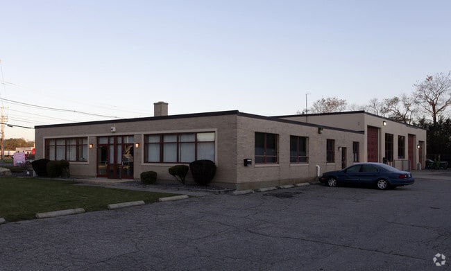
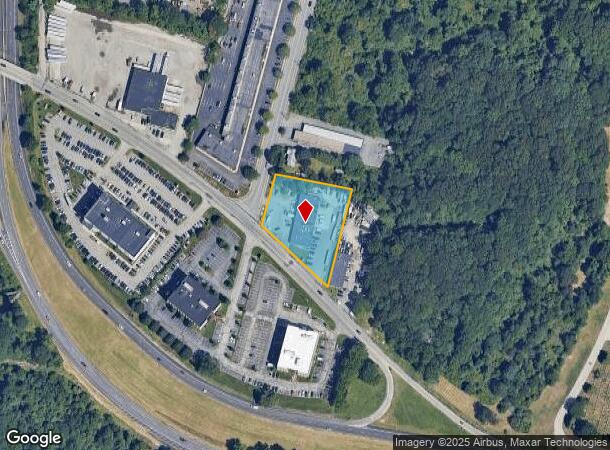
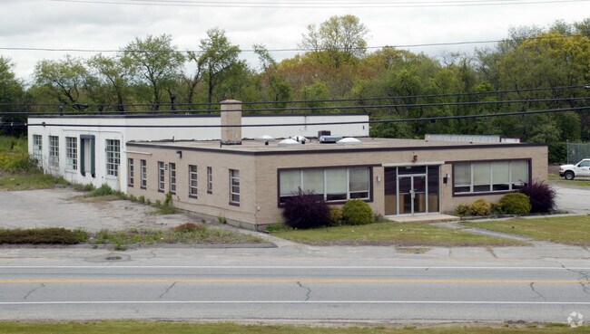
Property Record
400 Wampanoag Trl, Riverside, RI 02915
NEARBY LISTINGS FOR SALE OR LEASE
Property Detail
400 Wampanoag Trl
EPRO-000509-000005-000003
Providence
Commercialbuilding
Rhode Island
X
3
44007C0336H
1.17 AC
2025
East Providence
2025
Providence
010501
Providence-Warwick, RI-MA
8,640 SF
DEMOGRAPHICS near 400 Wampanoag Trl
1 Mile
3 Mile
5 Mile
2024 Total Population
6,192
64,942
228,939
2029 Population
6,194
64,545
227,529
Pop Growth 2024-2029
+ 0.03%
(0.61%)
(0.62%)
Average Age
43
42
40
2024 Total Households
2,702
27,057
92,310
HH Growth 2024-2029
+ 0.04%
(0.65%)
(0.50%)
Median Household Inc
$64,962
$69,883
$69,119
Avg Household Size
2.20
2.30
2.30
2024 Avg HH Vehicles
2.00
2.00
2.00
Median Home Value
$283,584
$307,858
$336,307
Median Year Built
1966
1954
1949
Nearby Places
Map Layers
Map Styles
 Street
 Aerial
- Restaurants
- Banks
- Shops
- Fitness
- Groceries
PUBLIC TRANSPORTATION
COMMUTER RAIL
Providence (Providence/Stoughton Line - Massachusetts Bay Transportation Authority Commuter Rail (Purple Line))
DRIVE
WALK
Distance
Providence (Providence/Stoughton Line - Massachusetts Bay Transportation Authority Commuter Rail (Purple Line))
10 min
6.4 mi
AIRPORT
Rhode Island Tf Green International
DRIVE
WALK
Distance
Rhode Island Tf Green International
22 min
13.7 mi
Freight Ports
Port of Davisville, RI
DRIVE
WALK
Distance
Port of Davisville, RI
1 min
12.8 mi
Nearby Properties
Address
Land Use
TOTAL SIZE
Lot Size
Zoning
Address
Land Use
TOTAL SIZE
Lot Size
Zoning
317,728 SF
28.20 AC
O1
Address
Land Use
TOTAL SIZE
Lot Size
Zoning
Address
Land Use
TOTAL SIZE
Lot Size
Zoning
7.53 AC
I-2
Address
Land Use
TOTAL SIZE
Lot Size
Zoning
15.20 AC
R5
Address
Land Use
TOTAL SIZE
Lot Size
Zoning
104,999 SF
8.86 AC
C-3
Address
Land Use
TOTAL SIZE
Lot Size
Zoning
455.47 AC
I3
Address
Land Use
TOTAL SIZE
Lot Size
Zoning
139.58 AC
O1
Address
Land Use
TOTAL SIZE
Lot Size
Zoning
16.48 AC
W-3
Address
Land Use
TOTAL SIZE
Lot Size
Zoning
10.90 AC
EI
Address
Land Use
TOTAL SIZE
Lot Size
Zoning
225,067 SF
40.70 AC
HB
Address
Land Use
TOTAL SIZE
Lot Size
Zoning
4.91 AC
I-2
Address
Land Use
TOTAL SIZE
Lot Size
Zoning
Address
Land Use
TOTAL SIZE
Lot Size
Zoning
18.01 AC
C3
Address
Land Use
TOTAL SIZE
Lot Size
Zoning
248,000 SF
75.88 AC
I
Address
Land Use
TOTAL SIZE
Lot Size
Zoning
4.62 AC
R5
Address
Land Use
TOTAL SIZE
Lot Size
Zoning
77,631 SF
2.97 AC
I-2
Address
Land Use
TOTAL SIZE
Lot Size
Zoning
12.67 AC
R5
Address
Land Use
TOTAL SIZE
Lot Size
Zoning
9.35 AC
C1
Address
Land Use
TOTAL SIZE
Lot Size
Zoning
170,345 SF
3.76 AC
R6
Address
Land Use
TOTAL SIZE
Lot Size
Zoning
171,290 SF
27.80 AC
R2
Address
Land Use
TOTAL SIZE
Lot Size
Zoning
53.20 AC
C1
Address
Land Use
TOTAL SIZE
Lot Size
Zoning
225,458 SF
24.95 AC
I1
Address
Land Use
TOTAL SIZE
Lot Size
Zoning
155,770 SF
1.37 AC
M-1
Address
Land Use
TOTAL SIZE
Lot Size
Zoning
201,941 SF
5.30 AC
I-2
Address
Land Use
TOTAL SIZE
Lot Size
Zoning
223,374 SF
14 AC
O1
Address
Land Use
TOTAL SIZE
Lot Size
Zoning
4.82 AC
I-2
Address
Land Use
TOTAL SIZE
Lot Size
Zoning
87,544 SF
5.05 AC
KP
Address
Land Use
TOTAL SIZE
Lot Size
Zoning
7.44 AC
R5
Address
Land Use
TOTAL SIZE
Lot Size
Zoning
6.58 AC
R5
Address
Land Use
TOTAL SIZE
Lot Size
Zoning
17.24 AC
W-3
The World's #1 Commercial Real Estate Marketplace
Connect with us
© 2025 CoStar Group
The information above has been obtained from sources believed reliable. While we do not doubt its accuracy we have not verified it and make no guarantee, warranty or representation about it. It is your responsibility to independently confirm its accuracy and completeness. Any projections, opinions, assumptions, or estimates used are for example only and do not represent the current or future performance of the property. The value of this transaction to you depends on tax and other factors which should be evaluated by your tax, financial, and legal advisors. You and your advisors should conduct a careful, independent investigation of the property to determine to your satisfaction the suitability of the property for your needs.