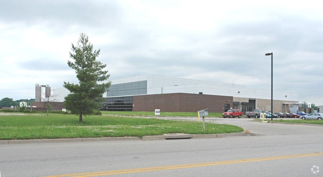
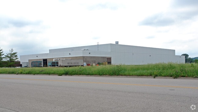
Property Record
4000 N Kimball Dr, Kansas City, MO 64161

NEARBY LISTINGS FOR SALE OR LEASE
Property Detail
4000 N Kimball Dr
Kansas City, MO-KS
Northland Park
18-302-00-02-005.00
NORTHLAND PARK LT 8D (I-135.1) A/K/A LTS 8A & 8B (D-54) A/K/A PT LT 8 BEG SW COR LT 8, N884, E TO WL N KIMBALL DR, S TO NL NE 40TH ST, W ALNG ROW TO POB
Commercialnec
Clay
X
Missouri
29095C0162G
8
2024
9.84 AC
2025
Claycomo
022200
Kansas City
DEMOGRAPHICS near 4000 N Kimball Dr
1 Mile
3 Mile
5 Mile
2024 Total Population
242
3,872
70,447
2029 Population
255
4,023
72,506
Pop Growth 2024-2029
+ 5.37%
+ 3.90%
+ 2.92%
Average Age
40
37
39
2024 Total Households
89
1,425
27,713
HH Growth 2024-2029
+ 4.49%
+ 3.79%
+ 2.89%
Median Household Inc
$46,250
$72,223
$62,150
Avg Household Size
2.80
2.70
2.50
2024 Avg HH Vehicles
2.00
2.00
2.00
Median Home Value
$146,875
$145,967
$165,214
Median Year Built
1968
1963
1967
Nearby Places
Map Layers
Map Styles
 Street
 Aerial
- Restaurants
- Banks
- Shops
- Fitness
- Groceries
PUBLIC TRANSPORTATION
AIRPORT
Kansas City International
DRIVE
WALK
Distance
Kansas City International
36 min
25.6 mi
Nearby Properties
Address
Land Use
TOTAL SIZE
Lot Size
Zoning
Address
Land Use
TOTAL SIZE
Lot Size
Zoning
Address
Land Use
TOTAL SIZE
Lot Size
Zoning
Address
Land Use
TOTAL SIZE
Lot Size
Zoning
96.58 AC
Address
Land Use
TOTAL SIZE
Lot Size
Zoning
84.66 AC
Address
Land Use
TOTAL SIZE
Lot Size
Zoning
23.13 AC
Address
Land Use
TOTAL SIZE
Lot Size
Zoning
20.82 AC
Address
Land Use
TOTAL SIZE
Lot Size
Zoning
68.64 AC
Address
Land Use
TOTAL SIZE
Lot Size
Zoning
22.99 AC
Address
Land Use
TOTAL SIZE
Lot Size
Zoning
84.31 AC
Address
Land Use
TOTAL SIZE
Lot Size
Zoning
21.38 AC
Address
Land Use
TOTAL SIZE
Lot Size
Zoning
108.96 AC
Address
Land Use
TOTAL SIZE
Lot Size
Zoning
255.96 AC
Address
Land Use
TOTAL SIZE
Lot Size
Zoning
Address
Land Use
TOTAL SIZE
Lot Size
Zoning
38.32 AC
Address
Land Use
TOTAL SIZE
Lot Size
Zoning
Address
Land Use
TOTAL SIZE
Lot Size
Zoning
18,407 SF
28.30 AC
Address
Land Use
TOTAL SIZE
Lot Size
Zoning
Address
Land Use
TOTAL SIZE
Lot Size
Zoning
19.03 AC
Address
Land Use
TOTAL SIZE
Lot Size
Zoning
Address
Land Use
TOTAL SIZE
Lot Size
Zoning
69.90 AC
Address
Land Use
TOTAL SIZE
Lot Size
Zoning
12.39 AC
Address
Land Use
TOTAL SIZE
Lot Size
Zoning
41.57 AC
Address
Land Use
TOTAL SIZE
Lot Size
Zoning
Address
Land Use
TOTAL SIZE
Lot Size
Zoning
155,098 SF
94.87 AC
Address
Land Use
TOTAL SIZE
Lot Size
Zoning
16.63 AC
Address
Land Use
TOTAL SIZE
Lot Size
Zoning
10.16 AC
Address
Land Use
TOTAL SIZE
Lot Size
Zoning
10.06 AC
Address
Land Use
TOTAL SIZE
Lot Size
Zoning
89.72 AC
Address
Land Use
TOTAL SIZE
Lot Size
Zoning
The World's #1 Commercial Real Estate Marketplace
Connect with us
© 2026 CoStar Group
The information above has been obtained from sources believed reliable. While we do not doubt its accuracy we have not verified it and make no guarantee, warranty or representation about it. It is your responsibility to independently confirm its accuracy and completeness. Any projections, opinions, assumptions, or estimates used are for example only and do not represent the current or future performance of the property. The value of this transaction to you depends on tax and other factors which should be evaluated by your tax, financial, and legal advisors. You and your advisors should conduct a careful, independent investigation of the property to determine to your satisfaction the suitability of the property for your needs.