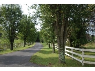
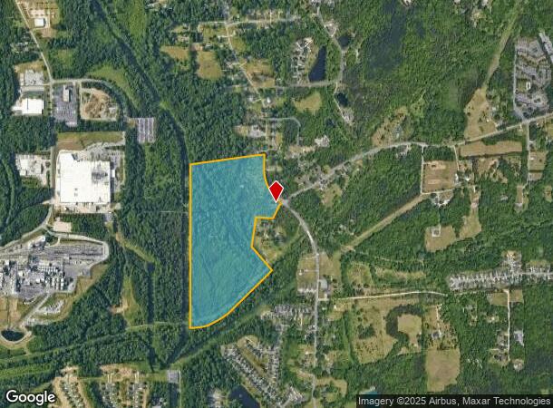
Property Record
4000 Old Lexington Rd, Winston Salem, NC 27107
NEARBY LISTINGS FOR SALE OR LEASE
Property Detail
4000 Old Lexington Rd
Winston-Salem, NC
Thomasville & Cole Rds
6833-93-5541
VACANT LO:001C BL:2720 BU:1
Commercialnec
Forsyth
AE
North Carolina
3710683300J
1c
2023
50.10 AC
2025
SE Forsyth County
003500
Greensboro/Winston-Salem
840 SF
DEMOGRAPHICS near 4000 Old Lexington Rd
1 Mile
3 Mile
5 Mile
2024 Total Population
3,521
38,742
110,506
2029 Population
3,674
40,353
115,408
Pop Growth 2024-2029
+ 4.35%
+ 4.16%
+ 4.44%
Average Age
37
36
38
2024 Total Households
1,385
14,587
44,639
HH Growth 2024-2029
+ 4.12%
+ 4.17%
+ 4.54%
Median Household Inc
$48,584
$45,785
$50,831
Avg Household Size
2.50
2.50
2.30
2024 Avg HH Vehicles
2.00
2.00
2.00
Median Home Value
$173,076
$143,659
$172,733
Median Year Built
1995
1980
1980
Nearby Places
Map Layers
Map Styles
 Street
 Aerial
- Restaurants
- Banks
- Shops
- Fitness
- Groceries
PUBLIC TRANSPORTATION
AIRPORT
Piedmont Triad International
DRIVE
WALK
Distance
Piedmont Triad International
36 min
21.3 mi
Freight Ports
Port of Wilmington
DRIVE
WALK
Distance
Port of Wilmington
273 min
228.2 mi
SALE & LEASE HISTORY
LISTING DATE
SALE/LEASE

Sep 24, 2016
For Sale
Mar 31, 2017
For Sale
Nearby Properties
Address
Land Use
TOTAL SIZE
Lot Size
Zoning
Address
Land Use
TOTAL SIZE
Lot Size
Zoning
160,152 SF
26 AC
RM12-S,RM1
Address
Land Use
TOTAL SIZE
Lot Size
Zoning
108,412 SF
15.15 AC
RM18-S
Address
Land Use
TOTAL SIZE
Lot Size
Zoning
162,844 SF
57.77 AC
IP
Address
Land Use
TOTAL SIZE
Lot Size
Zoning
211,658 SF
27.33 AC
MRB-S
Address
Land Use
TOTAL SIZE
Lot Size
Zoning
79,734 SF
22.54 AC
RM12-S
Address
Land Use
TOTAL SIZE
Lot Size
Zoning
59,612 SF
10.91 AC
MU-S
Address
Land Use
TOTAL SIZE
Lot Size
Zoning
186,776 SF
25.80 AC
IP
Address
Land Use
TOTAL SIZE
Lot Size
Zoning
176,680 SF
10.54 AC
MU-S
Address
Land Use
TOTAL SIZE
Lot Size
Zoning
57,837 SF
9.45 AC
RM18-S
Address
Land Use
TOTAL SIZE
Lot Size
Zoning
102,588 SF
13.98 AC
RM18
Address
Land Use
TOTAL SIZE
Lot Size
Zoning
167,500 SF
14.96 AC
GI
Address
Land Use
TOTAL SIZE
Lot Size
Zoning
48,620 SF
15.51 AC
RM12-S
Address
Land Use
TOTAL SIZE
Lot Size
Zoning
992,551 SF
72.46 AC
GI
Address
Land Use
TOTAL SIZE
Lot Size
Zoning
415,099 SF
104.61 AC
LI,RS9
Address
Land Use
TOTAL SIZE
Lot Size
Zoning
72,617 SF
13.85 AC
RM18
Address
Land Use
TOTAL SIZE
Lot Size
Zoning
139,248 SF
27.24 AC
MRB-S
Address
Land Use
TOTAL SIZE
Lot Size
Zoning
188,088 SF
26.83 AC
RM18
Address
Land Use
TOTAL SIZE
Lot Size
Zoning
707,739 SF
60.36 AC
GI
Address
Land Use
TOTAL SIZE
Lot Size
Zoning
469,797 SF
73.87 AC
GI
Address
Land Use
TOTAL SIZE
Lot Size
Zoning
68,010 SF
15.32 AC
IP,RS9
Address
Land Use
TOTAL SIZE
Lot Size
Zoning
96,089 SF
14.91 AC
HB-S
Address
Land Use
TOTAL SIZE
Lot Size
Zoning
21,489 SF
4.44 AC
RM18
Address
Land Use
TOTAL SIZE
Lot Size
Zoning
367,405 SF
21.46 AC
GI
Address
Land Use
TOTAL SIZE
Lot Size
Zoning
95,024 SF
4.54 AC
GB-L
Address
Land Use
TOTAL SIZE
Lot Size
Zoning
115,144 SF
10.31 AC
HB-S
Address
Land Use
TOTAL SIZE
Lot Size
Zoning
127,202 SF
10.47 AC
HB
Address
Land Use
TOTAL SIZE
Lot Size
Zoning
84,437 SF
9.28 AC
HB
Address
Land Use
TOTAL SIZE
Lot Size
Zoning
48,831 SF
2.83 AC
GB-S
Address
Land Use
TOTAL SIZE
Lot Size
Zoning
35,395 SF
3.72 AC
MRB-S
Address
Land Use
TOTAL SIZE
Lot Size
Zoning
98,428 SF
11.27 AC
IP
The World's #1 Commercial Real Estate Marketplace
Connect with us
© 2026 CoStar Group
The information above has been obtained from sources believed reliable. While we do not doubt its accuracy we have not verified it and make no guarantee, warranty or representation about it. It is your responsibility to independently confirm its accuracy and completeness. Any projections, opinions, assumptions, or estimates used are for example only and do not represent the current or future performance of the property. The value of this transaction to you depends on tax and other factors which should be evaluated by your tax, financial, and legal advisors. You and your advisors should conduct a careful, independent investigation of the property to determine to your satisfaction the suitability of the property for your needs.