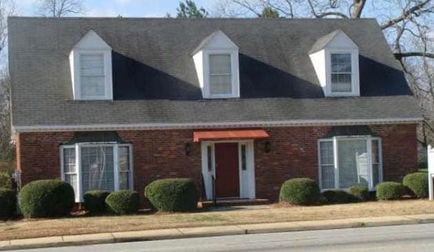
Property Record
4020 Vineville Ave, Macon, GA 31210
NEARBY LISTINGS FOR SALE OR LEASE
Property Detail
4020 Vineville Ave
Macon-Bibb County, GA
W C Hills Subdivision
N061-0168
W C HILL
Officebuilding
Bibb
X
Georgia
13021C0127G
338
2025
0.45 AC
2025
Suburban Macon
013408
Atlanta
2,352 SF
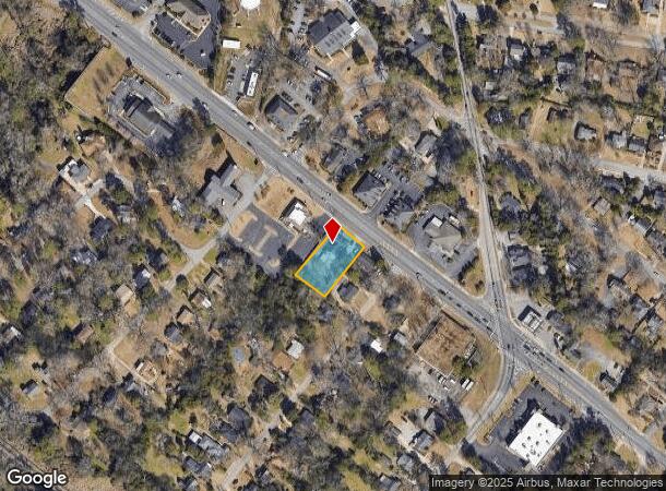
DEMOGRAPHICS near 4020 Vineville Ave
1 Mile
3 Mile
5 Mile
2024 Total Population
6,515
42,605
99,787
2029 Population
6,406
42,160
99,072
Pop Growth 2024-2029
(1.67%)
(1.04%)
(0.72%)
Average Age
38
39
38
2024 Total Households
2,823
18,114
41,472
HH Growth 2024-2029
(1.70%)
(1.09%)
(0.67%)
Median Household Inc
$65,374
$49,281
$46,471
Avg Household Size
2.30
2.30
2.30
2024 Avg HH Vehicles
2.00
2.00
2.00
Median Home Value
$194,434
$154,420
$152,552
Median Year Built
1972
1969
1973
Nearby Places
Map Layers
Map Styles
 Street
 Aerial
- Restaurants
- Banks
- Shops
- Fitness
- Groceries
SALE & LEASE HISTORY
LISTING DATE
SALE/LEASE

Sep 25, 2016
For Lease
Sep 23, 2016
For Sale
Mar 27, 2018
For Lease
Jan 08, 2018
For Sale
Nearby Properties
Address
Land Use
TOTAL SIZE
Lot Size
Zoning
Address
Land Use
TOTAL SIZE
Lot Size
Zoning
Address
Land Use
TOTAL SIZE
Lot Size
Zoning
196,702 SF
37.72 AC
PDE
Address
Land Use
TOTAL SIZE
Lot Size
Zoning
71,021 SF
8.94 AC
PDC
Address
Land Use
TOTAL SIZE
Lot Size
Zoning
231,774 SF
21.27 AC
R-1AAA
Address
Land Use
TOTAL SIZE
Lot Size
Zoning
199,096 SF
22.03 AC
R-2
Address
Land Use
TOTAL SIZE
Lot Size
Zoning
51,786 SF
21.05 AC
PDR
Address
Land Use
TOTAL SIZE
Lot Size
Zoning
1,039 SF
14.79 AC
PDR
Address
Land Use
TOTAL SIZE
Lot Size
Zoning
1,452 SF
12.16 AC
R-3
Address
Land Use
TOTAL SIZE
Lot Size
Zoning
6,720 SF
16.69 AC
PDR
Address
Land Use
TOTAL SIZE
Lot Size
Zoning
85,556 SF
10.50 AC
R-1A
Address
Land Use
TOTAL SIZE
Lot Size
Zoning
141,816 SF
16.44 AC
C-2
Address
Land Use
TOTAL SIZE
Lot Size
Zoning
2,366 SF
14.46 AC
PDE
Address
Land Use
TOTAL SIZE
Lot Size
Zoning
3,268 SF
9.29 AC
R-3
Address
Land Use
TOTAL SIZE
Lot Size
Zoning
40,560 SF
19.20 AC
R-2
Address
Land Use
TOTAL SIZE
Lot Size
Zoning
96,512 SF
11.30 AC
PDE
Address
Land Use
TOTAL SIZE
Lot Size
Zoning
46,174 SF
9.67 AC
R-2
Address
Land Use
TOTAL SIZE
Lot Size
Zoning
110,745 SF
4.99 AC
PDE
Address
Land Use
TOTAL SIZE
Lot Size
Zoning
143,280 SF
5.06 AC
HR-3
Address
Land Use
TOTAL SIZE
Lot Size
Zoning
63,654 SF
14.67 AC
C-2
Address
Land Use
TOTAL SIZE
Lot Size
Zoning
23,520 SF
12.78 AC
R-3
Address
Land Use
TOTAL SIZE
Lot Size
Zoning
3,600 SF
24.71 AC
R-1AAA
Address
Land Use
TOTAL SIZE
Lot Size
Zoning
2,816 SF
12.46 AC
R-2
Address
Land Use
TOTAL SIZE
Lot Size
Zoning
48,524 SF
1.80 AC
C-2
Address
Land Use
TOTAL SIZE
Lot Size
Zoning
50,918 SF
2 AC
C-2
Address
Land Use
TOTAL SIZE
Lot Size
Zoning
117,083 SF
8.32 AC
PDR
Address
Land Use
TOTAL SIZE
Lot Size
Zoning
26,865 SF
6.60 AC
R-3
Address
Land Use
TOTAL SIZE
Lot Size
Zoning
20,572 SF
16.08 AC
R-3
Address
Land Use
TOTAL SIZE
Lot Size
Zoning
48,312 SF
2.39 AC
HPD
Address
Land Use
TOTAL SIZE
Lot Size
Zoning
16,180 SF
9.52 AC
C-1
Address
Land Use
TOTAL SIZE
Lot Size
Zoning
76,578 SF
13.60 AC
R-1AAA
The World's #1 Commercial Real Estate Marketplace
Connect with us
© 2025 CoStar Group
The information above has been obtained from sources believed reliable. While we do not doubt its accuracy we have not verified it and make no guarantee, warranty or representation about it. It is your responsibility to independently confirm its accuracy and completeness. Any projections, opinions, assumptions, or estimates used are for example only and do not represent the current or future performance of the property. The value of this transaction to you depends on tax and other factors which should be evaluated by your tax, financial, and legal advisors. You and your advisors should conduct a careful, independent investigation of the property to determine to your satisfaction the suitability of the property for your needs.