Property Record
4001 28Th Ave S, Moorhead, MN 56560
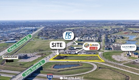
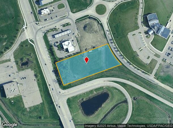
This Property Is For Sale
NEARBY LISTINGS FOR SALE OR LEASE
Property Detail
4001 28Th Ave S
Other Market Areas
Horizon Shores Holiday Addn
Fargo, ND-MN
BLOCK 001 LOT 002 PLATNUMBER PLATSUFFIX SUBDIVISIONCD 58331 SUBDIVISIONNAME HORIZON SHORES HOLIDAY ADDN SUBDIVPHASE
58.331.0020
Clay
Commercialnec
Minnesota
2025
2
2025
Fargo
020400
DEMOGRAPHICS near 4001 28Th Ave S
1 Mile
3 Mile
5 Mile
2024 Total Population
5,920
46,319
103,491
2029 Population
6,194
48,527
114,023
Pop Growth 2024-2029
+ 4.63%
+ 4.77%
+ 10.18%
Average Age
36
36
37
2024 Total Households
2,209
17,724
43,750
HH Growth 2024-2029
+ 4.93%
+ 5.18%
+ 11.27%
Median Household Inc
$85,000
$63,175
$58,440
Avg Household Size
2.60
2.40
2.20
2024 Avg HH Vehicles
2.00
2.00
2.00
Median Home Value
$271,201
$237,109
$229,051
Median Year Built
1999
1985
1975
Nearby Places
- Restaurants
- Banks
- Shops
- Fitness
- Groceries
PUBLIC TRANSPORTATION
COMMUTER RAIL
Fargo Amtrak Station (Empire Builder - Amtrak)
DRIVE
WALK
Distance
Fargo Amtrak Station (Empire Builder - Amtrak)
8 min
4.5 mi
AIRPORT
Hector International
DRIVE
WALK
Distance
Hector International
16 min
8.5 mi
Freight Ports
Port Milwaukee
DRIVE
WALK
Distance
Port Milwaukee
620 min
567.7 mi
Nearby Properties
Address
Land Use
TOTAL SIZE
Lot Size
Zoning
Address
Land Use
TOTAL SIZE
Lot Size
Zoning
40.49 AC
Address
Land Use
TOTAL SIZE
Lot Size
Zoning
30.61 AC
Address
Land Use
TOTAL SIZE
Lot Size
Zoning
Address
Land Use
TOTAL SIZE
Lot Size
Zoning
16.83 AC
Address
Land Use
TOTAL SIZE
Lot Size
Zoning
21.81 AC
Address
Land Use
TOTAL SIZE
Lot Size
Zoning
53.42 AC
Address
Land Use
TOTAL SIZE
Lot Size
Zoning
39.01 AC
Address
Land Use
TOTAL SIZE
Lot Size
Zoning
32.98 AC
Address
Land Use
TOTAL SIZE
Lot Size
Zoning
17.23 AC
Address
Land Use
TOTAL SIZE
Lot Size
Zoning
17.75 AC
Address
Land Use
TOTAL SIZE
Lot Size
Zoning
24.60 AC
Address
Land Use
TOTAL SIZE
Lot Size
Zoning
148.42 AC
Address
Land Use
TOTAL SIZE
Lot Size
Zoning
14.53 AC
Address
Land Use
TOTAL SIZE
Lot Size
Zoning
27.45 AC
Address
Land Use
TOTAL SIZE
Lot Size
Zoning
3.39 AC
Address
Land Use
TOTAL SIZE
Lot Size
Zoning
Address
Land Use
TOTAL SIZE
Lot Size
Zoning
2.77 AC
Address
Land Use
TOTAL SIZE
Lot Size
Zoning
7.82 AC
Address
Land Use
TOTAL SIZE
Lot Size
Zoning
0.22 AC
Address
Land Use
TOTAL SIZE
Lot Size
Zoning
999.99 AC
Address
Land Use
TOTAL SIZE
Lot Size
Zoning
0.17 AC
Address
Land Use
TOTAL SIZE
Lot Size
Zoning
4.90 AC
Address
Land Use
TOTAL SIZE
Lot Size
Zoning
189.14 AC
Address
Land Use
TOTAL SIZE
Lot Size
Zoning
2.91 AC
Address
Land Use
TOTAL SIZE
Lot Size
Zoning
6.02 AC
Address
Land Use
TOTAL SIZE
Lot Size
Zoning
2.07 AC
Address
Land Use
TOTAL SIZE
Lot Size
Zoning
6.99 AC
Address
Land Use
TOTAL SIZE
Lot Size
Zoning
9.04 AC
Address
Land Use
TOTAL SIZE
Lot Size
Zoning
10.41 AC
Address
Land Use
TOTAL SIZE
Lot Size
Zoning
15.42 AC
The World's #1 Commercial Real Estate Marketplace
Connect with us
© 2025 CoStar Group
The information above has been obtained from sources believed reliable. While we do not doubt its accuracy we have not verified it and make no guarantee, warranty or representation about it. It is your responsibility to independently confirm its accuracy and completeness. Any projections, opinions, assumptions, or estimates used are for example only and do not represent the current or future performance of the property. The value of this transaction to you depends on tax and other factors which should be evaluated by your tax, financial, and legal advisors. You and your advisors should conduct a careful, independent investigation of the property to determine to your satisfaction the suitability of the property for your needs.