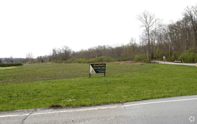
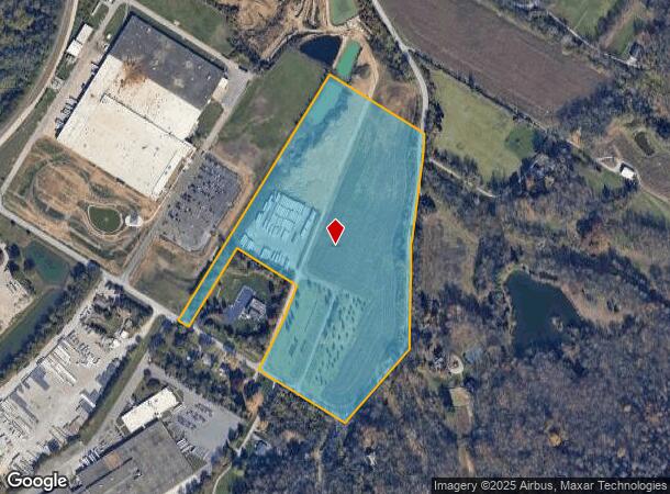
Property Record
8550 Broadwell Rd, Cincinnati, OH 45244
NEARBY LISTINGS FOR SALE OR LEASE
Property Detail
8550 Broadwell Rd
Cincinnati, OH-KY-IN
Military Surveys 706 & 1775
500-0081-0033
ES MT CARMEL RD 30.2592 ACS MS #706-1775
Farms
Hamilton
A
Ohio
39061C0268F
30.26 AC
2025
Eastgate/Anderson Twp
2025
Cincinnati/Dayton
024901
DEMOGRAPHICS near 8550 Broadwell Rd
1 mile
3 mile
5 mile
2024 Total Population
1,130
27,968
116,989
2029 Population
1,156
28,190
117,594
Pop Growth 2024-2029
+ 2.30%
+ 0.79%
+ 0.52%
Average Age
42
41
41
2024 Total Households
416
11,023
47,621
HH Growth 2024-2029
+ 2.40%
+ 1.07%
+ 0.71%
Median Household Inc
$111,818
$80,033
$78,453
Avg Household Size
2.70
2.50
2.40
2024 Avg HH Vehicles
2.00
2.00
2.00
Median Home Value
$299,999
$293,014
$259,724
Median Year Built
1989
1976
1975
Nearby Places
Map Layers
Map Styles
 Street
 Aerial
Transit
 Traffic
 Biking
Places
Listings with unknown addresses are not visible on the map
- Restaurants
- Banks
- Shops
- Fitness
- Groceries
PUBLIC TRANSPORTATION
AIRPORT
Cincinnati/Northern Kentucky International
Drive
Walk
Distance
Cincinnati/Northern Kentucky International
46 min
28.8 mi
SALE & LEASE HISTORY
LISTING DATE
SALE/LEASE

Apr 13, 2022
For Sale
Apr 07, 2017
For Sale
Nearby Properties
Address
Land Use
TOTAL SIZE
Lot Size
Zoning
Address
Land Use
TOTAL SIZE
Lot Size
Zoning
1,205 SF
41.47 AC
Address
Land Use
TOTAL SIZE
Lot Size
Zoning
25.51 AC
Address
Land Use
TOTAL SIZE
Lot Size
Zoning
49.27 AC
Address
Land Use
TOTAL SIZE
Lot Size
Zoning
1,134,029 SF
229.73 AC
Address
Land Use
TOTAL SIZE
Lot Size
Zoning
7.49 AC
Address
Land Use
TOTAL SIZE
Lot Size
Zoning
6.55 AC
Address
Land Use
TOTAL SIZE
Lot Size
Zoning
55,848 SF
12.51 AC
Address
Land Use
TOTAL SIZE
Lot Size
Zoning
27.01 AC
Address
Land Use
TOTAL SIZE
Lot Size
Zoning
220,050 SF
33 AC
Address
Land Use
TOTAL SIZE
Lot Size
Zoning
221,360 SF
34.62 AC
Address
Land Use
TOTAL SIZE
Lot Size
Zoning
49.66 AC
Address
Land Use
TOTAL SIZE
Lot Size
Zoning
10,452 SF
0.26 AC
CN-1-3
Address
Land Use
TOTAL SIZE
Lot Size
Zoning
9.59 AC
Address
Land Use
TOTAL SIZE
Lot Size
Zoning
396,288 SF
31.14 AC
Address
Land Use
TOTAL SIZE
Lot Size
Zoning
4,938 SF
18.99 AC
Address
Land Use
TOTAL SIZE
Lot Size
Zoning
75,944 SF
4.09 AC
Address
Land Use
TOTAL SIZE
Lot Size
Zoning
13.89 AC
Address
Land Use
TOTAL SIZE
Lot Size
Zoning
4,800 SF
3.41 AC
Address
Land Use
TOTAL SIZE
Lot Size
Zoning
62,823 SF
8.24 AC
Address
Land Use
TOTAL SIZE
Lot Size
Zoning
19,843 SF
4 AC
Address
Land Use
TOTAL SIZE
Lot Size
Zoning
32,024 SF
3.24 AC
Address
Land Use
TOTAL SIZE
Lot Size
Zoning
31,148 SF
1.96 AC
Address
Land Use
TOTAL SIZE
Lot Size
Zoning
74,252 SF
20.47 AC
Address
Land Use
TOTAL SIZE
Lot Size
Zoning
36,380 SF
5.45 AC
Address
Land Use
TOTAL SIZE
Lot Size
Zoning
102,891 SF
20.87 AC
Address
Land Use
TOTAL SIZE
Lot Size
Zoning
15,560 SF
37.03 AC
Address
Land Use
TOTAL SIZE
Lot Size
Zoning
14,223 SF
7.22 AC
Address
Land Use
TOTAL SIZE
Lot Size
Zoning
27,957 SF
29.54 AC
Address
Land Use
TOTAL SIZE
Lot Size
Zoning
14.28 AC
DD
Address
Land Use
TOTAL SIZE
Lot Size
Zoning
3,282 SF
1.47 AC
B
The World's #1 Commercial Real Estate Marketplace
Connect with us
© 2026 CoStar Group
The information above has been obtained from sources believed reliable. While we do not doubt its accuracy we have not verified it and make no guarantee, warranty or representation about it. It is your responsibility to independently confirm its accuracy and completeness. Any projections, opinions, assumptions, or estimates used are for example only and do not represent the current or future performance of the property. The value of this transaction to you depends on tax and other factors which should be evaluated by your tax, financial, and legal advisors. You and your advisors should conduct a careful, independent investigation of the property to determine to your satisfaction the suitability of the property for your needs.