Property Record
4001 Myra Way, Westfield, IN 46062
NEARBY LISTINGS FOR SALE OR LEASE
-
-
View all Westfield listings for sale on LoopNet.com
Property Detail
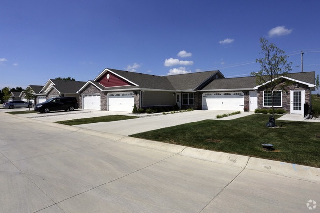
4001 Myra Way
29-06-32-024-007.000-015
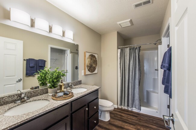
Redwood At Andover
Apartment
ACREAGE 2.43, SECTION 32, TOWNSHIP 19, RANGE 4, REDWOOD AT ANDOVER, REPLAT INFORMATION: REPLAT, BLOCK A-2, IRREGULAR SHAPE
X
Hamilton
18057C0136G
Indiana
2023
2.71 AC
2024
Noblesville/Durbin
110516
Indianapolis
31,248 SF
Indianapolis-Carmel-Anderson, IN
DEMOGRAPHICS near 4001 Myra Way
1 Mile
3 Mile
5 Mile
2024 Total Population
5,211
38,339
108,512
2029 Population
6,069
43,772
122,865
Pop Growth 2024-2029
+ 16.47%
+ 14.17%
+ 13.23%
Average Age
36
39
39
2024 Total Households
1,915
14,064
39,758
HH Growth 2024-2029
+ 16.40%
+ 14.16%
+ 13.20%
Median Household Inc
$75,398
$91,948
$95,606
Avg Household Size
2.70
2.70
2.70
2024 Avg HH Vehicles
2.00
2.00
2.00
Median Home Value
$257,499
$291,517
$329,407
Median Year Built
2006
2003
2001
Nearby Places
Map Layers
Map Styles
 Street
 Aerial
- Restaurants
- Banks
- Shops
- Fitness
- Groceries
PUBLIC TRANSPORTATION
AIRPORT
Indianapolis International
DRIVE
WALK
Distance
Indianapolis International
63 min
38.3 mi
Freight Ports
Port of Toledo
DRIVE
WALK
Distance
Port of Toledo
260 min
213.8 mi
Nearby Properties
Address
Land Use
TOTAL SIZE
Lot Size
Zoning
Address
Land Use
TOTAL SIZE
Lot Size
Zoning
27,385 SF
77.27 AC
Address
Land Use
TOTAL SIZE
Lot Size
Zoning
372,542 SF
32.10 AC
Address
Land Use
TOTAL SIZE
Lot Size
Zoning
328,692 SF
12 AC
Address
Land Use
TOTAL SIZE
Lot Size
Zoning
6.46 AC
Address
Land Use
TOTAL SIZE
Lot Size
Zoning
296,315 SF
17.65 AC
Address
Land Use
TOTAL SIZE
Lot Size
Zoning
97,726 SF
8.49 AC
Address
Land Use
TOTAL SIZE
Lot Size
Zoning
239,148 SF
18.56 AC
Address
Land Use
TOTAL SIZE
Lot Size
Zoning
370,914 SF
14.30 AC
Address
Land Use
TOTAL SIZE
Lot Size
Zoning
173,884 SF
14.07 AC
Address
Land Use
TOTAL SIZE
Lot Size
Zoning
203,619 SF
6.66 AC
Address
Land Use
TOTAL SIZE
Lot Size
Zoning
129,851 SF
42.03 AC
Address
Land Use
TOTAL SIZE
Lot Size
Zoning
153,602 SF
50.17 AC
Address
Land Use
TOTAL SIZE
Lot Size
Zoning
231,080 SF
9.28 AC
Address
Land Use
TOTAL SIZE
Lot Size
Zoning
73,680 SF
19.08 AC
Address
Land Use
TOTAL SIZE
Lot Size
Zoning
314,499 SF
12 AC
Address
Land Use
TOTAL SIZE
Lot Size
Zoning
290,862 SF
2.54 AC
Address
Land Use
TOTAL SIZE
Lot Size
Zoning
120,584 SF
20 AC
Address
Land Use
TOTAL SIZE
Lot Size
Zoning
282,022 SF
7.65 AC
Address
Land Use
TOTAL SIZE
Lot Size
Zoning
183,536 SF
13.34 AC
Address
Land Use
TOTAL SIZE
Lot Size
Zoning
300,782 SF
53.87 AC
Address
Land Use
TOTAL SIZE
Lot Size
Zoning
65,466 SF
7 AC
Address
Land Use
TOTAL SIZE
Lot Size
Zoning
101,050 SF
62.43 AC
Address
Land Use
TOTAL SIZE
Lot Size
Zoning
139,190 SF
12.06 AC
Address
Land Use
TOTAL SIZE
Lot Size
Zoning
265,084 SF
22.35 AC
Address
Land Use
TOTAL SIZE
Lot Size
Zoning
77,790 SF
3.77 AC
Address
Land Use
TOTAL SIZE
Lot Size
Zoning
133,160 SF
7.91 AC
Address
Land Use
TOTAL SIZE
Lot Size
Zoning
17,678 SF
53.27 AC
Address
Land Use
TOTAL SIZE
Lot Size
Zoning
103,984 SF
3.91 AC
Address
Land Use
TOTAL SIZE
Lot Size
Zoning
99,704 SF
12.27 AC
Address
Land Use
TOTAL SIZE
Lot Size
Zoning
203,763 SF
20.39 AC
The World's #1 Commercial Real Estate Marketplace
Connect with us
© 2026 CoStar Group
The information above has been obtained from sources believed reliable. While we do not doubt its accuracy we have not verified it and make no guarantee, warranty or representation about it. It is your responsibility to independently confirm its accuracy and completeness. Any projections, opinions, assumptions, or estimates used are for example only and do not represent the current or future performance of the property. The value of this transaction to you depends on tax and other factors which should be evaluated by your tax, financial, and legal advisors. You and your advisors should conduct a careful, independent investigation of the property to determine to your satisfaction the suitability of the property for your needs.