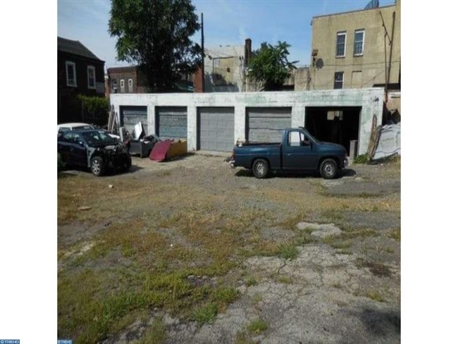
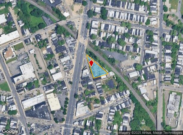
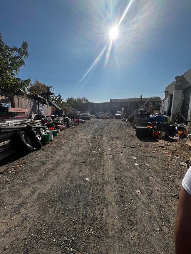
Property Record
4001 N Broad St, Philadelphia, PA 19140
NEARBY LISTINGS FOR SALE OR LEASE
Property Detail
4001 N Broad St
882965140
NEC DELL ST
Autorepair
Philadelphia
X
Pennsylvania
42091C0395G
407
2024
0.45 AC
2026
Lower North Philly
020300
Philadelphia
3,509 SF
Philadelphia-Camden-Wilmington, PA-NJ-DE-MD
DEMOGRAPHICS near 4001 N Broad St
1 Mile
3 Mile
5 Mile
2024 Total Population
49,745
442,848
969,729
2029 Population
48,287
432,787
946,674
Pop Growth 2024-2029
(2.93%)
(2.27%)
(2.38%)
Average Age
38
37
38
2024 Total Households
18,854
169,464
401,521
HH Growth 2024-2029
(3.08%)
(2.40%)
(2.51%)
Median Household Inc
$30,093
$35,936
$52,313
Avg Household Size
2.50
2.40
2.30
2024 Avg HH Vehicles
1.00
1.00
1.00
Median Home Value
$87,299
$147,312
$211,966
Median Year Built
1946
1947
1949
Nearby Places
Map Layers
Map Styles
 Street
 Aerial
- Restaurants
- Banks
- Shops
- Fitness
- Groceries
PUBLIC TRANSPORTATION
TRANSIT/SUBWAY
Hunting Park (Broad Street Line - Southeastern Pennsylvania Transportation Authority Rapid Transit (SEPTA Subway & Trolley))
DRIVE
WALK
Distance
Hunting Park (Broad Street Line - Southeastern Pennsylvania Transportation Authority Rapid Transit (SEPTA Subway & Trolley))
1 min
5 min
0.3 mi
Erie (Broad Street Line - Southeastern Pennsylvania Transportation Authority Rapid Transit (SEPTA Subway & Trolley))
DRIVE
WALK
Distance
Erie (Broad Street Line - Southeastern Pennsylvania Transportation Authority Rapid Transit (SEPTA Subway & Trolley))
1 min
7 min
0.4 mi
Wyoming (Broad Street Line - Southeastern Pennsylvania Transportation Authority Rapid Transit (SEPTA Subway & Trolley))
DRIVE
WALK
Distance
Wyoming (Broad Street Line - Southeastern Pennsylvania Transportation Authority Rapid Transit (SEPTA Subway & Trolley))
2 min
14 min
0.7 mi
Allegheny (Bss) (Broad Street Line - SEPTA)
DRIVE
WALK
Distance
Allegheny (Bss) (Broad Street Line - SEPTA)
2 min
17 min
0.9 mi
COMMUTER RAIL
Wayne Junction (R1 - Southeastern Pennsylvania Transportation Authority Regional Rail (SEPTA Regional Rail), R2 - Southeastern Pennsylvania Transportation Authority Regional Rail (SEPTA Regional Rail), R3 - Southeastern Pennsylvania Transportation Authority Regional Rail (SEPTA Regional Rail), R5 - Southeastern Pennsylvania Transportation Authority Regional Rail (SEPTA Regional Rail), R7 - Southeastern Pennsylvania Transportation Authority Regional Rail (SEPTA Regional Rail), R8 - Southeastern Pennsylvania Transportation Authority Regional Rail (SEPTA Regional Rail))
DRIVE
WALK
Distance
Wayne Junction (R1 - Southeastern Pennsylvania Transportation Authority Regional Rail (SEPTA Regional Rail), R2 - Southeastern Pennsylvania Transportation Authority Regional Rail (SEPTA Regional Rail), R3 - Southeastern Pennsylvania Transportation Authority Regional Rail (SEPTA Regional Rail), R5 - Southeastern Pennsylvania Transportation Authority Regional Rail (SEPTA Regional Rail), R7 - Southeastern Pennsylvania Transportation Authority Regional Rail (SEPTA Regional Rail), R8 - Southeastern Pennsylvania Transportation Authority Regional Rail (SEPTA Regional Rail))
2 min
18 min
1.0 mi
Allegheny (R6 - Southeastern Pennsylvania Transportation Authority Regional Rail (SEPTA Regional Rail))
DRIVE
WALK
Distance
Allegheny (R6 - Southeastern Pennsylvania Transportation Authority Regional Rail (SEPTA Regional Rail))
4 min
1.6 mi
AIRPORT
Philadelphia International
DRIVE
WALK
Distance
Philadelphia International
30 min
16.8 mi
Trenton Mercer
DRIVE
WALK
Distance
Trenton Mercer
49 min
28.9 mi
Freight Ports
Port of Philadelphia
DRIVE
WALK
Distance
Port of Philadelphia
11 min
5.6 mi
SALE & LEASE HISTORY
LISTING DATE
SALE/LEASE

Sep 24, 2018
For Sale
Oct 23, 2024
For Sale
Nearby Properties
Address
Land Use
TOTAL SIZE
Lot Size
Zoning
Address
Land Use
TOTAL SIZE
Lot Size
Zoning
1.88 AC
SPINS
Address
Land Use
TOTAL SIZE
Lot Size
Zoning
461,286 SF
2.64 AC
CMX4
Address
Land Use
TOTAL SIZE
Lot Size
Zoning
500,875 SF
4.31 AC
RM1
Address
Land Use
TOTAL SIZE
Lot Size
Zoning
455,889 SF
33 AC
I2
Address
Land Use
TOTAL SIZE
Lot Size
Zoning
285,615 SF
1.46 AC
SPINS
Address
Land Use
TOTAL SIZE
Lot Size
Zoning
520,280 SF
14.84 AC
RM3
Address
Land Use
TOTAL SIZE
Lot Size
Zoning
254,947 SF
1.73 AC
CMX4
Address
Land Use
TOTAL SIZE
Lot Size
Zoning
96,574 SF
2.42 AC
RM2
Address
Land Use
TOTAL SIZE
Lot Size
Zoning
22,648 SF
38.69 AC
RM3
Address
Land Use
TOTAL SIZE
Lot Size
Zoning
485,616 SF
8.96 AC
CMX3
Address
Land Use
TOTAL SIZE
Lot Size
Zoning
242,655 SF
3.29 AC
CMX3
Address
Land Use
TOTAL SIZE
Lot Size
Zoning
425,535 SF
4.60 AC
RM3
Address
Land Use
TOTAL SIZE
Lot Size
Zoning
3,590 SF
50 AC
SPPOA
Address
Land Use
TOTAL SIZE
Lot Size
Zoning
121,578 SF
3.13 AC
RSA3
Address
Land Use
TOTAL SIZE
Lot Size
Zoning
324,477 SF
1.99 AC
CMX4
Address
Land Use
TOTAL SIZE
Lot Size
Zoning
587,330 SF
34.37 AC
SPINS
Address
Land Use
TOTAL SIZE
Lot Size
Zoning
287,286 SF
1.26 AC
CMX5
Address
Land Use
TOTAL SIZE
Lot Size
Zoning
293,510 SF
7.03 AC
SPINS
Address
Land Use
TOTAL SIZE
Lot Size
Zoning
17,886 SF
80 AC
SPPOA
Address
Land Use
TOTAL SIZE
Lot Size
Zoning
390,773 SF
2.86 AC
CMX3
Address
Land Use
TOTAL SIZE
Lot Size
Zoning
164,412 SF
4.44 AC
SPINS
Address
Land Use
TOTAL SIZE
Lot Size
Zoning
495,017 SF
9.65 AC
CMX3
Address
Land Use
TOTAL SIZE
Lot Size
Zoning
234,684 SF
0.45 AC
CMX4
Address
Land Use
TOTAL SIZE
Lot Size
Zoning
829,504 SF
4.77 AC
SPINS
Address
Land Use
TOTAL SIZE
Lot Size
Zoning
128,164 SF
6.82 AC
SPINS
Address
Land Use
TOTAL SIZE
Lot Size
Zoning
218,960 SF
1.55 AC
RM2
Address
Land Use
TOTAL SIZE
Lot Size
Zoning
210,738 SF
8.73 AC
RM4
Address
Land Use
TOTAL SIZE
Lot Size
Zoning
504,972 SF
16.30 AC
RM2
Address
Land Use
TOTAL SIZE
Lot Size
Zoning
425,000 SF
2.08 AC
SPINS
Address
Land Use
TOTAL SIZE
Lot Size
Zoning
500,000 SF
2.30 AC
CMX3
The World's #1 Commercial Real Estate Marketplace
Connect with us
© 2025 CoStar Group
The information above has been obtained from sources believed reliable. While we do not doubt its accuracy we have not verified it and make no guarantee, warranty or representation about it. It is your responsibility to independently confirm its accuracy and completeness. Any projections, opinions, assumptions, or estimates used are for example only and do not represent the current or future performance of the property. The value of this transaction to you depends on tax and other factors which should be evaluated by your tax, financial, and legal advisors. You and your advisors should conduct a careful, independent investigation of the property to determine to your satisfaction the suitability of the property for your needs.