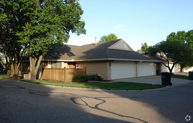
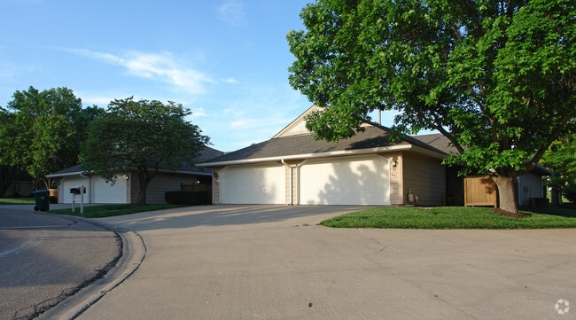
Property Record
4001 Parkway Cir, Lawrence, KS 66047

NEARBY LISTINGS FOR SALE OR LEASE
-
-
View all Lawrence listings for sale on LoopNet.com
Property Detail
4001 Parkway Cir
Lawrence, KS
Subdivision 0665
023-112-03-0-30-03-016.01-0
GOLF CLUB NO 3 SUB A REPLAT OFLOT 1 GOLF CLUB SUB LT 1A
Gardenaptcourtapt5plusunits
Douglas
AE
Kansas
20045C0158D
1,1a
2024
8.15 AC
2025
South Lawrence
000797
Kansas City
23,082 SF
DEMOGRAPHICS near 4001 Parkway Cir
1 Mile
3 Mile
5 Mile
2024 Total Population
10,641
70,495
99,683
2029 Population
10,804
71,898
101,741
Pop Growth 2024-2029
+ 1.53%
+ 1.99%
+ 2.06%
Average Age
37
35
36
2024 Total Households
4,826
29,293
41,660
HH Growth 2024-2029
+ 1.57%
+ 2.20%
+ 2.24%
Median Household Inc
$54,703
$52,740
$55,324
Avg Household Size
2.20
2.10
2.20
2024 Avg HH Vehicles
2.00
2.00
2.00
Median Home Value
$255,078
$269,760
$240,876
Median Year Built
1993
1989
1988
Nearby Places
Map Layers
Map Styles
 Street
 Aerial
- Restaurants
- Banks
- Shops
- Fitness
- Groceries
PUBLIC TRANSPORTATION
COMMUTER RAIL
Lawrence Amtrak Station (Southwest Chief - Amtrak)
DRIVE
WALK
Distance
Lawrence Amtrak Station (Southwest Chief - Amtrak)
10 min
5.5 mi
Freight Ports
Tulsa Port Of Catoosa
DRIVE
WALK
Distance
Tulsa Port Of Catoosa
254 min
212.2 mi
Nearby Properties
Address
Land Use
TOTAL SIZE
Lot Size
Zoning
Address
Land Use
TOTAL SIZE
Lot Size
Zoning
1,709,524 SF
32.03 AC
RD
Address
Land Use
TOTAL SIZE
Lot Size
Zoning
1,258,819 SF
106.65 AC
RD
Address
Land Use
TOTAL SIZE
Lot Size
Zoning
1,264,810 SF
129.10 AC
RD
Address
Land Use
TOTAL SIZE
Lot Size
Zoning
335,349 SF
3.17 AC
RD
Address
Land Use
TOTAL SIZE
Lot Size
Zoning
112,168 SF
38.08 AC
RD
Address
Land Use
TOTAL SIZE
Lot Size
Zoning
200,960 SF
9.20 AC
RD
Address
Land Use
TOTAL SIZE
Lot Size
Zoning
190,168 SF
55.04 AC
C2
Address
Land Use
TOTAL SIZE
Lot Size
Zoning
249,773 SF
34.84 AC
RS2
Address
Land Use
TOTAL SIZE
Lot Size
Zoning
336,701 SF
5.20 AC
RD
Address
Land Use
TOTAL SIZE
Lot Size
Zoning
220,557 SF
8.90 AC
RD
Address
Land Use
TOTAL SIZE
Lot Size
Zoning
162,086 SF
3 AC
RD
Address
Land Use
TOTAL SIZE
Lot Size
Zoning
143,279 SF
36.20 AC
RS1
Address
Land Use
TOTAL SIZE
Lot Size
Zoning
181,346 SF
21.40 AC
497
Address
Land Use
TOTAL SIZE
Lot Size
Zoning
186,889 SF
3.60 AC
RD
Address
Land Use
TOTAL SIZE
Lot Size
Zoning
92,295 SF
10.40 AC
RS1
Address
Land Use
TOTAL SIZE
Lot Size
Zoning
11,992 SF
118.15 AC
RS1
Address
Land Use
TOTAL SIZE
Lot Size
Zoning
125,214 SF
20 AC
RS1
Address
Land Use
TOTAL SIZE
Lot Size
Zoning
104,785 SF
105.60 AC
RS1
Address
Land Use
TOTAL SIZE
Lot Size
Zoning
1,034 SF
254.80 AC
AG
Address
Land Use
TOTAL SIZE
Lot Size
Zoning
56,172 SF
14.05 AC
AG
Address
Land Use
TOTAL SIZE
Lot Size
Zoning
92,819 SF
3.10 AC
RO2
Address
Land Use
TOTAL SIZE
Lot Size
Zoning
55,556 SF
24.90 AC
RM1
Address
Land Use
TOTAL SIZE
Lot Size
Zoning
52,000 SF
36 AC
RS1
Address
Land Use
TOTAL SIZE
Lot Size
Zoning
19,985 SF
103.37 AC
RS1
Address
Land Use
TOTAL SIZE
Lot Size
Zoning
337,280 SF
0.60 AC
RD
Address
Land Use
TOTAL SIZE
Lot Size
Zoning
55,275 SF
12.30 AC
AG
Address
Land Use
TOTAL SIZE
Lot Size
Zoning
79,784 SF
3.46 AC
RM2
Address
Land Use
TOTAL SIZE
Lot Size
Zoning
51,366 SF
15 AC
RS2
Address
Land Use
TOTAL SIZE
Lot Size
Zoning
22,774 SF
3.49 AC
RD
Address
Land Use
TOTAL SIZE
Lot Size
Zoning
40,349 SF
5.02 AC
C2
The World's #1 Commercial Real Estate Marketplace
Connect with us
© 2025 CoStar Group
The information above has been obtained from sources believed reliable. While we do not doubt its accuracy we have not verified it and make no guarantee, warranty or representation about it. It is your responsibility to independently confirm its accuracy and completeness. Any projections, opinions, assumptions, or estimates used are for example only and do not represent the current or future performance of the property. The value of this transaction to you depends on tax and other factors which should be evaluated by your tax, financial, and legal advisors. You and your advisors should conduct a careful, independent investigation of the property to determine to your satisfaction the suitability of the property for your needs.