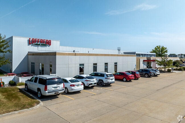
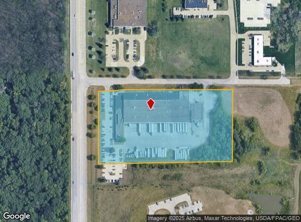
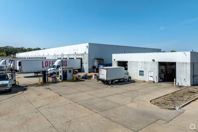
Property Record
4001 Sw 63Rd St, Des Moines, IA 50321
NEARBY LISTINGS FOR SALE OR LEASE
Property Detail
4001 Sw 63Rd St
Des Moines-West Des Moines, IA
Airport Commerce Park Plat 1
120-00006055000
LT 5 AIRPORT INDUSTRIAL PARK PLAT 1
Warehouse
Polk
X
Iowa
19153C0340F
5
2024
7.95 AC
2025
South
004004
Des Moines
84,464 SF
DEMOGRAPHICS near 4001 Sw 63Rd St
1 Mile
3 Mile
5 Mile
2024 Total Population
1,454
28,771
153,853
2029 Population
1,577
30,062
160,819
Pop Growth 2024-2029
+ 8.46%
+ 4.49%
+ 4.53%
Average Age
37
40
39
2024 Total Households
574
12,425
67,865
HH Growth 2024-2029
+ 8.36%
+ 4.55%
+ 4.75%
Median Household Inc
$81,500
$78,016
$68,669
Avg Household Size
2.40
2.30
2.20
2024 Avg HH Vehicles
2.00
2.00
2.00
Median Home Value
$293,420
$270,693
$217,741
Median Year Built
1998
1975
1972
Nearby Places
Map Layers
Map Styles
 Street
 Aerial
- Restaurants
- Banks
- Shops
- Fitness
- Groceries
PUBLIC TRANSPORTATION
AIRPORT
Des Moines International
DRIVE
WALK
Distance
Des Moines International
9 min
3.8 mi
Freight Ports
Port Milwaukee
DRIVE
WALK
Distance
Port Milwaukee
427 min
380.8 mi
Nearby Properties
Address
Land Use
TOTAL SIZE
Lot Size
Zoning
Address
Land Use
TOTAL SIZE
Lot Size
Zoning
351,427 SF
57.41 AC
Address
Land Use
TOTAL SIZE
Lot Size
Zoning
496,782 SF
59.32 AC
Address
Land Use
TOTAL SIZE
Lot Size
Zoning
283,760 SF
27.19 AC
Address
Land Use
TOTAL SIZE
Lot Size
Zoning
283,760 SF
14.96 AC
Address
Land Use
TOTAL SIZE
Lot Size
Zoning
227,640 SF
19.48 AC
Address
Land Use
TOTAL SIZE
Lot Size
Zoning
Address
Land Use
TOTAL SIZE
Lot Size
Zoning
397,938 SF
27.97 AC
PUD
Address
Land Use
TOTAL SIZE
Lot Size
Zoning
302,800 SF
20.85 AC
Address
Land Use
TOTAL SIZE
Lot Size
Zoning
444,073 SF
28.05 AC
RH
Address
Land Use
TOTAL SIZE
Lot Size
Zoning
203,710 SF
26.88 AC
Address
Land Use
TOTAL SIZE
Lot Size
Zoning
150,640 SF
2.46 AC
PUD
Address
Land Use
TOTAL SIZE
Lot Size
Zoning
235,620 SF
13.18 AC
RH
Address
Land Use
TOTAL SIZE
Lot Size
Zoning
175,021 SF
6.76 AC
Address
Land Use
TOTAL SIZE
Lot Size
Zoning
526,295 SF
26.06 AC
M-1
Address
Land Use
TOTAL SIZE
Lot Size
Zoning
192,222 SF
9.27 AC
Address
Land Use
TOTAL SIZE
Lot Size
Zoning
189,506 SF
11.78 AC
PUD HD
Address
Land Use
TOTAL SIZE
Lot Size
Zoning
168,556 SF
10.92 AC
RH
Address
Land Use
TOTAL SIZE
Lot Size
Zoning
161,788 SF
9.41 AC
PBP
Address
Land Use
TOTAL SIZE
Lot Size
Zoning
61,320 SF
8.13 AC
Address
Land Use
TOTAL SIZE
Lot Size
Zoning
264,656 SF
9.38 AC
RH
Address
Land Use
TOTAL SIZE
Lot Size
Zoning
96,860 SF
7.98 AC
R-1
Address
Land Use
TOTAL SIZE
Lot Size
Zoning
191,668 SF
8.27 AC
R-6
Address
Land Use
TOTAL SIZE
Lot Size
Zoning
149,564 SF
22.29 AC
PUD
Address
Land Use
TOTAL SIZE
Lot Size
Zoning
107,810 SF
9.63 AC
PUD MD
Address
Land Use
TOTAL SIZE
Lot Size
Zoning
135,016 SF
25.08 AC
M-1
Address
Land Use
TOTAL SIZE
Lot Size
Zoning
205,224 SF
9.21 AC
Address
Land Use
TOTAL SIZE
Lot Size
Zoning
99,300 SF
5.15 AC
GI
Address
Land Use
TOTAL SIZE
Lot Size
Zoning
48,424 SF
2.08 AC
SC
Address
Land Use
TOTAL SIZE
Lot Size
Zoning
38,950 SF
9.99 AC
RM
Address
Land Use
TOTAL SIZE
Lot Size
Zoning
207,624 SF
8.35 AC
The World's #1 Commercial Real Estate Marketplace
Connect with us
© 2026 CoStar Group
The information above has been obtained from sources believed reliable. While we do not doubt its accuracy we have not verified it and make no guarantee, warranty or representation about it. It is your responsibility to independently confirm its accuracy and completeness. Any projections, opinions, assumptions, or estimates used are for example only and do not represent the current or future performance of the property. The value of this transaction to you depends on tax and other factors which should be evaluated by your tax, financial, and legal advisors. You and your advisors should conduct a careful, independent investigation of the property to determine to your satisfaction the suitability of the property for your needs.