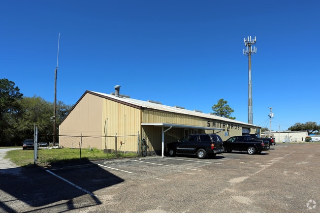
Property Record
4001 N W St, Pensacola, FL 32505


Current Lease Availabilities
NEARBY LISTINGS FOR SALE OR LEASE
Property Detail
4001 N W St
Pensacola-Ferry Pass-Brent, FL
Bell Acres
09-2S-30-0900-040-005
LTS 4 & 5 BLK 5 BELL ACRES PB 2 P 10 OR 9312 P 1883 LESS OR 976 P 735 STATE RD W ST R/W
Vehiclerentalsvehiclesales
Escambia
X
Florida
12033C0360G
40
2024
1.29 AC
2025
West Pensacola
001700
Pensacola
8,820 SF
DEMOGRAPHICS near 4001 N W St
1 Mile
3 Mile
5 Mile
2024 Total Population
7,915
72,415
159,499
2029 Population
8,229
74,359
162,984
Pop Growth 2024-2029
+ 3.97%
+ 2.68%
+ 2.18%
Average Age
35
37
39
2024 Total Households
2,889
27,128
64,173
HH Growth 2024-2029
+ 4.12%
+ 2.79%
+ 2.23%
Median Household Inc
$33,131
$39,354
$46,466
Avg Household Size
2.60
2.30
2.30
2024 Avg HH Vehicles
1.00
2.00
2.00
Median Home Value
$68,473
$137,836
$172,763
Median Year Built
1973
1971
1974
Nearby Places
Map Layers
Map Styles
 Street
 Aerial
- Restaurants
- Banks
- Shops
- Fitness
- Groceries
PUBLIC TRANSPORTATION
AIRPORT
Pensacola International
DRIVE
WALK
Distance
Pensacola International
12 min
5.1 mi
Freight Ports
Port of Mobile
DRIVE
WALK
Distance
Port of Mobile
65 min
54.9 mi
Nearby Properties
Address
Land Use
TOTAL SIZE
Lot Size
Zoning
Address
Land Use
TOTAL SIZE
Lot Size
Zoning
1,487,006 SF
39.92 AC
C-1
Address
Land Use
TOTAL SIZE
Lot Size
Zoning
820,379 SF
52.64 AC
C-3
Address
Land Use
TOTAL SIZE
Lot Size
Zoning
1,479,067 SF
77.37 AC
COM
Address
Land Use
TOTAL SIZE
Lot Size
Zoning
305,650 SF
21.90 AC
HDMU
Address
Land Use
TOTAL SIZE
Lot Size
Zoning
210,644 SF
13.14 AC
R-2
Address
Land Use
TOTAL SIZE
Lot Size
Zoning
289,397 SF
12.38 AC
PUB
Address
Land Use
TOTAL SIZE
Lot Size
Zoning
250,232 SF
19.24 AC
HDR
Address
Land Use
TOTAL SIZE
Lot Size
Zoning
197,545 SF
8.60 AC
R-2A
Address
Land Use
TOTAL SIZE
Lot Size
Zoning
171,830 SF
1.20 AC
C-1
Address
Land Use
TOTAL SIZE
Lot Size
Zoning
485,500 SF
15.92 AC
COM
Address
Land Use
TOTAL SIZE
Lot Size
Zoning
258,438 SF
48.49 AC
PUB
Address
Land Use
TOTAL SIZE
Lot Size
Zoning
282,738 SF
14.64 AC
PUB
Address
Land Use
TOTAL SIZE
Lot Size
Zoning
169,963 SF
15.43 AC
HC/LI
Address
Land Use
TOTAL SIZE
Lot Size
Zoning
107,722 SF
2.84 AC
COM
Address
Land Use
TOTAL SIZE
Lot Size
Zoning
130,830 SF
26.30 AC
M-2
Address
Land Use
TOTAL SIZE
Lot Size
Zoning
290,850 SF
11.15 AC
C-2
Address
Land Use
TOTAL SIZE
Lot Size
Zoning
83,923 SF
6.70 AC
HC/LI
Address
Land Use
TOTAL SIZE
Lot Size
Zoning
126,328 SF
7.44 AC
C-1,R-2A
Address
Land Use
TOTAL SIZE
Lot Size
Zoning
76,703 SF
7.01 AC
C-1,R-1AA
Address
Land Use
TOTAL SIZE
Lot Size
Zoning
171,446 SF
14.83 AC
R-2A
Address
Land Use
TOTAL SIZE
Lot Size
Zoning
130,516 SF
4.55 AC
R-2
Address
Land Use
TOTAL SIZE
Lot Size
Zoning
62,941 SF
6.73 AC
C-1
Address
Land Use
TOTAL SIZE
Lot Size
Zoning
123,485 SF
0.69 AC
C-1
Address
Land Use
TOTAL SIZE
Lot Size
Zoning
164,852 SF
2.40 AC
COM
Address
Land Use
TOTAL SIZE
Lot Size
Zoning
131,408 SF
21.67 AC
HC/LI
Address
Land Use
TOTAL SIZE
Lot Size
Zoning
87,795 SF
1.55 AC
C-1
Address
Land Use
TOTAL SIZE
Lot Size
Zoning
197,958 SF
26.08 AC
COM
Address
Land Use
TOTAL SIZE
Lot Size
Zoning
129,532 SF
10.84 AC
COM
Address
Land Use
TOTAL SIZE
Lot Size
Zoning
80,319 SF
2.41 AC
C-1
Address
Land Use
TOTAL SIZE
Lot Size
Zoning
254,937 SF
39.66 AC
R-1AA
The World's #1 Commercial Real Estate Marketplace
Connect with us
© 2026 CoStar Group
The information above has been obtained from sources believed reliable. While we do not doubt its accuracy we have not verified it and make no guarantee, warranty or representation about it. It is your responsibility to independently confirm its accuracy and completeness. Any projections, opinions, assumptions, or estimates used are for example only and do not represent the current or future performance of the property. The value of this transaction to you depends on tax and other factors which should be evaluated by your tax, financial, and legal advisors. You and your advisors should conduct a careful, independent investigation of the property to determine to your satisfaction the suitability of the property for your needs.