Property Record
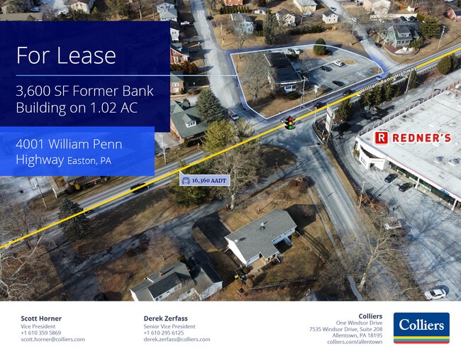
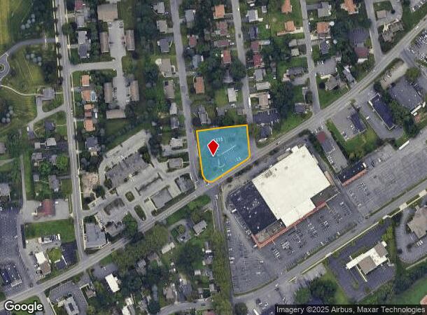
4001 William Penn Hwy, Easton, PA 18045
Current Lease Availabilities
NEARBY LISTINGS FOR SALE OR LEASE
Property Detail
4001 William Penn Hwy
M8NE4-4-11-0324
Woodmont
Financialbuilding
Northampton
X
Pennsylvania
42095C0267E
1.02 AC
2025
Lehigh Valley
2025
Philadelphia
017501
Allentown-Bethlehem-Easton, PA-NJ
3,600 SF
DEMOGRAPHICS near 4001 William Penn Hwy
1 Mile
3 Mile
5 Mile
2024 Total Population
8,570
60,568
144,428
2029 Population
8,603
60,865
145,469
Pop Growth 2024-2029
+ 0.39%
+ 0.49%
+ 0.72%
Average Age
45
41
41
2024 Total Households
3,362
22,277
54,353
HH Growth 2024-2029
+ 0.33%
+ 0.44%
+ 0.74%
Median Household Inc
$92,795
$87,837
$84,456
Avg Household Size
2.40
2.50
2.50
2024 Avg HH Vehicles
2.00
2.00
2.00
Median Home Value
$265,426
$254,019
$258,806
Median Year Built
1974
1968
1970
Nearby Places
- Restaurants
- Banks
- Shops
- Fitness
- Groceries
PUBLIC TRANSPORTATION
AIRPORT
Lehigh Valley International
DRIVE
WALK
Distance
Lehigh Valley International
21 min
12.5 mi
Freight Ports
Port of Philadelphia
DRIVE
WALK
Distance
Port of Philadelphia
96 min
59.4 mi
Nearby Properties
Address
Land Use
TOTAL SIZE
Lot Size
Zoning
Address
Land Use
TOTAL SIZE
Lot Size
Zoning
148,804 SF
22.75 AC
OB
Address
Land Use
TOTAL SIZE
Lot Size
Zoning
52,164 SF
124.81 AC
IN
Address
Land Use
TOTAL SIZE
Lot Size
Zoning
84,805 SF
12.20 AC
CHDD
Address
Land Use
TOTAL SIZE
Lot Size
Zoning
56,276 SF
14.91 AC
RR
Address
Land Use
TOTAL SIZE
Lot Size
Zoning
162,960 SF
16.26 AC
HDR
Address
Land Use
TOTAL SIZE
Lot Size
Zoning
176,397 SF
45.38 AC
HI
Address
Land Use
TOTAL SIZE
Lot Size
Zoning
26,714 SF
33.71 AC
RI
Address
Land Use
TOTAL SIZE
Lot Size
Zoning
430,201 SF
17.30 AC
I
Address
Land Use
TOTAL SIZE
Lot Size
Zoning
56,276 SF
6.94 AC
RR
Address
Land Use
TOTAL SIZE
Lot Size
Zoning
107,028 SF
3.31 AC
R2
Address
Land Use
TOTAL SIZE
Lot Size
Zoning
319,578 SF
27.91 AC
I
Address
Land Use
TOTAL SIZE
Lot Size
Zoning
137,060 SF
16.16 AC
OB
Address
Land Use
TOTAL SIZE
Lot Size
Zoning
3,055 SF
7.06 AC
OB
Address
Land Use
TOTAL SIZE
Lot Size
Zoning
97,066 SF
14.02 AC
MDB
Address
Land Use
TOTAL SIZE
Lot Size
Zoning
59,583 SF
3.87 AC
C
Address
Land Use
TOTAL SIZE
Lot Size
Zoning
35,575 SF
35.21 AC
C
Address
Land Use
TOTAL SIZE
Lot Size
Zoning
73,506 SF
6.32 AC
OB
Address
Land Use
TOTAL SIZE
Lot Size
Zoning
56,276 SF
4.91 AC
RR
Address
Land Use
TOTAL SIZE
Lot Size
Zoning
94,967 SF
29.12 AC
HI
Address
Land Use
TOTAL SIZE
Lot Size
Zoning
77,178 SF
16.19 AC
GC
Address
Land Use
TOTAL SIZE
Lot Size
Zoning
39,772 SF
6.02 AC
CR
Address
Land Use
TOTAL SIZE
Lot Size
Zoning
183,401 SF
10.71 AC
OB
Address
Land Use
TOTAL SIZE
Lot Size
Zoning
57,188 SF
23.88 AC
LI
Address
Land Use
TOTAL SIZE
Lot Size
Zoning
73,622 SF
10.67 AC
RR
Address
Land Use
TOTAL SIZE
Lot Size
Zoning
47,585 SF
3.74 AC
OB
Address
Land Use
TOTAL SIZE
Lot Size
Zoning
184,061 SF
25.75 AC
I
Address
Land Use
TOTAL SIZE
Lot Size
Zoning
21,920 SF
60.95 AC
IN
Address
Land Use
TOTAL SIZE
Lot Size
Zoning
66,375 SF
5.36 AC
OB
Address
Land Use
TOTAL SIZE
Lot Size
Zoning
156,202 SF
1.25 AC
R2
Address
Land Use
TOTAL SIZE
Lot Size
Zoning
57,652 SF
6.36 AC
PIC
The World's #1 Commercial Real Estate Marketplace
Connect with us
© 2025 CoStar Group
The information above has been obtained from sources believed reliable. While we do not doubt its accuracy we have not verified it and make no guarantee, warranty or representation about it. It is your responsibility to independently confirm its accuracy and completeness. Any projections, opinions, assumptions, or estimates used are for example only and do not represent the current or future performance of the property. The value of this transaction to you depends on tax and other factors which should be evaluated by your tax, financial, and legal advisors. You and your advisors should conduct a careful, independent investigation of the property to determine to your satisfaction the suitability of the property for your needs.