Property Record
4002 N 67Th Ave, Phoenix, AZ 85033
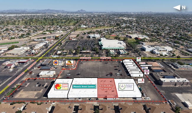

Current Lease Availabilities
NEARBY LISTINGS FOR SALE OR LEASE
Property Detail
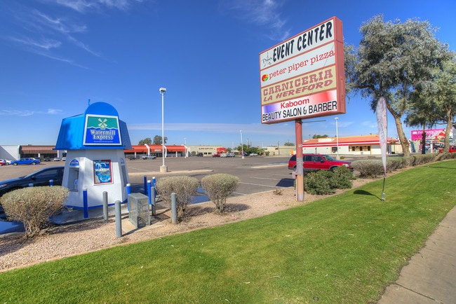
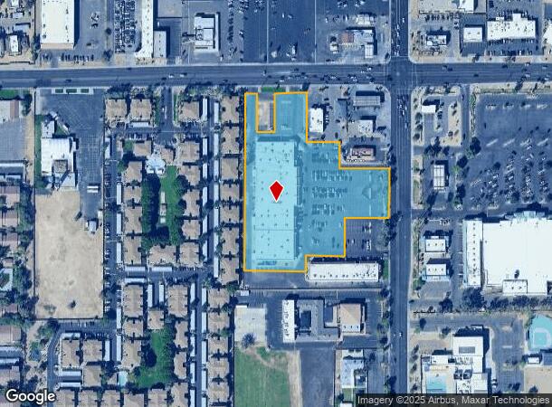
4002 N 67Th Ave
Phoenix-Mesa-Scottsdale, AZ
Furr Village Too
102-21-418A
FURR VILLAGE TOO MCR 210-34
Regionalshoppingcenterormallwithanchorstore
Maricopa
X
Arizona
04013C2180L
2
2025
6.22 AC
2025
West Phoenix/Maryvale
109707
Phoenix
56,891 SF
DEMOGRAPHICS near 4002 N 67Th Ave
1 Mile
3 Mile
5 Mile
2024 Total Population
29,319
217,896
435,469
2029 Population
31,527
234,076
469,486
Pop Growth 2024-2029
+ 7.53%
+ 7.43%
+ 7.81%
Average Age
31
32
33
2024 Total Households
7,946
60,617
126,560
HH Growth 2024-2029
+ 7.69%
+ 7.57%
+ 8.13%
Median Household Inc
$48,527
$52,708
$53,646
Avg Household Size
3.50
3.40
3.20
2024 Avg HH Vehicles
2.00
2.00
2.00
Median Home Value
$228,310
$224,684
$242,005
Median Year Built
1978
1977
1979
Nearby Places
- Restaurants
- Banks
- Shops
- Fitness
- Groceries
PUBLIC TRANSPORTATION
AIRPORT
Phoenix Sky Harbor International
DRIVE
WALK
Distance
Phoenix Sky Harbor International
25 min
16.1 mi
Freight Ports
Port of San Diego
DRIVE
WALK
Distance
Port of San Diego
390 min
349.5 mi
Nearby Properties
Address
Land Use
TOTAL SIZE
Lot Size
Zoning
Address
Land Use
TOTAL SIZE
Lot Size
Zoning
569,517 SF
33.38 AC
PUD
Address
Land Use
TOTAL SIZE
Lot Size
Zoning
1,267,497 SF
70.43 AC
A1
Address
Land Use
TOTAL SIZE
Lot Size
Zoning
1,100,500 SF
57.61 AC
PUD
Address
Land Use
TOTAL SIZE
Lot Size
Zoning
4,900 SF
12.05 AC
R1-6
Address
Land Use
TOTAL SIZE
Lot Size
Zoning
281,038 SF
7.71 AC
Address
Land Use
TOTAL SIZE
Lot Size
Zoning
285,815 SF
37.17 AC
R-6
Address
Land Use
TOTAL SIZE
Lot Size
Zoning
348,753 SF
19.36 AC
R-6
Address
Land Use
TOTAL SIZE
Lot Size
Zoning
659,834 SF
42.04 AC
R-6
Address
Land Use
TOTAL SIZE
Lot Size
Zoning
629,928 SF
41.37 AC
Address
Land Use
TOTAL SIZE
Lot Size
Zoning
351,903 SF
29.13 AC
A1
Address
Land Use
TOTAL SIZE
Lot Size
Zoning
436,817 SF
23.21 AC
I-P
Address
Land Use
TOTAL SIZE
Lot Size
Zoning
316,386 SF
45.04 AC
R16
Address
Land Use
TOTAL SIZE
Lot Size
Zoning
25.91 AC
A1
Address
Land Use
TOTAL SIZE
Lot Size
Zoning
350,874 SF
28.66 AC
C-C
Address
Land Use
TOTAL SIZE
Lot Size
Zoning
660,807 SF
31.44 AC
PAD-14
Address
Land Use
TOTAL SIZE
Lot Size
Zoning
532,713 SF
27.31 AC
Address
Land Use
TOTAL SIZE
Lot Size
Zoning
498,064 SF
12.92 AC
C-N
Address
Land Use
TOTAL SIZE
Lot Size
Zoning
1.05 AC
Address
Land Use
TOTAL SIZE
Lot Size
Zoning
587,158 SF
36.23 AC
I-P
Address
Land Use
TOTAL SIZE
Lot Size
Zoning
132,597 SF
59.45 AC
C-2
Address
Land Use
TOTAL SIZE
Lot Size
Zoning
92,600 SF
20 AC
C-C
Address
Land Use
TOTAL SIZE
Lot Size
Zoning
367,133 SF
17.88 AC
IND.PK.
Address
Land Use
TOTAL SIZE
Lot Size
Zoning
95,080 SF
17.39 AC
C2
Address
Land Use
TOTAL SIZE
Lot Size
Zoning
706,747 SF
13.54 AC
R-5
Address
Land Use
TOTAL SIZE
Lot Size
Zoning
405,621 SF
19.58 AC
M-M
Address
Land Use
TOTAL SIZE
Lot Size
Zoning
95,025 SF
13.59 AC
R1-6
Address
Land Use
TOTAL SIZE
Lot Size
Zoning
404,407 SF
20.94 AC
M-H
Address
Land Use
TOTAL SIZE
Lot Size
Zoning
219,960 SF
12.10 AC
I-P
Address
Land Use
TOTAL SIZE
Lot Size
Zoning
120,680 SF
19.15 AC
A-1
Address
Land Use
TOTAL SIZE
Lot Size
Zoning
134,215 SF
17.75 AC
R-6
The World's #1 Commercial Real Estate Marketplace
Connect with us
© 2025 CoStar Group
The information above has been obtained from sources believed reliable. While we do not doubt its accuracy we have not verified it and make no guarantee, warranty or representation about it. It is your responsibility to independently confirm its accuracy and completeness. Any projections, opinions, assumptions, or estimates used are for example only and do not represent the current or future performance of the property. The value of this transaction to you depends on tax and other factors which should be evaluated by your tax, financial, and legal advisors. You and your advisors should conduct a careful, independent investigation of the property to determine to your satisfaction the suitability of the property for your needs.