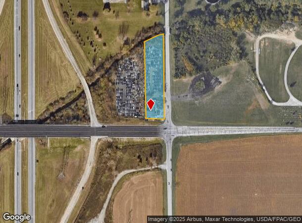
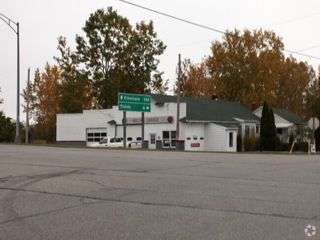
Property Record
4002 Walbridge Rd, Walbridge, OH 43465

NEARBY LISTINGS FOR SALE OR LEASE
Property Detail
4002 Walbridge Rd
H28-712-040401011000
E138 LYING S OF CK SE SE LESS S75 FOR ROAD R/WAY
Autorepair
Wood
AE
Ohio
39173C0053D
1.55 AC
2023
Perrysburg/Northwood
2024
Toledo
020901
Toledo, OH
5,228 SF
DEMOGRAPHICS near 4002 Walbridge Rd
1 mile
3 mile
5 mile
2024 Total Population
1,758
16,297
67,291
2029 Population
1,782
16,354
67,315
Pop Growth 2024-2029
+ 1.37%
+ 0.35%
+ 0.04%
Average Age
46
43
40
2024 Total Households
857
6,967
27,727
HH Growth 2024-2029
+ 1.52%
+ 0.39%
(0.04%)
Median Household Inc
$47,549
$58,094
$50,494
Avg Household Size
2.00
2.30
2.30
2024 Avg HH Vehicles
2.00
2.00
2.00
Median Home Value
$131,666
$162,032
$133,626
Median Year Built
1969
1973
1963
Nearby Places
Map Layers
Map Styles
 Street
 Aerial
Transit
 Traffic
 Biking
Places
Listings with unknown addresses are not visible on the map
- Restaurants
- Banks
- Shops
- Fitness
- Groceries
PUBLIC TRANSPORTATION
COMMUTER RAIL
Toledo (Capitol Limited - Amtrak, Lake Shore Limited - Amtrak)
Drive
Walk
Distance
Toledo (Capitol Limited - Amtrak, Lake Shore Limited - Amtrak)
11 min
7.1 mi
AIRPORT
Eugene F Kranz Toledo Express
Drive
Walk
Distance
Eugene F Kranz Toledo Express
41 min
23.8 mi
Freight Ports
Port of Toledo
Drive
Walk
Distance
Port of Toledo
16 min
7.9 mi
Nearby Properties
Address
Land Use
TOTAL SIZE
Lot Size
Zoning
Address
Land Use
TOTAL SIZE
Lot Size
Zoning
313,004 SF
44.54 AC
40-C2
Address
Land Use
TOTAL SIZE
Lot Size
Zoning
226,469 SF
17.38 AC
Address
Land Use
TOTAL SIZE
Lot Size
Zoning
176,125 SF
21.61 AC
Address
Land Use
TOTAL SIZE
Lot Size
Zoning
136,090 SF
4 AC
Address
Land Use
TOTAL SIZE
Lot Size
Zoning
73,802 SF
22.50 AC
40-R1
Address
Land Use
TOTAL SIZE
Lot Size
Zoning
349,799 SF
51.86 AC
Address
Land Use
TOTAL SIZE
Lot Size
Zoning
102,535 SF
20 AC
40-R2
Address
Land Use
TOTAL SIZE
Lot Size
Zoning
228,251 SF
43.08 AC
10-RD6
Address
Land Use
TOTAL SIZE
Lot Size
Zoning
34 AC
40-C5
Address
Land Use
TOTAL SIZE
Lot Size
Zoning
181,347 SF
14.12 AC
40-R4
Address
Land Use
TOTAL SIZE
Lot Size
Zoning
331,416 SF
30.56 AC
Address
Land Use
TOTAL SIZE
Lot Size
Zoning
199,768 SF
16.15 AC
40-C2
Address
Land Use
TOTAL SIZE
Lot Size
Zoning
40,214 SF
43.55 AC
Address
Land Use
TOTAL SIZE
Lot Size
Zoning
229,500 SF
9.97 AC
Address
Land Use
TOTAL SIZE
Lot Size
Zoning
180,900 SF
5 AC
Address
Land Use
TOTAL SIZE
Lot Size
Zoning
106,525 SF
18.90 AC
Address
Land Use
TOTAL SIZE
Lot Size
Zoning
44.33 AC
40-C2
Address
Land Use
TOTAL SIZE
Lot Size
Zoning
74,842 SF
11.24 AC
Address
Land Use
TOTAL SIZE
Lot Size
Zoning
77,884 SF
6.22 AC
40-R3
Address
Land Use
TOTAL SIZE
Lot Size
Zoning
68,292 SF
10.18 AC
Address
Land Use
TOTAL SIZE
Lot Size
Zoning
9.85 AC
Address
Land Use
TOTAL SIZE
Lot Size
Zoning
118,460 SF
7.75 AC
40-R4
Address
Land Use
TOTAL SIZE
Lot Size
Zoning
10.04 AC
Address
Land Use
TOTAL SIZE
Lot Size
Zoning
90,544 SF
15.04 AC
Address
Land Use
TOTAL SIZE
Lot Size
Zoning
219,362 SF
7.87 AC
Address
Land Use
TOTAL SIZE
Lot Size
Zoning
95,304 SF
5.92 AC
Address
Land Use
TOTAL SIZE
Lot Size
Zoning
35.49 AC
Address
Land Use
TOTAL SIZE
Lot Size
Zoning
36,788 SF
15.05 AC
Address
Land Use
TOTAL SIZE
Lot Size
Zoning
27,910 SF
29.34 AC
Address
Land Use
TOTAL SIZE
Lot Size
Zoning
66,547 SF
6.80 AC
The World's #1 Commercial Real Estate Marketplace
Connect with us
© 2026 CoStar Group
The information above has been obtained from sources believed reliable. While we do not doubt its accuracy we have not verified it and make no guarantee, warranty or representation about it. It is your responsibility to independently confirm its accuracy and completeness. Any projections, opinions, assumptions, or estimates used are for example only and do not represent the current or future performance of the property. The value of this transaction to you depends on tax and other factors which should be evaluated by your tax, financial, and legal advisors. You and your advisors should conduct a careful, independent investigation of the property to determine to your satisfaction the suitability of the property for your needs.