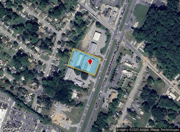
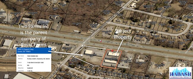
Property Record
4004 S Dupont Hwy, Dover, DE 19901
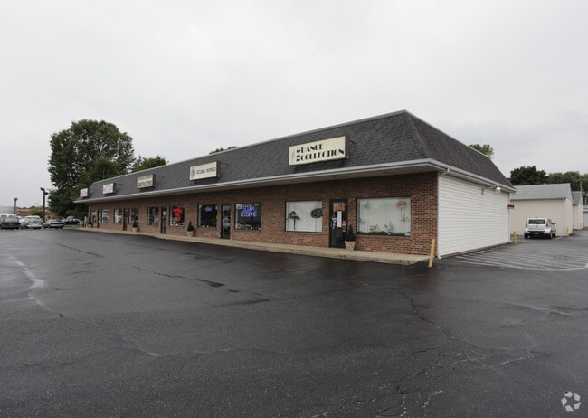
This Property Is For Sale
NEARBY LISTINGS FOR SALE OR LEASE
Property Detail
4004 S Dupont Hwy
7-00-09415-04-0202-000
W. SD. RT. #13 BET. CAMDEN VOSHELL MILL RD., WOODSIDE, 1.26 A
Commercialnec
Kent
X
Delaware
10001C0231H
1.30 AC
2025
Kent County
2025
Philadelphia
041701
Dover, DE
5,600 SF
DEMOGRAPHICS near 4004 S Dupont Hwy
1 Mile
3 Mile
5 Mile
2024 Total Population
6,427
30,425
81,123
2029 Population
6,940
32,638
86,895
Pop Growth 2024-2029
+ 7.98%
+ 7.27%
+ 7.12%
Average Age
40
41
39
2024 Total Households
2,368
11,363
30,868
HH Growth 2024-2029
+ 8.19%
+ 7.52%
+ 7.38%
Median Household Inc
$68,127
$69,066
$64,788
Avg Household Size
2.70
2.60
2.50
2024 Avg HH Vehicles
2.00
2.00
2.00
Median Home Value
$305,523
$278,431
$279,713
Median Year Built
2001
1988
1990
Nearby Places
Map Layers
Map Styles
 Street
 Aerial
- Restaurants
- Banks
- Shops
- Fitness
- Groceries
Nearby Properties
Address
Land Use
TOTAL SIZE
Lot Size
Zoning
Address
Land Use
TOTAL SIZE
Lot Size
Zoning
494,672 SF
35.80 AC
NA
Address
Land Use
TOTAL SIZE
Lot Size
Zoning
309,792 SF
108.80 AC
AC
Address
Land Use
TOTAL SIZE
Lot Size
Zoning
135,552 SF
39.05 AC
AC
Address
Land Use
TOTAL SIZE
Lot Size
Zoning
228,076 SF
15.50 AC
BG
Address
Land Use
TOTAL SIZE
Lot Size
Zoning
108,450 SF
11 AC
RM
Address
Land Use
TOTAL SIZE
Lot Size
Zoning
109,262 SF
15.03 AC
NA
Address
Land Use
TOTAL SIZE
Lot Size
Zoning
5,529 SF
83.30 AC
NA
Address
Land Use
TOTAL SIZE
Lot Size
Zoning
190,988 SF
19.90 AC
NA
Address
Land Use
TOTAL SIZE
Lot Size
Zoning
62,728 SF
25 AC
AC
Address
Land Use
TOTAL SIZE
Lot Size
Zoning
62,572 SF
53 AC
RS1
Address
Land Use
TOTAL SIZE
Lot Size
Zoning
Address
Land Use
TOTAL SIZE
Lot Size
Zoning
91,738 SF
22.17 AC
R1
Address
Land Use
TOTAL SIZE
Lot Size
Zoning
125,394 SF
19.10 AC
RS1
Address
Land Use
TOTAL SIZE
Lot Size
Zoning
70,500 SF
7 AC
RM2
Address
Land Use
TOTAL SIZE
Lot Size
Zoning
34,020 SF
20.46 AC
BN
Address
Land Use
TOTAL SIZE
Lot Size
Zoning
50,428 SF
19.30 AC
BG
Address
Land Use
TOTAL SIZE
Lot Size
Zoning
58,026 SF
17 AC
NA
Address
Land Use
TOTAL SIZE
Lot Size
Zoning
41,588 SF
19.64 AC
AP/10
Address
Land Use
TOTAL SIZE
Lot Size
Zoning
33,120 SF
7.90 AC
IG
Address
Land Use
TOTAL SIZE
Lot Size
Zoning
58,578 SF
3.30 AC
BG
Address
Land Use
TOTAL SIZE
Lot Size
Zoning
60,878 SF
6.80 AC
BG
Address
Land Use
TOTAL SIZE
Lot Size
Zoning
54,621 SF
20 AC
IO
Address
Land Use
TOTAL SIZE
Lot Size
Zoning
43,953 SF
7.40 AC
C4
Address
Land Use
TOTAL SIZE
Lot Size
Zoning
33,674 SF
20 AC
AC
Address
Land Use
TOTAL SIZE
Lot Size
Zoning
23,924 SF
17.70 AC
RS1
Address
Land Use
TOTAL SIZE
Lot Size
Zoning
39,141 SF
4 AC
BG
Address
Land Use
TOTAL SIZE
Lot Size
Zoning
42,765 SF
9.10 AC
NA
Address
Land Use
TOTAL SIZE
Lot Size
Zoning
3,021 SF
106.80 AC
IPM
Address
Land Use
TOTAL SIZE
Lot Size
Zoning
19,905 SF
4.20 AC
RS1
Address
Land Use
TOTAL SIZE
Lot Size
Zoning
9,384 SF
40.17 AC
AC
The World's #1 Commercial Real Estate Marketplace
Connect with us
© 2026 CoStar Group
The information above has been obtained from sources believed reliable. While we do not doubt its accuracy we have not verified it and make no guarantee, warranty or representation about it. It is your responsibility to independently confirm its accuracy and completeness. Any projections, opinions, assumptions, or estimates used are for example only and do not represent the current or future performance of the property. The value of this transaction to you depends on tax and other factors which should be evaluated by your tax, financial, and legal advisors. You and your advisors should conduct a careful, independent investigation of the property to determine to your satisfaction the suitability of the property for your needs.