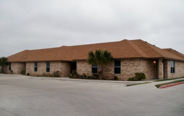
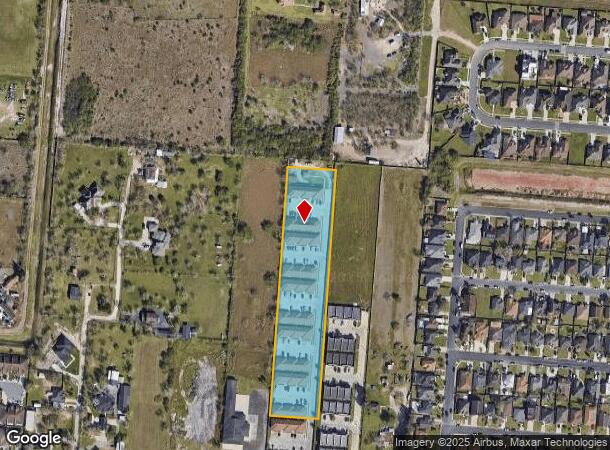
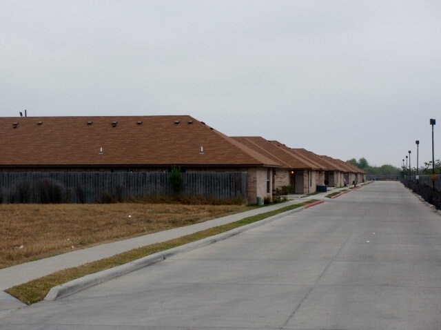
Property Record
4005 Jaime J Zapata Ave, Brownsville, TX 78521
NEARBY LISTINGS FOR SALE OR LEASE
-
-
View all Brownsville listings for sale on LoopNet.com
Property Detail
4005 Jaime J Zapata Ave
Brownsville-Harlingen, TX
El Jardin Subdivision Share 19
747950-0270-012000
EL JARDIN SUBDIVISION SHARE 19 9 BLK 27 TR 2, 3.4820 ACRES
Multifamilydwelling
Cameron
X
Texas
48061C0580F
120
2024
3.48 AC
2025
Greater Brownsville
012608
Brownsville/Harlingen
48,696 SF
DEMOGRAPHICS near 4005 Jaime J Zapata Ave
1 Mile
3 Mile
5 Mile
2024 Total Population
13,105
102,091
188,071
2029 Population
13,564
104,493
192,810
Pop Growth 2024-2029
+ 3.50%
+ 2.35%
+ 2.52%
Average Age
35
35
35
2024 Total Households
4,226
32,239
57,991
HH Growth 2024-2029
+ 3.53%
+ 2.41%
+ 2.53%
Median Household Inc
$64,024
$42,640
$45,096
Avg Household Size
3.00
3.10
3.20
2024 Avg HH Vehicles
2.00
2.00
2.00
Median Home Value
$144,799
$97,716
$95,655
Median Year Built
1999
1991
1992
Nearby Places
Map Layers
Map Styles
 Street
 Aerial
- Restaurants
- Banks
- Shops
- Fitness
- Groceries
PUBLIC TRANSPORTATION
AIRPORT
Brownsville/South Padre Island International
DRIVE
WALK
Distance
Brownsville/South Padre Island International
11 min
4.8 mi
Valley International
DRIVE
WALK
Distance
Valley International
41 min
28.0 mi
Freight Ports
Port of Brownsville
DRIVE
WALK
Distance
Port of Brownsville
8 min
3.7 mi
Nearby Properties
Address
Land Use
TOTAL SIZE
Lot Size
Zoning
Address
Land Use
TOTAL SIZE
Lot Size
Zoning
319,798 SF
46.28 AC
Address
Land Use
TOTAL SIZE
Lot Size
Zoning
452,559 SF
13.79 AC
C
Address
Land Use
TOTAL SIZE
Lot Size
Zoning
135,686 SF
19.05 AC
C
Address
Land Use
TOTAL SIZE
Lot Size
Zoning
286,243 SF
19.21 AC
C
Address
Land Use
TOTAL SIZE
Lot Size
Zoning
72,436 SF
22.08 AC
Address
Land Use
TOTAL SIZE
Lot Size
Zoning
145,240 SF
17.49 AC
Address
Land Use
TOTAL SIZE
Lot Size
Zoning
100,491 SF
14 AC
C
Address
Land Use
TOTAL SIZE
Lot Size
Zoning
132,197 SF
10.70 AC
Address
Land Use
TOTAL SIZE
Lot Size
Zoning
148,781 SF
10.28 AC
B
Address
Land Use
TOTAL SIZE
Lot Size
Zoning
213,521 SF
38.75 AC
Address
Land Use
TOTAL SIZE
Lot Size
Zoning
4.56 AC
C
Address
Land Use
TOTAL SIZE
Lot Size
Zoning
188,446 SF
18.42 AC
Address
Land Use
TOTAL SIZE
Lot Size
Zoning
62,344 SF
2.92 AC
Address
Land Use
TOTAL SIZE
Lot Size
Zoning
115,463 SF
22.09 AC
Address
Land Use
TOTAL SIZE
Lot Size
Zoning
107,815 SF
10 AC
Address
Land Use
TOTAL SIZE
Lot Size
Zoning
142,385 SF
0.50 AC
Address
Land Use
TOTAL SIZE
Lot Size
Zoning
120,166 SF
12.33 AC
Address
Land Use
TOTAL SIZE
Lot Size
Zoning
102,042 SF
8.68 AC
C
Address
Land Use
TOTAL SIZE
Lot Size
Zoning
176,990 SF
18.31 AC
C
Address
Land Use
TOTAL SIZE
Lot Size
Zoning
110,431 SF
15 AC
Address
Land Use
TOTAL SIZE
Lot Size
Zoning
87,909 SF
12 AC
Address
Land Use
TOTAL SIZE
Lot Size
Zoning
112,263 SF
9.66 AC
Address
Land Use
TOTAL SIZE
Lot Size
Zoning
80,480 SF
10.68 AC
Address
Land Use
TOTAL SIZE
Lot Size
Zoning
392,622 SF
55 AC
I
Address
Land Use
TOTAL SIZE
Lot Size
Zoning
86,682 SF
25.76 AC
C
Address
Land Use
TOTAL SIZE
Lot Size
Zoning
241,619 SF
14.68 AC
Address
Land Use
TOTAL SIZE
Lot Size
Zoning
174,826 SF
5.82 AC
Address
Land Use
TOTAL SIZE
Lot Size
Zoning
46,381 SF
2.16 AC
Address
Land Use
TOTAL SIZE
Lot Size
Zoning
48,862 SF
1.22 AC
C
The World's #1 Commercial Real Estate Marketplace
Connect with us
© 2025 CoStar Group
The information above has been obtained from sources believed reliable. While we do not doubt its accuracy we have not verified it and make no guarantee, warranty or representation about it. It is your responsibility to independently confirm its accuracy and completeness. Any projections, opinions, assumptions, or estimates used are for example only and do not represent the current or future performance of the property. The value of this transaction to you depends on tax and other factors which should be evaluated by your tax, financial, and legal advisors. You and your advisors should conduct a careful, independent investigation of the property to determine to your satisfaction the suitability of the property for your needs.