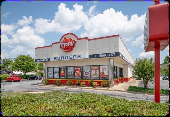
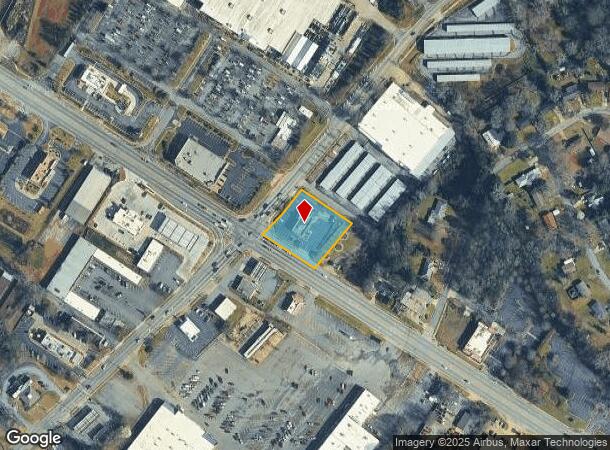
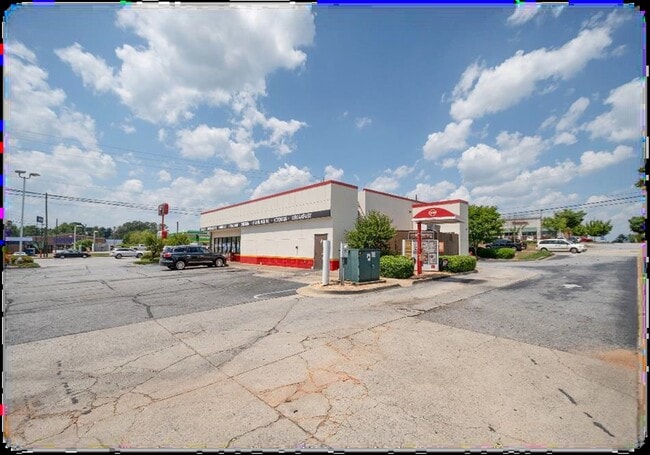
Property Record
4005 Lexington Rd, Athens, GA 30605
NEARBY LISTINGS FOR SALE OR LEASE
Property Detail
4005 Lexington Rd
233B4-C-008
Com-Sf-038
Restaurantdrivein
Clarke
X
Georgia
13059C0027E
0.80 AC
2025
Eastside Athens
2025
Other Market Areas
140600
Athens-Clarke County, GA
2,626 SF
DEMOGRAPHICS near 4005 Lexington Rd
1 Mile
3 Mile
5 Mile
2024 Total Population
6,228
38,550
86,428
2029 Population
6,217
38,540
86,738
Pop Growth 2024-2029
(0.18%)
(0.03%)
+ 0.36%
Average Age
35
35
33
2024 Total Households
2,743
15,680
33,772
HH Growth 2024-2029
(0.15%)
(0.03%)
+ 0.33%
Median Household Inc
$47,111
$49,662
$48,273
Avg Household Size
2.20
2.20
2.20
2024 Avg HH Vehicles
2.00
2.00
2.00
Median Home Value
$198,109
$198,712
$245,815
Median Year Built
1982
1987
1985
Nearby Places
Map Layers
Map Styles
 Street
 Aerial
- Restaurants
- Banks
- Shops
- Fitness
- Groceries
SALE & LEASE HISTORY
LISTING DATE
SALE/LEASE

Jul 16, 2021
For Sale
Nearby Properties
Address
Land Use
TOTAL SIZE
Lot Size
Zoning
Address
Land Use
TOTAL SIZE
Lot Size
Zoning
35 AC
G
Address
Land Use
TOTAL SIZE
Lot Size
Zoning
17.90 AC
G
Address
Land Use
TOTAL SIZE
Lot Size
Zoning
47.56 AC
G
Address
Land Use
TOTAL SIZE
Lot Size
Zoning
2,094.97 AC
G
Address
Land Use
TOTAL SIZE
Lot Size
Zoning
300,000 SF
122.56 AC
G
Address
Land Use
TOTAL SIZE
Lot Size
Zoning
104,964 SF
40.38 AC
RM-2
Address
Land Use
TOTAL SIZE
Lot Size
Zoning
225,000 SF
98.91 AC
G
Address
Land Use
TOTAL SIZE
Lot Size
Zoning
56.20 AC
G
Address
Land Use
TOTAL SIZE
Lot Size
Zoning
21.04 AC
G
Address
Land Use
TOTAL SIZE
Lot Size
Zoning
5.49 AC
G
Address
Land Use
TOTAL SIZE
Lot Size
Zoning
36.88 AC
G
Address
Land Use
TOTAL SIZE
Lot Size
Zoning
986 SF
40.54 AC
RM-1
Address
Land Use
TOTAL SIZE
Lot Size
Zoning
15.29 AC
G
Address
Land Use
TOTAL SIZE
Lot Size
Zoning
4,014 SF
19.22 AC
RM-2
Address
Land Use
TOTAL SIZE
Lot Size
Zoning
26.76 AC
G
Address
Land Use
TOTAL SIZE
Lot Size
Zoning
6,288 SF
14.45 AC
CG
Address
Land Use
TOTAL SIZE
Lot Size
Zoning
2,062 SF
24.33 AC
RM-1
Address
Land Use
TOTAL SIZE
Lot Size
Zoning
28.91 AC
G
Address
Land Use
TOTAL SIZE
Lot Size
Zoning
3,339 SF
16.80 AC
RM-1
Address
Land Use
TOTAL SIZE
Lot Size
Zoning
6.01 AC
G
Address
Land Use
TOTAL SIZE
Lot Size
Zoning
1,624 SF
20.04 AC
RM-1
Address
Land Use
TOTAL SIZE
Lot Size
Zoning
22,920 SF
10.51 AC
C-D
Address
Land Use
TOTAL SIZE
Lot Size
Zoning
74,775 SF
17.95 AC
C-G
Address
Land Use
TOTAL SIZE
Lot Size
Zoning
143,200 SF
19.44 AC
RM-1
Address
Land Use
TOTAL SIZE
Lot Size
Zoning
124,959 SF
20.54 AC
E-I
Address
Land Use
TOTAL SIZE
Lot Size
Zoning
16.58 AC
G
Address
Land Use
TOTAL SIZE
Lot Size
Zoning
76.55 AC
RM-1
Address
Land Use
TOTAL SIZE
Lot Size
Zoning
269,063 SF
1.70 AC
C-D
Address
Land Use
TOTAL SIZE
Lot Size
Zoning
3,617 SF
22 AC
RM-1
Address
Land Use
TOTAL SIZE
Lot Size
Zoning
153.94 AC
G
The World's #1 Commercial Real Estate Marketplace
Connect with us
© 2026 CoStar Group
The information above has been obtained from sources believed reliable. While we do not doubt its accuracy we have not verified it and make no guarantee, warranty or representation about it. It is your responsibility to independently confirm its accuracy and completeness. Any projections, opinions, assumptions, or estimates used are for example only and do not represent the current or future performance of the property. The value of this transaction to you depends on tax and other factors which should be evaluated by your tax, financial, and legal advisors. You and your advisors should conduct a careful, independent investigation of the property to determine to your satisfaction the suitability of the property for your needs.