Property Record
4006 Airport Rd, Plant City, FL 33563

This Property Is For Sale
NEARBY LISTINGS FOR SALE OR LEASE
Property Detail
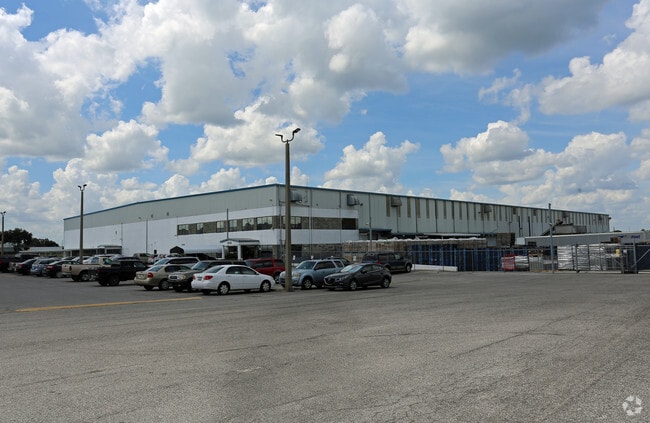
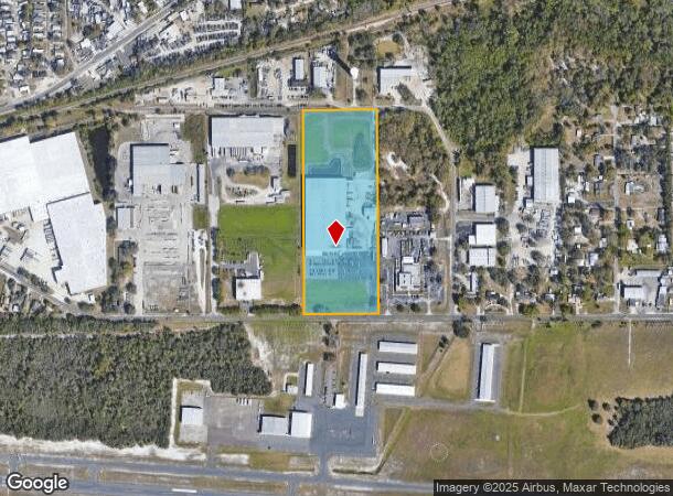
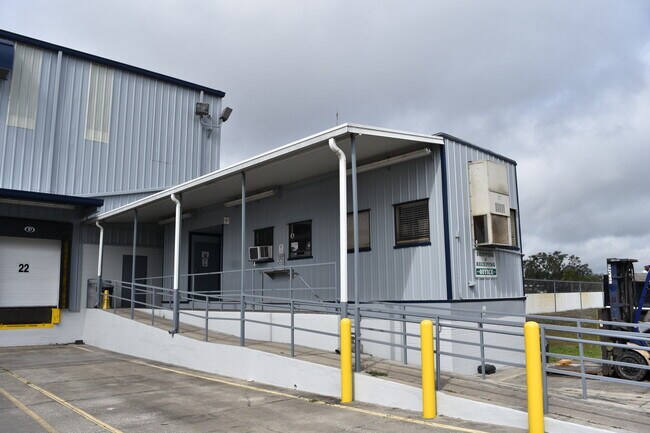
4006 Airport Rd
Tampa-St. Petersburg-Clearwater, FL
Unplatted
P-36-28-21-ZZZ-000005-97780.0
THAT PART OF SW 1/4 OF NE 1/4 AND SE 1/4 OF NW 1/4 DESC AS BEG 30 FT N AND 1160 FT W OF SE COR OF SW 1/4 OF NE 1/4 RUN W 467.63 FT N 1255.43 FT E TO A POINT N OF POB AND S TO POB
Warehouse
Hillsborough
X
Florida
12057C0268H
97780
2024
13.64 AC
2024
E Hillsborough/Plant
012501
Tampa/St Petersburg
162,472 SF
DEMOGRAPHICS near 4006 Airport Rd
1 Mile
3 Mile
5 Mile
2024 Total Population
5,708
41,184
75,188
2029 Population
6,196
44,791
82,044
Pop Growth 2024-2029
+ 8.55%
+ 8.76%
+ 9.12%
Average Age
36
38
39
2024 Total Households
1,812
14,187
25,648
HH Growth 2024-2029
+ 8.83%
+ 9.02%
+ 9.39%
Median Household Inc
$65,971
$59,472
$58,658
Avg Household Size
3.10
2.80
2.80
2024 Avg HH Vehicles
2.00
2.00
2.00
Median Home Value
$190,522
$251,408
$252,373
Median Year Built
1988
1986
1987
Nearby Places
- Restaurants
- Banks
- Shops
- Fitness
- Groceries
PUBLIC TRANSPORTATION
AIRPORT
Tampa International
DRIVE
WALK
Distance
Tampa International
41 min
28.9 mi
Freight Ports
Port of Tampa Bay
DRIVE
WALK
Distance
Port of Tampa Bay
34 min
22.4 mi
Nearby Properties
Address
Land Use
TOTAL SIZE
Lot Size
Zoning
Address
Land Use
TOTAL SIZE
Lot Size
Zoning
286,824 SF
43.15 AC
PD
Address
Land Use
TOTAL SIZE
Lot Size
Zoning
235,102 SF
7.73 AC
P
Address
Land Use
TOTAL SIZE
Lot Size
Zoning
400,224 SF
39.13 AC
I
Address
Land Use
TOTAL SIZE
Lot Size
Zoning
296,496 SF
77.52 AC
P
Address
Land Use
TOTAL SIZE
Lot Size
Zoning
496,217 SF
35.02 AC
I
Address
Land Use
TOTAL SIZE
Lot Size
Zoning
93,924 SF
3.96 AC
DC
Address
Land Use
TOTAL SIZE
Lot Size
Zoning
35,426 SF
39.92 AC
P
Address
Land Use
TOTAL SIZE
Lot Size
Zoning
192,911 SF
16.36 AC
PD
Address
Land Use
TOTAL SIZE
Lot Size
Zoning
177,038 SF
16.95 AC
PD
Address
Land Use
TOTAL SIZE
Lot Size
Zoning
202,712 SF
28.41 AC
C
Address
Land Use
TOTAL SIZE
Lot Size
Zoning
154,237 SF
17.92 AC
C
Address
Land Use
TOTAL SIZE
Lot Size
Zoning
122,234 SF
191.15 AC
I
Address
Land Use
TOTAL SIZE
Lot Size
Zoning
159,805 SF
78.29 AC
P
Address
Land Use
TOTAL SIZE
Lot Size
Zoning
127,470 SF
7.84 AC
R-20
Address
Land Use
TOTAL SIZE
Lot Size
Zoning
73,613 SF
57.94 AC
R-1A
Address
Land Use
TOTAL SIZE
Lot Size
Zoning
145,521 SF
19.83 AC
C
Address
Land Use
TOTAL SIZE
Lot Size
Zoning
125,744 SF
19.48 AC
I
Address
Land Use
TOTAL SIZE
Lot Size
Zoning
242,449 SF
19.97 AC
R-6
Address
Land Use
TOTAL SIZE
Lot Size
Zoning
109,293 SF
18.01 AC
R-12
Address
Land Use
TOTAL SIZE
Lot Size
Zoning
481,620 SF
23.85 AC
I
Address
Land Use
TOTAL SIZE
Lot Size
Zoning
114,055 SF
12.23 AC
R-6
Address
Land Use
TOTAL SIZE
Lot Size
Zoning
66,199 SF
4.32 AC
P
Address
Land Use
TOTAL SIZE
Lot Size
Zoning
90,436 SF
6.11 AC
C-1
Address
Land Use
TOTAL SIZE
Lot Size
Zoning
40,530 SF
2.36 AC
DC
Address
Land Use
TOTAL SIZE
Lot Size
Zoning
222,527 SF
17.75 AC
C-1
Address
Land Use
TOTAL SIZE
Lot Size
Zoning
90,504 SF
5.33 AC
I
Address
Land Use
TOTAL SIZE
Lot Size
Zoning
149,952 SF
19.41 AC
I
Address
Land Use
TOTAL SIZE
Lot Size
Zoning
59,031 SF
29.87 AC
R-6
Address
Land Use
TOTAL SIZE
Lot Size
Zoning
73,380 SF
8.32 AC
PD
Address
Land Use
TOTAL SIZE
Lot Size
Zoning
84,788 SF
1.74 AC
DC
The World's #1 Commercial Real Estate Marketplace
Connect with us
© 2025 CoStar Group
The information above has been obtained from sources believed reliable. While we do not doubt its accuracy we have not verified it and make no guarantee, warranty or representation about it. It is your responsibility to independently confirm its accuracy and completeness. Any projections, opinions, assumptions, or estimates used are for example only and do not represent the current or future performance of the property. The value of this transaction to you depends on tax and other factors which should be evaluated by your tax, financial, and legal advisors. You and your advisors should conduct a careful, independent investigation of the property to determine to your satisfaction the suitability of the property for your needs.