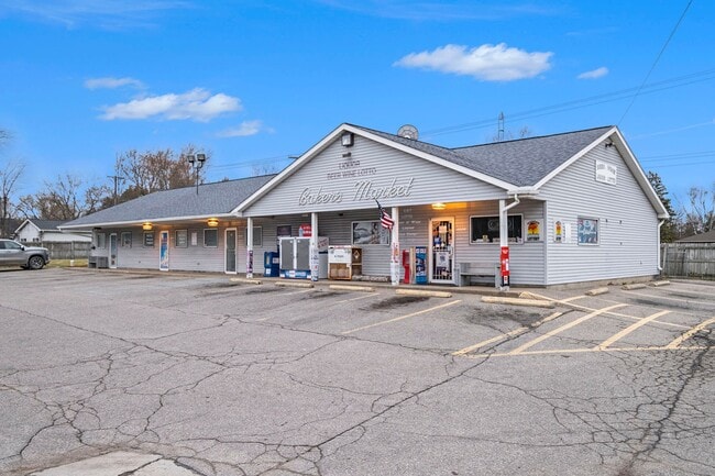
Property Record
4006 N Irish Rd, Davison, MI 48423

NEARBY LISTINGS FOR SALE OR LEASE
Property Detail
4006 N Irish Rd
Flint, MI
Dickinson Acres Sub
16-29-551-027
S 44.06 FT OF W 132 FT OF LOT 12 DICKENSON ACRES & A PARCEL OF LAND BEG AT SW COR OF SEC TH N 0 DEG 52 MIN E 199.60 FT TH E
Commercialnec
Genesee
X
Michigan
26049C0210D
12
2024
0.89 AC
2025
Flint
011800
Detroit
3,700 SF
DEMOGRAPHICS near 4006 N Irish Rd
1 Mile
3 Mile
5 Mile
2024 Total Population
685
18,863
57,015
2029 Population
663
18,381
55,711
Pop Growth 2024-2029
(3.21%)
(2.56%)
(2.29%)
Average Age
44
41
41
2024 Total Households
279
7,803
23,989
HH Growth 2024-2029
(3.23%)
(2.58%)
(2.33%)
Median Household Inc
$74,711
$64,270
$56,974
Avg Household Size
2.50
2.40
2.30
2024 Avg HH Vehicles
2.00
2.00
2.00
Median Home Value
$212,143
$166,749
$156,742
Median Year Built
1991
1973
1971
Nearby Places
Map Layers
Map Styles
 Street
 Aerial
- Restaurants
- Banks
- Shops
- Fitness
- Groceries
PUBLIC TRANSPORTATION
AIRPORT
Bishop International
DRIVE
WALK
Distance
Bishop International
34 min
18.0 mi
SALE & LEASE HISTORY
LISTING DATE
SALE/LEASE

Nov 07, 2016
For Lease
Mar 13, 2024
For Sale
Nearby Properties
Address
Land Use
TOTAL SIZE
Lot Size
Zoning
Address
Land Use
TOTAL SIZE
Lot Size
Zoning
51.59 AC
NOT AVAILA
Address
Land Use
TOTAL SIZE
Lot Size
Zoning
34,652 SF
208.43 AC
SRA
Address
Land Use
TOTAL SIZE
Lot Size
Zoning
302,862 SF
27.14 AC
NOT AVAILA
Address
Land Use
TOTAL SIZE
Lot Size
Zoning
156,996 SF
NOT AVAILA
Address
Land Use
TOTAL SIZE
Lot Size
Zoning
Address
Land Use
TOTAL SIZE
Lot Size
Zoning
6,449 SF
90.81 AC
MH
Address
Land Use
TOTAL SIZE
Lot Size
Zoning
44,280 SF
5.48 AC
C-3
Address
Land Use
TOTAL SIZE
Lot Size
Zoning
79,677 SF
13.79 AC
B-1
Address
Land Use
TOTAL SIZE
Lot Size
Zoning
101,648 SF
18.65 AC
I
Address
Land Use
TOTAL SIZE
Lot Size
Zoning
59,420 SF
5.25 AC
C-3
Address
Land Use
TOTAL SIZE
Lot Size
Zoning
49,688 SF
8.79 AC
NOT AVAILA
Address
Land Use
TOTAL SIZE
Lot Size
Zoning
10,806 SF
6.52 AC
NOT AVAILA
Address
Land Use
TOTAL SIZE
Lot Size
Zoning
10.05 AC
NOT AVAILA
Address
Land Use
TOTAL SIZE
Lot Size
Zoning
58,197 SF
11.90 AC
C-2
Address
Land Use
TOTAL SIZE
Lot Size
Zoning
28.20 AC
Address
Land Use
TOTAL SIZE
Lot Size
Zoning
34,496 SF
2.95 AC
C-3
Address
Land Use
TOTAL SIZE
Lot Size
Zoning
1,850 SF
32.92 AC
B-2
Address
Land Use
TOTAL SIZE
Lot Size
Zoning
36,620 SF
47.81 AC
CB
Address
Land Use
TOTAL SIZE
Lot Size
Zoning
8.37 AC
CB
Address
Land Use
TOTAL SIZE
Lot Size
Zoning
12,704 SF
1.80 AC
NOT AVAILA
Address
Land Use
TOTAL SIZE
Lot Size
Zoning
2,008 SF
C-3
Address
Land Use
TOTAL SIZE
Lot Size
Zoning
11,070 SF
1.16 AC
C-3
Address
Land Use
TOTAL SIZE
Lot Size
Zoning
16,525 SF
30.59 AC
NOT AVAILA
Address
Land Use
TOTAL SIZE
Lot Size
Zoning
67,303 SF
3.49 AC
I
Address
Land Use
TOTAL SIZE
Lot Size
Zoning
40,393 SF
10.05 AC
I
Address
Land Use
TOTAL SIZE
Lot Size
Zoning
11,555 SF
4.91 AC
NOT AVAILA
Address
Land Use
TOTAL SIZE
Lot Size
Zoning
3,746 SF
0.85 AC
C-3
Address
Land Use
TOTAL SIZE
Lot Size
Zoning
44,160 SF
4.47 AC
C-2 HWY CO
Address
Land Use
TOTAL SIZE
Lot Size
Zoning
Address
Land Use
TOTAL SIZE
Lot Size
Zoning
25,460 SF
2.68 AC
NOT AVAILA
The World's #1 Commercial Real Estate Marketplace
Connect with us
© 2025 CoStar Group
The information above has been obtained from sources believed reliable. While we do not doubt its accuracy we have not verified it and make no guarantee, warranty or representation about it. It is your responsibility to independently confirm its accuracy and completeness. Any projections, opinions, assumptions, or estimates used are for example only and do not represent the current or future performance of the property. The value of this transaction to you depends on tax and other factors which should be evaluated by your tax, financial, and legal advisors. You and your advisors should conduct a careful, independent investigation of the property to determine to your satisfaction the suitability of the property for your needs.