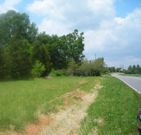
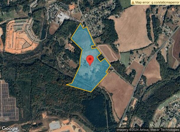
Property Record
4007 C And B Farm Rd, Conover, NC 28613
NEARBY LISTINGS FOR SALE OR LEASE
Property Detail
4007 C And B Farm Rd
3743168248930000
PLAT 81-196
Agriculturalland
Catawba
AE
North Carolina
3710374300J
59.71 AC
2024
Catawba County
2025
Charlotte
010203
Hickory-Lenoir-Morganton, NC
1,008 SF
DEMOGRAPHICS near 4007 C And B Farm Rd
1 Mile
3 Mile
5 Mile
2024 Total Population
1,202
14,629
40,362
2029 Population
1,241
15,255
42,051
Pop Growth 2024-2029
+ 3.24%
+ 4.28%
+ 4.18%
Average Age
40
42
41
2024 Total Households
455
5,819
15,664
HH Growth 2024-2029
+ 3.30%
+ 4.14%
+ 4.10%
Median Household Inc
$61,317
$61,094
$57,501
Avg Household Size
2.60
2.50
2.50
2024 Avg HH Vehicles
2.00
2.00
2.00
Median Home Value
$171,692
$200,753
$183,515
Median Year Built
1993
1991
1987
Nearby Places
Map Layers
Map Styles
 Street
 Aerial
- Restaurants
- Banks
- Shops
- Fitness
- Groceries
Nearby Properties
Address
Land Use
TOTAL SIZE
Lot Size
Zoning
Address
Land Use
TOTAL SIZE
Lot Size
Zoning
7,684 SF
11.85 AC
R-20-CD
Address
Land Use
TOTAL SIZE
Lot Size
Zoning
82,274 SF
19.77 AC
M-1-CD
Address
Land Use
TOTAL SIZE
Lot Size
Zoning
217,586 SF
28.33 AC
CC-CD
Address
Land Use
TOTAL SIZE
Lot Size
Zoning
30.63 AC
R-20
Address
Land Use
TOTAL SIZE
Lot Size
Zoning
4,700 SF
34.87 AC
COI
Address
Land Use
TOTAL SIZE
Lot Size
Zoning
150,498 SF
11.27 AC
M-1
Address
Land Use
TOTAL SIZE
Lot Size
Zoning
23,646 SF
79.60 AC
M-1
Address
Land Use
TOTAL SIZE
Lot Size
Zoning
9,064 SF
4.59 AC
B-2-CD
Address
Land Use
TOTAL SIZE
Lot Size
Zoning
283,942 SF
26.59 AC
M-1
Address
Land Use
TOTAL SIZE
Lot Size
Zoning
155,824 SF
27.77 AC
M-1
Address
Land Use
TOTAL SIZE
Lot Size
Zoning
14,702 SF
363.28 AC
R-20
Address
Land Use
TOTAL SIZE
Lot Size
Zoning
15.14 AC
NC
Address
Land Use
TOTAL SIZE
Lot Size
Zoning
29,958 SF
2.09 AC
CC
Address
Land Use
TOTAL SIZE
Lot Size
Zoning
12,032 SF
12.15 AC
B-2
Address
Land Use
TOTAL SIZE
Lot Size
Zoning
49,109 SF
19.39 AC
B-2
Address
Land Use
TOTAL SIZE
Lot Size
Zoning
21.85 AC
R-20
Address
Land Use
TOTAL SIZE
Lot Size
Zoning
133,559 SF
15.08 AC
B-2-CD
Address
Land Use
TOTAL SIZE
Lot Size
Zoning
13.54 AC
R-20
Address
Land Use
TOTAL SIZE
Lot Size
Zoning
22,000 SF
14.44 AC
B-3
Address
Land Use
TOTAL SIZE
Lot Size
Zoning
117,101 SF
17.05 AC
M-1
Address
Land Use
TOTAL SIZE
Lot Size
Zoning
15,202 SF
352.85 AC
R-20
Address
Land Use
TOTAL SIZE
Lot Size
Zoning
116,145 SF
9.16 AC
EM-1
Address
Land Use
TOTAL SIZE
Lot Size
Zoning
20,818 SF
23.72 AC
M-1
Address
Land Use
TOTAL SIZE
Lot Size
Zoning
37,622 SF
3.76 AC
B-2-CD
Address
Land Use
TOTAL SIZE
Lot Size
Zoning
28,655 SF
4.81 AC
R-9A
Address
Land Use
TOTAL SIZE
Lot Size
Zoning
129,960 SF
19.23 AC
M-1
Address
Land Use
TOTAL SIZE
Lot Size
Zoning
29,632 SF
7.41 AC
R-9A
Address
Land Use
TOTAL SIZE
Lot Size
Zoning
36,259 SF
7 AC
P-1
Address
Land Use
TOTAL SIZE
Lot Size
Zoning
10,125 SF
1.20 AC
B-2
Address
Land Use
TOTAL SIZE
Lot Size
Zoning
33,002 SF
12.43 AC
B-3
The World's #1 Commercial Real Estate Marketplace
Connect with us
© 2026 CoStar Group
The information above has been obtained from sources believed reliable. While we do not doubt its accuracy we have not verified it and make no guarantee, warranty or representation about it. It is your responsibility to independently confirm its accuracy and completeness. Any projections, opinions, assumptions, or estimates used are for example only and do not represent the current or future performance of the property. The value of this transaction to you depends on tax and other factors which should be evaluated by your tax, financial, and legal advisors. You and your advisors should conduct a careful, independent investigation of the property to determine to your satisfaction the suitability of the property for your needs.