Property Record
4009 E Francis Ave, Spokane, WA 99217
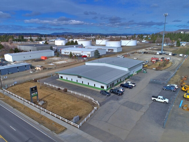


Property Detail
4009 E Francis Ave
36274.1701
27-26-43 LOT 1 ALTERED SP-1561A-12 (AFN# 6696517)
Wholesaleoutletdiscountstore
Spokane
LI
Washington
B and X Area of moderate flood hazard, usually the area between the limits of the 100-year and 500-year floods.
1
2026
4.85 AC
2026
NE North Metro
011202
Spokane
18,890 SF
Spokane-Spokane Valley, WA
NEARBY LISTINGS FOR SALE OR LEASE
DEMOGRAPHICS near 4009 E Francis Ave
1 mile
3 mile
5 mile
2025 Total Population
2,889
63,818
179,741
2030 Population
2,954
64,760
182,472
Pop Growth 2025-2030
+ 2.25%
+ 1.48%
+ 1.52%
Average Age
40
39
39
2025 Total Households
1,117
26,038
70,807
HH Growth 2025-2030
+ 2.15%
+ 1.48%
+ 1.55%
Median Household Inc
$51,602
$57,747
$64,656
Avg Household Size
2.50
2.40
2.40
2025 Avg HH Vehicles
2.00
2.00
2.00
Median Home Value
$314,598
$315,977
$346,759
Median Year Built
1959
1973
1967
Nearby Places
Map Layers
Map Styles
 Street
 Aerial
Layers
 Traffic
 Biking
Places
Listings with unknown addresses are not visible on the map
- Restaurants
- Banks
- Shops
- Fitness
- Groceries
PUBLIC TRANSPORTATION
COMMUTER RAIL
Drive
Walk
Distance
18 min
6.7 mi
AIRPORT
Spokane International
Drive
Walk
Distance
Spokane International
26 min
13.9 mi
SALE & LEASE HISTORY
LISTING DATE
SALE/LEASE

Feb 17, 2020
For Sale
Aug 18, 2021
For Sale
Nearby Properties
Address
Land Use
TOTAL SIZE
Lot Size
Zoning
Address
Land Use
TOTAL SIZE
Lot Size
Zoning
427,054 SF
16.60 AC
LI
Address
Land Use
TOTAL SIZE
Lot Size
Zoning
456,984 SF
26.06 AC
O
Address
Land Use
TOTAL SIZE
Lot Size
Zoning
530,527 SF
17.11 AC
CC2
Address
Land Use
TOTAL SIZE
Lot Size
Zoning
468,006 SF
22.81 AC
RSF
Address
Land Use
TOTAL SIZE
Lot Size
Zoning
306,460 SF
27.56 AC
RMF
Address
Land Use
TOTAL SIZE
Lot Size
Zoning
180,822 SF
16.11 AC
CC1
Address
Land Use
TOTAL SIZE
Lot Size
Zoning
696,382 SF
37.43 AC
LI
Address
Land Use
TOTAL SIZE
Lot Size
Zoning
1,572,216 SF
23.12 AC
GC
Address
Land Use
TOTAL SIZE
Lot Size
Zoning
148,224 SF
4.98 AC
GC
Address
Land Use
TOTAL SIZE
Lot Size
Zoning
125,302 SF
7.79 AC
RMF
Address
Land Use
TOTAL SIZE
Lot Size
Zoning
141,474 SF
6.60 AC
RMF
Address
Land Use
TOTAL SIZE
Lot Size
Zoning
206,111 SF
3.88 AC
RMF
Address
Land Use
TOTAL SIZE
Lot Size
Zoning
136,780 SF
8.75 AC
RMF
Address
Land Use
TOTAL SIZE
Lot Size
Zoning
153,780 SF
10.31 AC
RMF
Address
Land Use
TOTAL SIZE
Lot Size
Zoning
160,810 SF
25.18 AC
RMF
Address
Land Use
TOTAL SIZE
Lot Size
Zoning
131,469 SF
7.24 AC
RMF
Address
Land Use
TOTAL SIZE
Lot Size
Zoning
67,094 SF
9.33 AC
RSF
Address
Land Use
TOTAL SIZE
Lot Size
Zoning
95,030 SF
3.51 AC
CC1
Address
Land Use
TOTAL SIZE
Lot Size
Zoning
125,588 SF
12.84 AC
RMF
Address
Land Use
TOTAL SIZE
Lot Size
Zoning
96,424 SF
9.04 AC
I-1
Address
Land Use
TOTAL SIZE
Lot Size
Zoning
183,704 SF
12.67 AC
RMF
Address
Land Use
TOTAL SIZE
Lot Size
Zoning
180,440 SF
13.94 AC
RMF
Address
Land Use
TOTAL SIZE
Lot Size
Zoning
142,448 SF
14.85 AC
RMF
Address
Land Use
TOTAL SIZE
Lot Size
Zoning
35,343 SF
5.31 AC
GC
Address
Land Use
TOTAL SIZE
Lot Size
Zoning
230,295 SF
22.41 AC
GC
Address
Land Use
TOTAL SIZE
Lot Size
Zoning
100,172 SF
5.48 AC
RMF
Address
Land Use
TOTAL SIZE
Lot Size
Zoning
68,197 SF
5.16 AC
RSF
Address
Land Use
TOTAL SIZE
Lot Size
Zoning
107,539 SF
7.54 AC
RMF
Address
Land Use
TOTAL SIZE
Lot Size
Zoning
115,461 SF
10.89 AC
RMF
Address
Land Use
TOTAL SIZE
Lot Size
Zoning
103,755 SF
7.64 AC
CC2
The World's #1 Commercial Real Estate Marketplace
Connect with us
© 2026 CoStar Group
The information above has been obtained from sources believed reliable. While we do not doubt its accuracy we have not verified it and make no guarantee, warranty or representation about it. It is your responsibility to independently confirm its accuracy and completeness. Any projections, opinions, assumptions, or estimates used are for example only and do not represent the current or future performance of the property. The value of this transaction to you depends on tax and other factors which should be evaluated by your tax, financial, and legal advisors. You and your advisors should conduct a careful, independent investigation of the property to determine to your satisfaction the suitability of the property for your needs.