Property Record
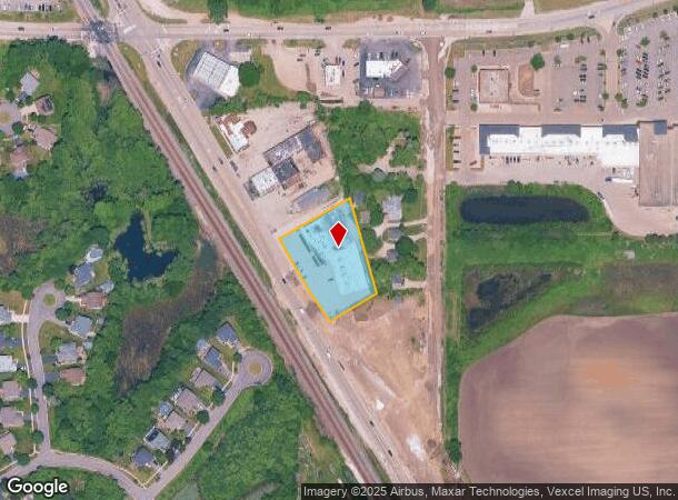
405 S Il Route 83, Grayslake, IL 60030
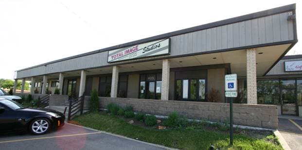
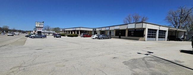

This Property Is For Sale
NEARBY LISTINGS FOR SALE OR LEASE
Property Detail
405 S Il Route 83
06-35-200-036
Pt Sw
Commercialbuilding
PT SW NE & NW SE;BEG ON CLN RTE21 636.2SE OF X CLN BELVIDER E RD,NE242MOL TO PNT 207S OF NW COR DOC 551189,SE258.12TO PNT 160W OF E LN NW SE,SW AT RA TO CLNRT21 178.2,NW ALG S
X
Lake
17097C0134L
Illinois
2023
1.21 AC
2024
Far North
861106
Chicago
17,386 SF
Chicago-Naperville-Elgin, IL-IN-WI
DEMOGRAPHICS near 405 S Il Route 83
1 Mile
3 Mile
5 Mile
2024 Total Population
5,507
43,104
136,676
2029 Population
5,425
42,494
134,567
Pop Growth 2024-2029
(1.49%)
(1.42%)
(1.54%)
Average Age
39
40
40
2024 Total Households
2,150
16,161
48,458
HH Growth 2024-2029
(1.58%)
(1.47%)
(1.64%)
Median Household Inc
$99,193
$95,961
$99,519
Avg Household Size
2.50
2.60
2.80
2024 Avg HH Vehicles
2.00
2.00
2.00
Median Home Value
$270,949
$248,817
$257,339
Median Year Built
1992
1991
1990
Nearby Places
Map Layers
Map Styles
 Street
 Aerial
- Restaurants
- Banks
- Shops
- Fitness
- Groceries
PUBLIC TRANSPORTATION
COMMUTER RAIL
Grayslake Station (MD-N) (Milwaukee District North Line - Northeast Illinois Regional Commuter Railroad (Metra))
DRIVE
WALK
Distance
Grayslake Station (MD-N) (Milwaukee District North Line - Northeast Illinois Regional Commuter Railroad (Metra))
4 min
1.2 mi
Prairie Crossing Station (MD-North) (Milwaukee District North Line - Northeast Illinois Regional Commuter Railroad (Metra))
DRIVE
WALK
Distance
Prairie Crossing Station (MD-North) (Milwaukee District North Line - Northeast Illinois Regional Commuter Railroad (Metra))
3 min
1.7 mi
AIRPORT
Chicago O'Hare International
DRIVE
WALK
Distance
Chicago O'Hare International
67 min
39.3 mi
Freight Ports
Port Milwaukee
DRIVE
WALK
Distance
Port Milwaukee
65 min
52.9 mi
Nearby Properties
Address
Land Use
TOTAL SIZE
Lot Size
Zoning
Address
Land Use
TOTAL SIZE
Lot Size
Zoning
1,401,971 SF
85.78 AC
Address
Land Use
TOTAL SIZE
Lot Size
Zoning
596,712 SF
35.56 AC
Address
Land Use
TOTAL SIZE
Lot Size
Zoning
2,993,760 SF
20.63 AC
Address
Land Use
TOTAL SIZE
Lot Size
Zoning
Address
Land Use
TOTAL SIZE
Lot Size
Zoning
298,181 SF
20.41 AC
Address
Land Use
TOTAL SIZE
Lot Size
Zoning
177,993 SF
10 AC
Address
Land Use
TOTAL SIZE
Lot Size
Zoning
135,180 SF
22.05 AC
Address
Land Use
TOTAL SIZE
Lot Size
Zoning
217,620 SF
13.07 AC
Address
Land Use
TOTAL SIZE
Lot Size
Zoning
192,330 SF
10.23 AC
Address
Land Use
TOTAL SIZE
Lot Size
Zoning
175,833 SF
7.70 AC
Address
Land Use
TOTAL SIZE
Lot Size
Zoning
308,160 SF
7.43 AC
Address
Land Use
TOTAL SIZE
Lot Size
Zoning
282,999 SF
23.06 AC
Address
Land Use
TOTAL SIZE
Lot Size
Zoning
428,703 SF
24.63 AC
Address
Land Use
TOTAL SIZE
Lot Size
Zoning
71,320 SF
26.33 AC
Address
Land Use
TOTAL SIZE
Lot Size
Zoning
Address
Land Use
TOTAL SIZE
Lot Size
Zoning
95,180 SF
12.40 AC
Address
Land Use
TOTAL SIZE
Lot Size
Zoning
100,123 SF
12.63 AC
Address
Land Use
TOTAL SIZE
Lot Size
Zoning
Address
Land Use
TOTAL SIZE
Lot Size
Zoning
89,754 SF
8.64 AC
Address
Land Use
TOTAL SIZE
Lot Size
Zoning
142,290 SF
10.56 AC
Address
Land Use
TOTAL SIZE
Lot Size
Zoning
6.04 AC
Address
Land Use
TOTAL SIZE
Lot Size
Zoning
129,075 SF
8.79 AC
Address
Land Use
TOTAL SIZE
Lot Size
Zoning
132,256 SF
18.59 AC
Address
Land Use
TOTAL SIZE
Lot Size
Zoning
79,136 SF
30.10 AC
Address
Land Use
TOTAL SIZE
Lot Size
Zoning
71,064 SF
29.20 AC
Address
Land Use
TOTAL SIZE
Lot Size
Zoning
92,245 SF
5.89 AC
Address
Land Use
TOTAL SIZE
Lot Size
Zoning
70,256 SF
33.85 AC
Address
Land Use
TOTAL SIZE
Lot Size
Zoning
3.72 AC
Address
Land Use
TOTAL SIZE
Lot Size
Zoning
2.88 AC
Address
Land Use
TOTAL SIZE
Lot Size
Zoning
519,710 SF
16.32 AC
The World's #1 Commercial Real Estate Marketplace
Connect with us
© 2026 CoStar Group
The information above has been obtained from sources believed reliable. While we do not doubt its accuracy we have not verified it and make no guarantee, warranty or representation about it. It is your responsibility to independently confirm its accuracy and completeness. Any projections, opinions, assumptions, or estimates used are for example only and do not represent the current or future performance of the property. The value of this transaction to you depends on tax and other factors which should be evaluated by your tax, financial, and legal advisors. You and your advisors should conduct a careful, independent investigation of the property to determine to your satisfaction the suitability of the property for your needs.