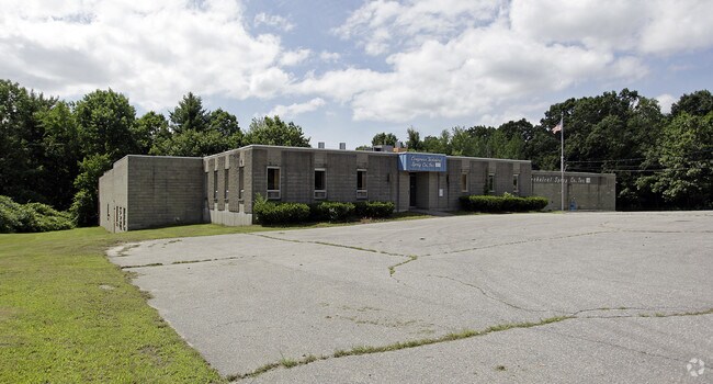
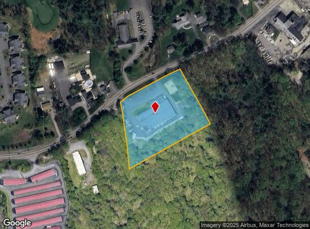
Property Record
401 Broadway Rd, Dracut, MA 01826

NEARBY LISTINGS FOR SALE OR LEASE
Property Detail
401 Broadway Rd
DRAC-000037-000000-000073
Middlesex
Commercialbuilding
Massachusetts
X
73
25009C0195G
3.74 AC
2025
Groton/Townsend
2025
Boston
314301
Boston-Cambridge-Newton, MA-NH
23,208 SF
DEMOGRAPHICS near 401 Broadway Rd
1 Mile
3 Mile
5 Mile
2024 Total Population
3,472
69,701
178,107
2029 Population
3,432
68,752
175,836
Pop Growth 2024-2029
(1.15%)
(1.36%)
(1.28%)
Average Age
42
39
39
2024 Total Households
1,208
25,796
64,049
HH Growth 2024-2029
(1.32%)
(1.40%)
(1.32%)
Median Household Inc
$114,224
$74,040
$81,830
Avg Household Size
2.80
2.50
2.60
2024 Avg HH Vehicles
2.00
2.00
2.00
Median Home Value
$492,161
$404,961
$412,467
Median Year Built
1977
1961
1964
Nearby Places
Map Layers
Map Styles
 Street
 Aerial
- Restaurants
- Banks
- Shops
- Fitness
- Groceries
PUBLIC TRANSPORTATION
COMMUTER RAIL
Lowell (Lowell Line - Massachusetts Bay Transportation Authority Commuter Rail (Purple Line))
DRIVE
WALK
Distance
Lowell (Lowell Line - Massachusetts Bay Transportation Authority Commuter Rail (Purple Line))
9 min
4.1 mi
North Billerica (Lowell Line - Massachusetts Bay Transportation Authority Commuter Rail (Purple Line))
DRIVE
WALK
Distance
North Billerica (Lowell Line - Massachusetts Bay Transportation Authority Commuter Rail (Purple Line))
17 min
7.6 mi
AIRPORT
Manchester Boston Regional
DRIVE
WALK
Distance
Manchester Boston Regional
46 min
29.5 mi
General Edward Lawrence Logan International
DRIVE
WALK
Distance
General Edward Lawrence Logan International
46 min
33.3 mi
Portsmouth International at Pease
DRIVE
WALK
Distance
Portsmouth International at Pease
62 min
45.8 mi
Freight Ports
Port of Boston
DRIVE
WALK
Distance
Port of Boston
47 min
33.0 mi
SALE & LEASE HISTORY
LISTING DATE
SALE/LEASE

Sep 25, 2016
For Lease
Nearby Properties
Address
Land Use
TOTAL SIZE
Lot Size
Zoning
Address
Land Use
TOTAL SIZE
Lot Size
Zoning
70.20 AC
R3
Address
Land Use
TOTAL SIZE
Lot Size
Zoning
30,744 SF
31.28 AC
INST
Address
Land Use
TOTAL SIZE
Lot Size
Zoning
803 SF
3.29 AC
R1
Address
Land Use
TOTAL SIZE
Lot Size
Zoning
215,884 SF
1.55 AC
DMU
Address
Land Use
TOTAL SIZE
Lot Size
Zoning
134,439 SF
3.29 AC
DMU
Address
Land Use
TOTAL SIZE
Lot Size
Zoning
2.15 AC
INST
Address
Land Use
TOTAL SIZE
Lot Size
Zoning
6.27 AC
DMU
Address
Land Use
TOTAL SIZE
Lot Size
Zoning
225,252 SF
2.31 AC
DMU
Address
Land Use
TOTAL SIZE
Lot Size
Zoning
152,040 SF
9.10 AC
SRC
Address
Land Use
TOTAL SIZE
Lot Size
Zoning
10.48 AC
INST
Address
Land Use
TOTAL SIZE
Lot Size
Zoning
2.62 AC
INST
Address
Land Use
TOTAL SIZE
Lot Size
Zoning
7.25 AC
INST
Address
Land Use
TOTAL SIZE
Lot Size
Zoning
167,201 SF
6.31 AC
DMU
Address
Land Use
TOTAL SIZE
Lot Size
Zoning
20.88 AC
TSF
Address
Land Use
TOTAL SIZE
Lot Size
Zoning
185,172 SF
2.93 AC
DMU
Address
Land Use
TOTAL SIZE
Lot Size
Zoning
245,562 SF
1.44 AC
DMU
Address
Land Use
TOTAL SIZE
Lot Size
Zoning
13.74 AC
SSF
Address
Land Use
TOTAL SIZE
Lot Size
Zoning
2.35 AC
DMU
Address
Land Use
TOTAL SIZE
Lot Size
Zoning
152,930 SF
3.44 AC
UMU
Address
Land Use
TOTAL SIZE
Lot Size
Zoning
122,533 SF
2.37 AC
DMU
Address
Land Use
TOTAL SIZE
Lot Size
Zoning
105,826 SF
2.27 AC
DMU
Address
Land Use
TOTAL SIZE
Lot Size
Zoning
1.41 AC
UMU
Address
Land Use
TOTAL SIZE
Lot Size
Zoning
8,528 SF
4.59 AC
UMF
Address
Land Use
TOTAL SIZE
Lot Size
Zoning
187,442 SF
1.43 AC
DMU
Address
Land Use
TOTAL SIZE
Lot Size
Zoning
119,372 SF
1.74 AC
INST
Address
Land Use
TOTAL SIZE
Lot Size
Zoning
3.59 AC
UMF
Address
Land Use
TOTAL SIZE
Lot Size
Zoning
3,822 SF
1.88 AC
INST
Address
Land Use
TOTAL SIZE
Lot Size
Zoning
70,004 SF
9.32 AC
UMF
Address
Land Use
TOTAL SIZE
Lot Size
Zoning
142,490 SF
0.80 AC
INST
Address
Land Use
TOTAL SIZE
Lot Size
Zoning
110,384 SF
0.96 AC
UMU
The World's #1 Commercial Real Estate Marketplace
Connect with us
© 2026 CoStar Group
The information above has been obtained from sources believed reliable. While we do not doubt its accuracy we have not verified it and make no guarantee, warranty or representation about it. It is your responsibility to independently confirm its accuracy and completeness. Any projections, opinions, assumptions, or estimates used are for example only and do not represent the current or future performance of the property. The value of this transaction to you depends on tax and other factors which should be evaluated by your tax, financial, and legal advisors. You and your advisors should conduct a careful, independent investigation of the property to determine to your satisfaction the suitability of the property for your needs.