Property Record
401 Chaney Ave, Jacksonville, NC 28540

NEARBY LISTINGS FOR SALE OR LEASE
Property Detail
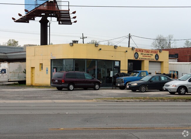
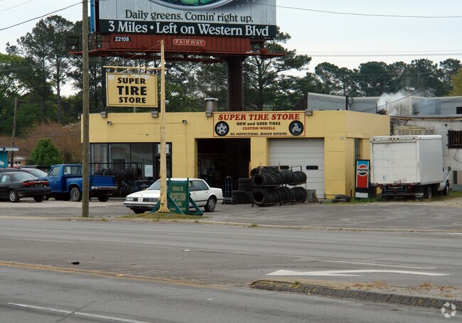
401 Chaney Ave
026194
Bailey Family Ventures Llc
Laundromat
TR B BAILEY FAMILY VENTURES COMBINE W/419-20;419-17 & PT 419-18
X
Onslow
3720437600J
North Carolina
2025
0.88 AC
2025
North Carolina Southeast Area
001101
Other Market Areas
6,189 SF
Jacksonville, NC
DEMOGRAPHICS near 401 Chaney Ave
1 mile
3 mile
5 mile
2024 Total Population
5,426
36,447
76,751
2029 Population
5,773
38,185
80,601
Pop Growth 2024-2029
+ 6.40%
+ 4.77%
+ 5.02%
Average Age
36
32
32
2024 Total Households
2,248
12,838
27,675
HH Growth 2024-2029
+ 6.81%
+ 5.24%
+ 5.43%
Median Household Inc
$44,319
$48,700
$48,945
Avg Household Size
2.20
2.40
2.50
2024 Avg HH Vehicles
1.00
2.00
2.00
Median Home Value
$130,357
$158,792
$162,607
Median Year Built
1957
1979
1990
Nearby Places
Map Layers
Map Styles
 Street
 Aerial
Transit
 Traffic
 Biking
Places
Listings with unknown addresses are not visible on the map
- Restaurants
- Banks
- Shops
- Fitness
- Groceries
PUBLIC TRANSPORTATION
AIRPORT
Albert J Ellis
Drive
Walk
Distance
Albert J Ellis
28 min
14.4 mi
Coastal Carolina Regional
Drive
Walk
Distance
Coastal Carolina Regional
59 min
42.7 mi
Freight Ports
Port of Morehead City
Drive
Walk
Distance
Port of Morehead City
68 min
43.8 mi
Nearby Properties
Address
Land Use
TOTAL SIZE
Lot Size
Zoning
Address
Land Use
TOTAL SIZE
Lot Size
Zoning
244,010 SF
52.70 AC
CC
Address
Land Use
TOTAL SIZE
Lot Size
Zoning
11,192 SF
64.76 AC
OI
Address
Land Use
TOTAL SIZE
Lot Size
Zoning
164,207 SF
43.55 AC
OI
Address
Land Use
TOTAL SIZE
Lot Size
Zoning
189,717 SF
1.93 AC
DTB
Address
Land Use
TOTAL SIZE
Lot Size
Zoning
27,193 SF
20.13 AC
RMF-HD
Address
Land Use
TOTAL SIZE
Lot Size
Zoning
25,860 SF
13.10 AC
RMF-HD
Address
Land Use
TOTAL SIZE
Lot Size
Zoning
10,560 SF
42.87 AC
RSF-7
Address
Land Use
TOTAL SIZE
Lot Size
Zoning
50,600 SF
17 AC
CC
Address
Land Use
TOTAL SIZE
Lot Size
Zoning
38,147 SF
3.14 AC
DTB
Address
Land Use
TOTAL SIZE
Lot Size
Zoning
94,547 SF
6.37 AC
DTB
Address
Land Use
TOTAL SIZE
Lot Size
Zoning
2,951 SF
16.39 AC
RMF-HD
Address
Land Use
TOTAL SIZE
Lot Size
Zoning
24,882 SF
7.30 AC
RMF-HD
Address
Land Use
TOTAL SIZE
Lot Size
Zoning
211,186 SF
22.08 AC
CC
Address
Land Use
TOTAL SIZE
Lot Size
Zoning
204,711 SF
9.70 AC
CC
Address
Land Use
TOTAL SIZE
Lot Size
Zoning
16,248 SF
21.09 AC
RMF-HD
Address
Land Use
TOTAL SIZE
Lot Size
Zoning
94,263 SF
5.88 AC
DTB
Address
Land Use
TOTAL SIZE
Lot Size
Zoning
464 SF
458.49 AC
H-IN
Address
Land Use
TOTAL SIZE
Lot Size
Zoning
124,749 SF
16.31 AC
CC
Address
Land Use
TOTAL SIZE
Lot Size
Zoning
2,480 SF
11.59 AC
RMF-HD
Address
Land Use
TOTAL SIZE
Lot Size
Zoning
2,289 SF
7.22 AC
RMF-HD
Address
Land Use
TOTAL SIZE
Lot Size
Zoning
139,938 SF
13.87 AC
CC
Address
Land Use
TOTAL SIZE
Lot Size
Zoning
27,856 SF
20.11 AC
CC
Address
Land Use
TOTAL SIZE
Lot Size
Zoning
11,064 SF
17.85 AC
RMF-HD
Address
Land Use
TOTAL SIZE
Lot Size
Zoning
10,368 SF
23.17 AC
CC
Address
Land Use
TOTAL SIZE
Lot Size
Zoning
140,403 SF
15.78 AC
CC
Address
Land Use
TOTAL SIZE
Lot Size
Zoning
15,746 SF
27.64 AC
RSF-7
Address
Land Use
TOTAL SIZE
Lot Size
Zoning
828 SF
8.56 AC
RMF-HD
Address
Land Use
TOTAL SIZE
Lot Size
Zoning
130,374 SF
15.72 AC
CC
Address
Land Use
TOTAL SIZE
Lot Size
Zoning
7,008 SF
9.72 AC
RMF-HD
Address
Land Use
TOTAL SIZE
Lot Size
Zoning
18,312 SF
16.25 AC
IND
The World's #1 Commercial Real Estate Marketplace
Connect with us
© 2026 CoStar Group
The information above has been obtained from sources believed reliable. While we do not doubt its accuracy we have not verified it and make no guarantee, warranty or representation about it. It is your responsibility to independently confirm its accuracy and completeness. Any projections, opinions, assumptions, or estimates used are for example only and do not represent the current or future performance of the property. The value of this transaction to you depends on tax and other factors which should be evaluated by your tax, financial, and legal advisors. You and your advisors should conduct a careful, independent investigation of the property to determine to your satisfaction the suitability of the property for your needs.