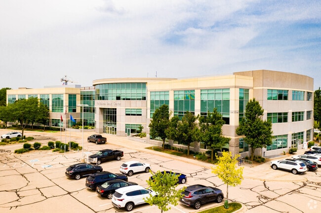
Property Record
401 Charmany Dr, Madison, WI 53719


Current Lease Availabilities
Property Detail
401 Charmany Dr
0709-302-0201-8
UNIVERSITY RESEARCH PARK, UNIVERSITY OF WISCONSIN - MADISON, SECOND ADDITION, LO T 37. ALSO PART OF LOT 38, DESC AS FOL BEG MOST WLY COR SD LOT 38, TH N 34 DEG 5 4 MIN 19 SEC E 179.11 FT, TH S 00 DEG 14 MIN 46 SEC E 54.87 FT, TH S 34 DEG 54 M IN 19 S
Commercialnec
Dane
RMX
Wisconsin
B and X Area of moderate flood hazard, usually the area between the limits of the 100-year and 500-year floods.
37
2025
7.04 AC
2025
Near West Madison
000408
Milwaukee/Madison
102,551 SF
Madison, WI
NEARBY LISTINGS FOR SALE OR LEASE
DEMOGRAPHICS near 401 Charmany Dr
1 mile
3 mile
5 mile
2025 Total Population
8,182
89,897
258,245
2030 Population
8,673
93,348
274,263
Pop Growth 2025-2030
+ 6.00%
+ 3.84%
+ 6.20%
Average Age
47
40
37
2025 Total Households
3,796
41,334
113,064
HH Growth 2025-2030
+ 6.56%
+ 4.23%
+ 6.61%
Median Household Inc
$79,501
$79,686
$74,487
Avg Household Size
2.00
2.10
2.10
2025 Avg HH Vehicles
2.00
2.00
1.00
Median Home Value
$427,054
$430,518
$444,422
Median Year Built
1972
1976
1990
Nearby Places
Map Layers
Map Styles
 Street
 Aerial
Layers
 Traffic
 Biking
Places
Listings with unknown addresses are not visible on the map
- Restaurants
- Banks
- Shops
- Fitness
- Groceries
Nearby Properties
Address
Land Use
TOTAL SIZE
Lot Size
Zoning
Address
Land Use
TOTAL SIZE
Lot Size
Zoning
408,311 SF
9.26 AC
SE
Address
Land Use
TOTAL SIZE
Lot Size
Zoning
501,997 SF
26.90 AC
SE
Address
Land Use
TOTAL SIZE
Lot Size
Zoning
393,708 SF
2.89 AC
PD
Address
Land Use
TOTAL SIZE
Lot Size
Zoning
530,774 SF
37.40 AC
RMX
Address
Land Use
TOTAL SIZE
Lot Size
Zoning
526,685 SF
23.94 AC
SR-V2
Address
Land Use
TOTAL SIZE
Lot Size
Zoning
156,908 SF
23.87 AC
SE
Address
Land Use
TOTAL SIZE
Lot Size
Zoning
143,360 SF
10.27 AC
SEC
Address
Land Use
TOTAL SIZE
Lot Size
Zoning
235,052 SF
7.34 AC
WP-28
Address
Land Use
TOTAL SIZE
Lot Size
Zoning
262,260 SF
6.28 AC
TR-U2
Address
Land Use
TOTAL SIZE
Lot Size
Zoning
317,128 SF
10.14 AC
PD
Address
Land Use
TOTAL SIZE
Lot Size
Zoning
557,272 SF
28.49 AC
PD
Address
Land Use
TOTAL SIZE
Lot Size
Zoning
217,664 SF
1.43 AC
TE
Address
Land Use
TOTAL SIZE
Lot Size
Zoning
350,550 SF
6.17 AC
TR-U2
Address
Land Use
TOTAL SIZE
Lot Size
Zoning
51,205 SF
9.32 AC
SE
Address
Land Use
TOTAL SIZE
Lot Size
Zoning
167,555 SF
2.98 AC
TR-U2
Address
Land Use
TOTAL SIZE
Lot Size
Zoning
2.91 AC
CC-T
Address
Land Use
TOTAL SIZE
Lot Size
Zoning
237,562 SF
4.59 AC
PD
Address
Land Use
TOTAL SIZE
Lot Size
Zoning
248,319 SF
8.47 AC
PD
Address
Land Use
TOTAL SIZE
Lot Size
Zoning
13.98 AC
Address
Land Use
TOTAL SIZE
Lot Size
Zoning
217,919 SF
11.97 AC
PD
Address
Land Use
TOTAL SIZE
Lot Size
Zoning
295,772 SF
7.35 AC
PD
Address
Land Use
TOTAL SIZE
Lot Size
Zoning
360,223 SF
PD
Address
Land Use
TOTAL SIZE
Lot Size
Zoning
170,606 SF
1.08 AC
PD
Address
Land Use
TOTAL SIZE
Lot Size
Zoning
13.87 AC
Address
Land Use
TOTAL SIZE
Lot Size
Zoning
180,250 SF
0.58 AC
PD
Address
Land Use
TOTAL SIZE
Lot Size
Zoning
37,909 SF
10.27 AC
SEC
Address
Land Use
TOTAL SIZE
Lot Size
Zoning
234,796 SF
9.04 AC
PD
Address
Land Use
TOTAL SIZE
Lot Size
Zoning
181,766 SF
1.84 AC
PD
Address
Land Use
TOTAL SIZE
Lot Size
Zoning
178,542 SF
10.32 AC
PD
Address
Land Use
TOTAL SIZE
Lot Size
Zoning
151,983 SF
8.50 AC
SR-V2
The World's #1 Commercial Real Estate Marketplace
Connect with us
© 2026 CoStar Group
The information above has been obtained from sources believed reliable. While we do not doubt its accuracy we have not verified it and make no guarantee, warranty or representation about it. It is your responsibility to independently confirm its accuracy and completeness. Any projections, opinions, assumptions, or estimates used are for example only and do not represent the current or future performance of the property. The value of this transaction to you depends on tax and other factors which should be evaluated by your tax, financial, and legal advisors. You and your advisors should conduct a careful, independent investigation of the property to determine to your satisfaction the suitability of the property for your needs.