Property Record
401 Deats Rd, Dickinson, TX 77539
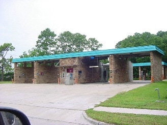


Property Detail
401 Deats Rd
Houston-Pasadena-The Woodlands, TX
GAY BUICK GMC SUB (2016) ABST 19, BLOCK 1, LOT 2, ACRES 1.14
3549-0001-0002-000
Galveston
Commercialnec
Texas
AE The base floodplain where base flood elevations are provided. AE Zones are now used on new format FIRMs instead of A1-A30 Zones.
2
2024
1.14 AC
2025
Southeast Outlier
720800
Houston
2,264 SF
NEARBY LISTINGS FOR SALE OR LEASE
DEMOGRAPHICS near 401 Deats Rd
1 mile
3 mile
5 mile
2025 Total Population
8,236
49,186
124,175
2030 Population
8,535
50,771
127,826
Pop Growth 2025-2030
+ 3.63%
+ 3.22%
+ 2.94%
Average Age
37
37
37
2025 Total Households
3,000
17,094
43,531
HH Growth 2025-2030
+ 3.73%
+ 3.08%
+ 2.88%
Median Household Inc
$93,735
$101,156
$105,818
Avg Household Size
2.70
2.80
2.80
2025 Avg HH Vehicles
2.00
2.00
2.00
Median Home Value
$283,188
$294,826
$316,416
Median Year Built
1987
2002
2000
Nearby Places
Map Layers
Map Styles
 Street
 Aerial
Layers
 Traffic
 Biking
Places
Listings with unknown addresses are not visible on the map
- Restaurants
- Banks
- Shops
- Fitness
- Groceries
PUBLIC TRANSPORTATION
AIRPORT
William P Hobby
Drive
Walk
Distance
William P Hobby
31 min
19.3 mi
Freight Ports
Port of Galveston
Drive
Walk
Distance
Port of Galveston
29 min
21.1 mi
Nearby Properties
Address
Land Use
TOTAL SIZE
Lot Size
Zoning
Address
Land Use
TOTAL SIZE
Lot Size
Zoning
417,305 SF
32.01 AC
Address
Land Use
TOTAL SIZE
Lot Size
Zoning
450,000 SF
27.82 AC
Address
Land Use
TOTAL SIZE
Lot Size
Zoning
355,987 SF
46.99 AC
Address
Land Use
TOTAL SIZE
Lot Size
Zoning
366,500 SF
21.88 AC
Address
Land Use
TOTAL SIZE
Lot Size
Zoning
340,198 SF
18.69 AC
Address
Land Use
TOTAL SIZE
Lot Size
Zoning
165,000 SF
50.03 AC
Address
Land Use
TOTAL SIZE
Lot Size
Zoning
17,784 SF
37.39 AC
Address
Land Use
TOTAL SIZE
Lot Size
Zoning
175,000 SF
29.99 AC
Address
Land Use
TOTAL SIZE
Lot Size
Zoning
200,240 SF
14.73 AC
Address
Land Use
TOTAL SIZE
Lot Size
Zoning
12.95 AC
Address
Land Use
TOTAL SIZE
Lot Size
Zoning
226,300 SF
12.11 AC
Address
Land Use
TOTAL SIZE
Lot Size
Zoning
260,343 SF
14.46 AC
Address
Land Use
TOTAL SIZE
Lot Size
Zoning
219,355 SF
10.24 AC
Address
Land Use
TOTAL SIZE
Lot Size
Zoning
182,020 SF
100.72 AC
Address
Land Use
TOTAL SIZE
Lot Size
Zoning
70,660 SF
27.08 AC
Address
Land Use
TOTAL SIZE
Lot Size
Zoning
113,400 SF
21.05 AC
Address
Land Use
TOTAL SIZE
Lot Size
Zoning
218,231 SF
22.45 AC
Address
Land Use
TOTAL SIZE
Lot Size
Zoning
156,188 SF
7.07 AC
Address
Land Use
TOTAL SIZE
Lot Size
Zoning
92,716 SF
11.35 AC
Address
Land Use
TOTAL SIZE
Lot Size
Zoning
176,681 SF
13.43 AC
Address
Land Use
TOTAL SIZE
Lot Size
Zoning
90,273 SF
8.76 AC
Address
Land Use
TOTAL SIZE
Lot Size
Zoning
129,600 SF
25.69 AC
Address
Land Use
TOTAL SIZE
Lot Size
Zoning
102,938 SF
9.22 AC
Address
Land Use
TOTAL SIZE
Lot Size
Zoning
78,092 SF
10.65 AC
Address
Land Use
TOTAL SIZE
Lot Size
Zoning
47,656 SF
Address
Land Use
TOTAL SIZE
Lot Size
Zoning
60,400 SF
17.89 AC
Address
Land Use
TOTAL SIZE
Lot Size
Zoning
87,528 SF
7.89 AC
Address
Land Use
TOTAL SIZE
Lot Size
Zoning
177,387 SF
13.49 AC
Address
Land Use
TOTAL SIZE
Lot Size
Zoning
218,231 SF
12.65 AC
Address
Land Use
TOTAL SIZE
Lot Size
Zoning
81,548 SF
4.75 AC
The World's #1 Commercial Real Estate Marketplace
Connect with us
© 2026 CoStar Group
The information above has been obtained from sources believed reliable. While we do not doubt its accuracy we have not verified it and make no guarantee, warranty or representation about it. It is your responsibility to independently confirm its accuracy and completeness. Any projections, opinions, assumptions, or estimates used are for example only and do not represent the current or future performance of the property. The value of this transaction to you depends on tax and other factors which should be evaluated by your tax, financial, and legal advisors. You and your advisors should conduct a careful, independent investigation of the property to determine to your satisfaction the suitability of the property for your needs.