Property Record
401 Dowlin St N, Champlin, MN 55316
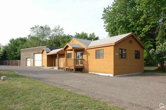


Property Detail
401 Dowlin St N
Minneapolis-St. Paul-Bloomington, MN-WI
LOT 001 BLOCK 003 A AUDITORS SUBD. NO. 015 NELY 200 FT OF SWLY 300 FT OF NWLY 206 5/10 FT FRONT AND REAR EX STATE HWY IRREGULAR
19-120-21-31-0017
HENNEPIN
Commercialacreage
Minnesota
B and X Area of moderate flood hazard, usually the area between the limits of the 100-year and 500-year floods.
1
0
0.55 AC
2025
Maple Grove
026906
Minneapolis/St Paul
NEARBY LISTINGS FOR SALE OR LEASE
DEMOGRAPHICS near 401 Dowlin St N
1 mile
3 mile
5 mile
2025 Total Population
9,258
62,237
147,204
2030 Population
9,400
63,246
150,113
Pop Growth 2025-2030
+ 1.53%
+ 1.62%
+ 1.98%
Average Age
43
41
40
2025 Total Households
4,113
24,437
54,902
HH Growth 2025-2030
+ 1.70%
+ 1.76%
+ 2.04%
Median Household Inc
$76,518
$91,828
$99,746
Avg Household Size
2.20
2.50
2.60
2025 Avg HH Vehicles
2.00
2.00
2.00
Median Home Value
$346,014
$342,902
$351,184
Median Year Built
1982
1983
1987
Nearby Places
Map Layers
Map Styles
 Street
 Aerial
Layers
 Traffic
 Biking
Places
Listings with unknown addresses are not visible on the map
- Restaurants
- Banks
- Shops
- Fitness
- Groceries
PUBLIC TRANSPORTATION
COMMUTER RAIL
Anoka Station (Northstar Corridor - Northstar Commuter Rail)
Drive
Walk
Distance
Anoka Station (Northstar Corridor - Northstar Commuter Rail)
7 min
3.0 mi
Coon Rapids-Riverdale Station (Northstar Corridor - Northstar Commuter Rail)
Drive
Walk
Distance
Coon Rapids-Riverdale Station (Northstar Corridor - Northstar Commuter Rail)
10 min
4.7 mi
AIRPORT
Minneapolis-St Paul International/Wold-Chamberlain
Drive
Walk
Distance
Minneapolis-St Paul International/Wold-Chamberlain
45 min
31.6 mi
Nearby Properties
Address
Land Use
TOTAL SIZE
Lot Size
Zoning
Address
Land Use
TOTAL SIZE
Lot Size
Zoning
517,619 SF
3.85 AC
Address
Land Use
TOTAL SIZE
Lot Size
Zoning
468,099 SF
5.73 AC
MSMU
Address
Land Use
TOTAL SIZE
Lot Size
Zoning
3.80 AC
Address
Land Use
TOTAL SIZE
Lot Size
Zoning
2,400 SF
72.45 AC
Address
Land Use
TOTAL SIZE
Lot Size
Zoning
319,826 SF
37.97 AC
Address
Land Use
TOTAL SIZE
Lot Size
Zoning
1 SF
4.51 AC
Address
Land Use
TOTAL SIZE
Lot Size
Zoning
5,110 SF
38.62 AC
Address
Land Use
TOTAL SIZE
Lot Size
Zoning
Address
Land Use
TOTAL SIZE
Lot Size
Zoning
122,816 SF
27.84 AC
Address
Land Use
TOTAL SIZE
Lot Size
Zoning
4.99 AC
Address
Land Use
TOTAL SIZE
Lot Size
Zoning
363,449 SF
82.99 AC
R-1
Address
Land Use
TOTAL SIZE
Lot Size
Zoning
382,508 SF
Address
Land Use
TOTAL SIZE
Lot Size
Zoning
129,060 SF
10.21 AC
Address
Land Use
TOTAL SIZE
Lot Size
Zoning
1 SF
4.73 AC
Address
Land Use
TOTAL SIZE
Lot Size
Zoning
Address
Land Use
TOTAL SIZE
Lot Size
Zoning
13.63 AC
Address
Land Use
TOTAL SIZE
Lot Size
Zoning
Address
Land Use
TOTAL SIZE
Lot Size
Zoning
339,424 SF
25.42 AC
M-1
Address
Land Use
TOTAL SIZE
Lot Size
Zoning
13.44 AC
Address
Land Use
TOTAL SIZE
Lot Size
Zoning
159,335 SF
0.13 AC
Address
Land Use
TOTAL SIZE
Lot Size
Zoning
16.31 AC
Address
Land Use
TOTAL SIZE
Lot Size
Zoning
14.27 AC
Address
Land Use
TOTAL SIZE
Lot Size
Zoning
298,148 SF
17.70 AC
M-1
Address
Land Use
TOTAL SIZE
Lot Size
Zoning
114,281 SF
3.19 AC
PRD-4
Address
Land Use
TOTAL SIZE
Lot Size
Zoning
319,664 SF
19.62 AC
M-1
Address
Land Use
TOTAL SIZE
Lot Size
Zoning
11.55 AC
Address
Land Use
TOTAL SIZE
Lot Size
Zoning
329,545 SF
17.75 AC
M-1
Address
Land Use
TOTAL SIZE
Lot Size
Zoning
300,547 SF
19.21 AC
Address
Land Use
TOTAL SIZE
Lot Size
Zoning
118,208 SF
Address
Land Use
TOTAL SIZE
Lot Size
Zoning
The World's #1 Commercial Real Estate Marketplace
Connect with us
© 2026 CoStar Group
The information above has been obtained from sources believed reliable. While we do not doubt its accuracy we have not verified it and make no guarantee, warranty or representation about it. It is your responsibility to independently confirm its accuracy and completeness. Any projections, opinions, assumptions, or estimates used are for example only and do not represent the current or future performance of the property. The value of this transaction to you depends on tax and other factors which should be evaluated by your tax, financial, and legal advisors. You and your advisors should conduct a careful, independent investigation of the property to determine to your satisfaction the suitability of the property for your needs.