Property Record
401 E 5Th St, Pinconning, MI 48650
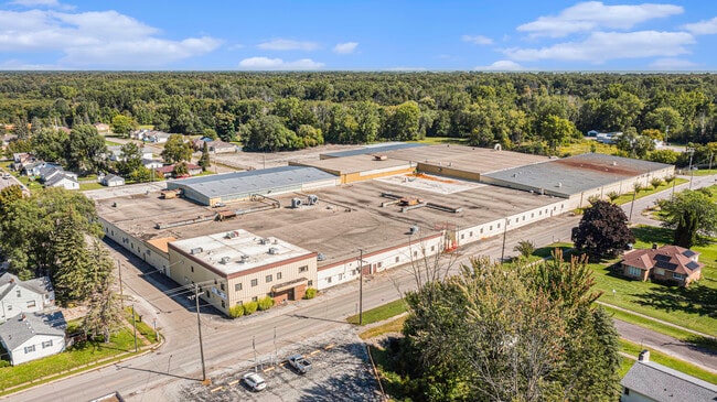

This Property Is For Sale
Property Detail
401 E 5Th St
09-180-P10-003-001-00
COM AT NE COR OF 5TH & JENNINGS STS TH E M OR L 920.92 FT TH N 754 FT TH N 61DEG 47MIN 10SEC W TO N
Heavymanufacturing
Bay
AE The base floodplain where base flood elevations are provided. AE Zones are now used on new format FIRMs instead of A1-A30 Zones.
Michigan
2025
13.40 AC
2025
Midland/Flint
286300
Other Market Areas
229,779 SF
Bay City, MI
NEARBY LISTINGS FOR SALE OR LEASE
-
-
View all Pinconning listings for sale on LoopNet.com
DEMOGRAPHICS near 401 E 5Th St
1 mile
3 mile
5 mile
2025 Total Population
1,737
3,134
5,297
2030 Population
1,743
3,151
5,309
Pop Growth 2025-2030
+ 0.35%
+ 0.54%
+ 0.23%
Average Age
44
44
44
2025 Total Households
751
1,345
2,266
HH Growth 2025-2030
+ 0.27%
+ 0.52%
+ 0.18%
Median Household Inc
$69,178
$68,634
$63,824
Avg Household Size
2.30
2.30
2.30
2025 Avg HH Vehicles
2.00
2.00
2.00
Median Home Value
$136,181
$138,675
$143,891
Median Year Built
1966
1968
1969
Nearby Places
Map Layers
Map Styles
 Street
 Aerial
Layers
 Traffic
 Biking
Places
Listings with unknown addresses are not visible on the map
- Restaurants
- Banks
- Shops
- Fitness
- Groceries
PUBLIC TRANSPORTATION
AIRPORT
MBS International
Drive
Walk
Distance
MBS International
44 min
30.2 mi
Freight Ports
Port of Toledo
Drive
Walk
Distance
Port of Toledo
203 min
174.7 mi
Nearby Properties
Address
Land Use
TOTAL SIZE
Lot Size
Zoning
Address
Land Use
TOTAL SIZE
Lot Size
Zoning
34,160 SF
7.39 AC
Address
Land Use
TOTAL SIZE
Lot Size
Zoning
34,160 SF
46.08 AC
Address
Land Use
TOTAL SIZE
Lot Size
Zoning
79,920 SF
33.75 AC
LI
Address
Land Use
TOTAL SIZE
Lot Size
Zoning
45,764 SF
5.47 AC
Address
Land Use
TOTAL SIZE
Lot Size
Zoning
41,248 SF
13.03 AC
Address
Land Use
TOTAL SIZE
Lot Size
Zoning
32,412 SF
4.25 AC
LI
Address
Land Use
TOTAL SIZE
Lot Size
Zoning
20,000 SF
4.82 AC
Address
Land Use
TOTAL SIZE
Lot Size
Zoning
32,256 SF
3 AC
Address
Land Use
TOTAL SIZE
Lot Size
Zoning
Address
Land Use
TOTAL SIZE
Lot Size
Zoning
58,130 SF
2.43 AC
Address
Land Use
TOTAL SIZE
Lot Size
Zoning
158.54 AC
Address
Land Use
TOTAL SIZE
Lot Size
Zoning
2,014 SF
116.46 AC
Address
Land Use
TOTAL SIZE
Lot Size
Zoning
18,832 SF
2.82 AC
R-2
Address
Land Use
TOTAL SIZE
Lot Size
Zoning
70,420 SF
10.80 AC
LI
Address
Land Use
TOTAL SIZE
Lot Size
Zoning
7,621 SF
1.19 AC
Address
Land Use
TOTAL SIZE
Lot Size
Zoning
68,855 SF
3.15 AC
Address
Land Use
TOTAL SIZE
Lot Size
Zoning
3,888 SF
0.93 AC
Address
Land Use
TOTAL SIZE
Lot Size
Zoning
117.28 AC
Address
Land Use
TOTAL SIZE
Lot Size
Zoning
8,000 SF
5 AC
Address
Land Use
TOTAL SIZE
Lot Size
Zoning
156.28 AC
Address
Land Use
TOTAL SIZE
Lot Size
Zoning
11,200 SF
5 AC
Address
Land Use
TOTAL SIZE
Lot Size
Zoning
118.25 AC
Address
Land Use
TOTAL SIZE
Lot Size
Zoning
9,100 SF
1.27 AC
Address
Land Use
TOTAL SIZE
Lot Size
Zoning
101.33 AC
Address
Land Use
TOTAL SIZE
Lot Size
Zoning
11,296 SF
1.64 AC
Address
Land Use
TOTAL SIZE
Lot Size
Zoning
132 AC
TH N0?34'5
Address
Land Use
TOTAL SIZE
Lot Size
Zoning
3,134 SF
80 AC
Address
Land Use
TOTAL SIZE
Lot Size
Zoning
Address
Land Use
TOTAL SIZE
Lot Size
Zoning
10.43 AC
The World's #1 Commercial Real Estate Marketplace
Connect with us
© 2026 CoStar Group
The information above has been obtained from sources believed reliable. While we do not doubt its accuracy we have not verified it and make no guarantee, warranty or representation about it. It is your responsibility to independently confirm its accuracy and completeness. Any projections, opinions, assumptions, or estimates used are for example only and do not represent the current or future performance of the property. The value of this transaction to you depends on tax and other factors which should be evaluated by your tax, financial, and legal advisors. You and your advisors should conduct a careful, independent investigation of the property to determine to your satisfaction the suitability of the property for your needs.