Property Record
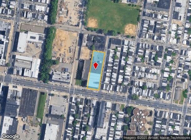
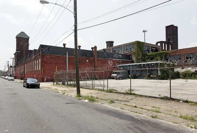
413 E Allegheny Ave, Philadelphia, PA 19134

NEARBY LISTINGS FOR SALE OR LEASE
Property Detail
413 E Allegheny Ave
Philadelphia-Camden-Wilmington, PA-NJ-DE-MD
Pomerantz & Co
884526200
1126 E TO NWC
Warehouse
Philadelphia
X
Pennsylvania
34007C0026F
142
2024
0.94 AC
2026
Kensington
017702
Philadelphia
72,308 SF
DEMOGRAPHICS near 413 E Allegheny Ave
1 Mile
3 Mile
5 Mile
2024 Total Population
57,516
397,207
984,191
2029 Population
56,046
387,668
959,586
Pop Growth 2024-2029
(2.56%)
(2.40%)
(2.50%)
Average Age
35
36
37
2024 Total Households
19,821
149,177
397,890
HH Growth 2024-2029
(2.79%)
(2.46%)
(2.68%)
Median Household Inc
$25,424
$37,877
$51,672
Avg Household Size
2.80
2.50
2.30
2024 Avg HH Vehicles
1.00
1.00
1.00
Median Home Value
$78,027
$152,792
$196,019
Median Year Built
1946
1947
1949
Nearby Places
Map Layers
Map Styles
 Street
 Aerial
- Restaurants
- Banks
- Shops
- Fitness
- Groceries
PUBLIC TRANSPORTATION
TRANSIT/SUBWAY
Somerset (Market-Frankford Line - Southeastern Pennsylvania Transportation Authority Rapid Transit (SEPTA Subway & Trolley))
DRIVE
WALK
Distance
Somerset (Market-Frankford Line - Southeastern Pennsylvania Transportation Authority Rapid Transit (SEPTA Subway & Trolley))
2 min
11 min
0.5 mi
Allegheny (MFL) (Market-Frankford Line - Southeastern Pennsylvania Transportation Authority Rapid Transit (SEPTA Subway & Trolley))
DRIVE
WALK
Distance
Allegheny (MFL) (Market-Frankford Line - Southeastern Pennsylvania Transportation Authority Rapid Transit (SEPTA Subway & Trolley))
2 min
11 min
0.6 mi
Huntingdon (Market-Frankford Line - Southeastern Pennsylvania Transportation Authority Rapid Transit (SEPTA Subway & Trolley))
DRIVE
WALK
Distance
Huntingdon (Market-Frankford Line - Southeastern Pennsylvania Transportation Authority Rapid Transit (SEPTA Subway & Trolley))
3 min
15 min
0.7 mi
COMMUTER RAIL
North Philadelphia (Broad Street Line - Southeastern Pennsylvania Transportation Authority Rapid Transit (SEPTA Subway & Trolley))
DRIVE
WALK
Distance
North Philadelphia (Broad Street Line - Southeastern Pennsylvania Transportation Authority Rapid Transit (SEPTA Subway & Trolley))
5 min
2.0 mi
North Philadelphia (R7 - Southeastern Pennsylvania Transportation Authority Regional Rail (SEPTA Regional Rail), R8 - Southeastern Pennsylvania Transportation Authority Regional Rail (SEPTA Regional Rail))
DRIVE
WALK
Distance
North Philadelphia (R7 - Southeastern Pennsylvania Transportation Authority Regional Rail (SEPTA Regional Rail), R8 - Southeastern Pennsylvania Transportation Authority Regional Rail (SEPTA Regional Rail))
6 min
2.1 mi
AIRPORT
Philadelphia International
DRIVE
WALK
Distance
Philadelphia International
27 min
15.2 mi
Trenton Mercer
DRIVE
WALK
Distance
Trenton Mercer
47 min
31.4 mi
Freight Ports
Port of Philadelphia
DRIVE
WALK
Distance
Port of Philadelphia
6 min
2.5 mi
Nearby Properties
Address
Land Use
TOTAL SIZE
Lot Size
Zoning
Address
Land Use
TOTAL SIZE
Lot Size
Zoning
880,950 SF
27.71 AC
SPENT
Address
Land Use
TOTAL SIZE
Lot Size
Zoning
1.88 AC
SPINS
Address
Land Use
TOTAL SIZE
Lot Size
Zoning
804,000 SF
4.29 AC
CMX3
Address
Land Use
TOTAL SIZE
Lot Size
Zoning
363,801 SF
2.59 AC
CMX4
Address
Land Use
TOTAL SIZE
Lot Size
Zoning
322,000 SF
7.44 AC
CMX3
Address
Land Use
TOTAL SIZE
Lot Size
Zoning
332,444 SF
1.32 AC
CMX3
Address
Land Use
TOTAL SIZE
Lot Size
Zoning
740,701 SF
47.70 AC
I2
Address
Land Use
TOTAL SIZE
Lot Size
Zoning
461,286 SF
2.64 AC
CMX4
Address
Land Use
TOTAL SIZE
Lot Size
Zoning
500,875 SF
4.31 AC
RM1
Address
Land Use
TOTAL SIZE
Lot Size
Zoning
380,040 SF
1.22 AC
ICMX
Address
Land Use
TOTAL SIZE
Lot Size
Zoning
285,615 SF
1.46 AC
SPINS
Address
Land Use
TOTAL SIZE
Lot Size
Zoning
254,947 SF
1.73 AC
CMX4
Address
Land Use
TOTAL SIZE
Lot Size
Zoning
96,574 SF
2.42 AC
RM2
Address
Land Use
TOTAL SIZE
Lot Size
Zoning
458,556 SF
1.57 AC
CMX3
Address
Land Use
TOTAL SIZE
Lot Size
Zoning
485,616 SF
8.96 AC
CMX3
Address
Land Use
TOTAL SIZE
Lot Size
Zoning
242,655 SF
3.29 AC
CMX3
Address
Land Use
TOTAL SIZE
Lot Size
Zoning
3,590 SF
50 AC
SPPOA
Address
Land Use
TOTAL SIZE
Lot Size
Zoning
324,477 SF
1.99 AC
CMX4
Address
Land Use
TOTAL SIZE
Lot Size
Zoning
293,510 SF
7.03 AC
SPINS
Address
Land Use
TOTAL SIZE
Lot Size
Zoning
17,886 SF
80 AC
SPPOA
Address
Land Use
TOTAL SIZE
Lot Size
Zoning
390,773 SF
2.86 AC
CMX3
Address
Land Use
TOTAL SIZE
Lot Size
Zoning
164,412 SF
4.44 AC
SPINS
Address
Land Use
TOTAL SIZE
Lot Size
Zoning
577,800 SF
6.98 AC
CMX3
Address
Land Use
TOTAL SIZE
Lot Size
Zoning
234,684 SF
0.45 AC
CMX4
Address
Land Use
TOTAL SIZE
Lot Size
Zoning
829,504 SF
4.77 AC
SPINS
Address
Land Use
TOTAL SIZE
Lot Size
Zoning
458,556 SF
1.39 AC
CMX3
Address
Land Use
TOTAL SIZE
Lot Size
Zoning
128,164 SF
6.82 AC
SPINS
Address
Land Use
TOTAL SIZE
Lot Size
Zoning
218,960 SF
1.55 AC
RM2
Address
Land Use
TOTAL SIZE
Lot Size
Zoning
425,000 SF
2.08 AC
SPINS
Address
Land Use
TOTAL SIZE
Lot Size
Zoning
163,400 SF
1.20 AC
CMX3
The World's #1 Commercial Real Estate Marketplace
Connect with us
© 2025 CoStar Group
The information above has been obtained from sources believed reliable. While we do not doubt its accuracy we have not verified it and make no guarantee, warranty or representation about it. It is your responsibility to independently confirm its accuracy and completeness. Any projections, opinions, assumptions, or estimates used are for example only and do not represent the current or future performance of the property. The value of this transaction to you depends on tax and other factors which should be evaluated by your tax, financial, and legal advisors. You and your advisors should conduct a careful, independent investigation of the property to determine to your satisfaction the suitability of the property for your needs.