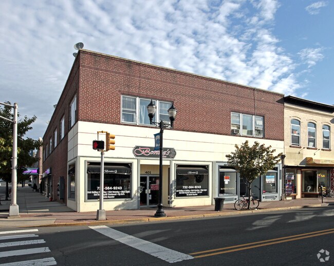
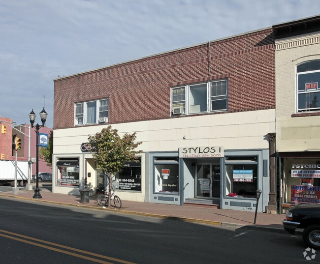
Property Record
401 E Main St, Bound Brook, NJ 08805

Property Detail
401 E Main St
Lakewood-New Brunswick, NJ
Somerset
04-00012-0000-00009
New Jersey
Retailwithmorethanonenonretailuse
9
B2
0.12 AC
2024
Route 287 West
2025
Northern New Jersey
051100
NEARBY LISTINGS FOR SALE OR LEASE
DEMOGRAPHICS near 401 E Main St
1 mile
3 mile
5 mile
2024 Total Population
16,083
67,460
189,580
2029 Population
16,556
69,940
197,147
Pop Growth 2024-2029
+ 2.94%
+ 3.68%
+ 3.99%
Average Age
39
41
41
2024 Total Households
5,802
24,501
67,984
HH Growth 2024-2029
+ 3.29%
+ 3.89%
+ 4.25%
Median Household Inc
$93,796
$122,804
$121,095
Avg Household Size
2.70
2.70
2.70
2024 Avg HH Vehicles
2.00
2.00
2.00
Median Home Value
$410,570
$463,104
$470,798
Median Year Built
1959
1971
1970
Nearby Places
Map Layers
Map Styles
 Street
 Aerial
Transit
 Traffic
 Biking
Places
Listings with unknown addresses are not visible on the map
- Restaurants
- Banks
- Shops
- Fitness
- Groceries
PUBLIC TRANSPORTATION
TRANSIT/SUBWAY
Bound Brook (Raritan Valley Line - NJ Transit Commuter Rail (NJ Transit))
Drive
Walk
Distance
Bound Brook (Raritan Valley Line - NJ Transit Commuter Rail (NJ Transit))
1 min
2 min
0.1 mi
COMMUTER RAIL
Bound Brook (Raritan Valley Line - NJ Transit Commuter Rail (NJ Transit))
Drive
Walk
Distance
Bound Brook (Raritan Valley Line - NJ Transit Commuter Rail (NJ Transit))
1 min
2 min
0.1 mi
Bridgewater (Raritan Valley Line - NJ Transit Commuter Rail (NJ Transit))
Drive
Walk
Distance
Bridgewater (Raritan Valley Line - NJ Transit Commuter Rail (NJ Transit))
4 min
1.3 mi
AIRPORT
Newark Liberty International
Drive
Walk
Distance
Newark Liberty International
40 min
27.3 mi
Trenton Mercer
Drive
Walk
Distance
Trenton Mercer
56 min
34.2 mi
LaGuardia
Drive
Walk
Distance
LaGuardia
75 min
49.9 mi
Freight Ports
New York Container Terminal
Drive
Walk
Distance
New York Container Terminal
37 min
27.7 mi
Nearby Properties
Address
Land Use
TOTAL SIZE
Lot Size
Zoning
Address
Land Use
TOTAL SIZE
Lot Size
Zoning
31.49 AC
LI5
Address
Land Use
TOTAL SIZE
Lot Size
Zoning
6,625 SF
22.51 AC
B-I
Address
Land Use
TOTAL SIZE
Lot Size
Zoning
70.22 AC
B-I
Address
Land Use
TOTAL SIZE
Lot Size
Zoning
17.01 AC
B-I
Address
Land Use
TOTAL SIZE
Lot Size
Zoning
19.46 AC
B-I
Address
Land Use
TOTAL SIZE
Lot Size
Zoning
64.99 AC
LI5
Address
Land Use
TOTAL SIZE
Lot Size
Zoning
39.10 AC
C3
Address
Land Use
TOTAL SIZE
Lot Size
Zoning
31.50 AC
B-I
Address
Land Use
TOTAL SIZE
Lot Size
Zoning
22.36 AC
PAC
Address
Land Use
TOTAL SIZE
Lot Size
Zoning
2,450 SF
26.84 AC
B-I
Address
Land Use
TOTAL SIZE
Lot Size
Zoning
22.75 AC
LC
Address
Land Use
TOTAL SIZE
Lot Size
Zoning
21.60 AC
LI5
Address
Land Use
TOTAL SIZE
Lot Size
Zoning
310,200 SF
26.23 AC
B-I
Address
Land Use
TOTAL SIZE
Lot Size
Zoning
32.92 AC
B-I
Address
Land Use
TOTAL SIZE
Lot Size
Zoning
Address
Land Use
TOTAL SIZE
Lot Size
Zoning
163,776 SF
44.53 AC
LI5
Address
Land Use
TOTAL SIZE
Lot Size
Zoning
24.34 AC
IND
Address
Land Use
TOTAL SIZE
Lot Size
Zoning
82.79 AC
M2
Address
Land Use
TOTAL SIZE
Lot Size
Zoning
2,488 SF
16.46 AC
PAC
Address
Land Use
TOTAL SIZE
Lot Size
Zoning
26.53 AC
B-I
Address
Land Use
TOTAL SIZE
Lot Size
Zoning
230,022 SF
15.48 AC
LI5
Address
Land Use
TOTAL SIZE
Lot Size
Zoning
4.05 AC
Address
Land Use
TOTAL SIZE
Lot Size
Zoning
13.38 AC
B2
Address
Land Use
TOTAL SIZE
Lot Size
Zoning
277,731 SF
17.91 AC
LI5
Address
Land Use
TOTAL SIZE
Lot Size
Zoning
309,212 SF
20.98 AC
B-I
Address
Land Use
TOTAL SIZE
Lot Size
Zoning
224,360 SF
17.65 AC
B-I
Address
Land Use
TOTAL SIZE
Lot Size
Zoning
237,360 SF
14.48 AC
B-I
Address
Land Use
TOTAL SIZE
Lot Size
Zoning
19.90 AC
IND
Address
Land Use
TOTAL SIZE
Lot Size
Zoning
19.63 AC
B-I
Address
Land Use
TOTAL SIZE
Lot Size
Zoning
237,580 SF
22 AC
B-I
The World's #1 Commercial Real Estate Marketplace
Connect with us
© 2026 CoStar Group
The information above has been obtained from sources believed reliable. While we do not doubt its accuracy we have not verified it and make no guarantee, warranty or representation about it. It is your responsibility to independently confirm its accuracy and completeness. Any projections, opinions, assumptions, or estimates used are for example only and do not represent the current or future performance of the property. The value of this transaction to you depends on tax and other factors which should be evaluated by your tax, financial, and legal advisors. You and your advisors should conduct a careful, independent investigation of the property to determine to your satisfaction the suitability of the property for your needs.