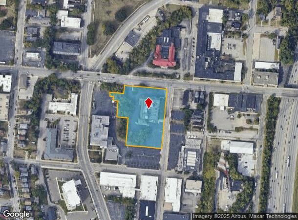
Property Record
401 E Mcmillan St, Cincinnati, OH 45206


NEARBY LISTINGS FOR SALE OR LEASE
Property Detail
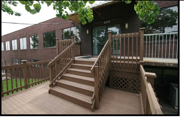
401 E Mcmillan St
068-0001-0175
Irwins
Charitableorganization
MCMILLAN ST 370.25 X 265 IRR WM F IRWIN PARS 175-176-184 TH 198-204 TH 218-306 TH 309-320-321-322 CONS
X
Hamilton
39061C0219E
Ohio
2024
2.24 AC
2024
Clifton/Midtown
026700
Cincinnati/Dayton
22,207 SF
Cincinnati, OH-KY-IN
DEMOGRAPHICS near 401 E Mcmillan St
1 Mile
3 Mile
5 Mile
2024 Total Population
27,796
152,016
334,677
2029 Population
28,089
154,476
337,838
Pop Growth 2024-2029
+ 1.05%
+ 1.62%
+ 0.94%
Average Age
31
36
37
2024 Total Households
10,830
68,813
149,028
HH Growth 2024-2029
+ 1.29%
+ 1.76%
+ 0.94%
Median Household Inc
$34,380
$49,631
$49,078
Avg Household Size
1.90
1.90
2.10
2024 Avg HH Vehicles
1.00
1.00
1.00
Median Home Value
$251,402
$253,167
$220,454
Median Year Built
1951
1949
1949
Nearby Places
Map Layers
Map Styles
 Street
 Aerial
- Restaurants
- Banks
- Shops
- Fitness
- Groceries
PUBLIC TRANSPORTATION
COMMUTER RAIL
Cincinnati Union Terminal (Cardinal - Amtrak)
DRIVE
WALK
Distance
Cincinnati Union Terminal (Cardinal - Amtrak)
10 min
4.3 mi
AIRPORT
Cincinnati/Northern Kentucky International
DRIVE
WALK
Distance
Cincinnati/Northern Kentucky International
31 min
16.3 mi
Freight Ports
Port of Toledo
DRIVE
WALK
Distance
Port of Toledo
242 min
203.3 mi
Nearby Properties
Address
Land Use
TOTAL SIZE
Lot Size
Zoning
Address
Land Use
TOTAL SIZE
Lot Size
Zoning
77.73 AC
IR
Address
Land Use
TOTAL SIZE
Lot Size
Zoning
6.35 AC
IR
Address
Land Use
TOTAL SIZE
Lot Size
Zoning
39.99 AC
MG
Address
Land Use
TOTAL SIZE
Lot Size
Zoning
11.82 AC
Address
Land Use
TOTAL SIZE
Lot Size
Zoning
19.36 AC
Address
Land Use
TOTAL SIZE
Lot Size
Zoning
17.10 AC
DD
Address
Land Use
TOTAL SIZE
Lot Size
Zoning
1.97 AC
DD
Address
Land Use
TOTAL SIZE
Lot Size
Zoning
62.10 AC
Address
Land Use
TOTAL SIZE
Lot Size
Zoning
11.41 AC
IR
Address
Land Use
TOTAL SIZE
Lot Size
Zoning
22.45 AC
Address
Land Use
TOTAL SIZE
Lot Size
Zoning
13.80 AC
Address
Land Use
TOTAL SIZE
Lot Size
Zoning
2.60 AC
Address
Land Use
TOTAL SIZE
Lot Size
Zoning
9.55 AC
Address
Land Use
TOTAL SIZE
Lot Size
Zoning
3.09 AC
Address
Land Use
TOTAL SIZE
Lot Size
Zoning
2.80 AC
IR
Address
Land Use
TOTAL SIZE
Lot Size
Zoning
3.40 AC
IR
Address
Land Use
TOTAL SIZE
Lot Size
Zoning
89,500 SF
0.58 AC
Address
Land Use
TOTAL SIZE
Lot Size
Zoning
Address
Land Use
TOTAL SIZE
Lot Size
Zoning
290,233 SF
Address
Land Use
TOTAL SIZE
Lot Size
Zoning
3.51 AC
DD
Address
Land Use
TOTAL SIZE
Lot Size
Zoning
Address
Land Use
TOTAL SIZE
Lot Size
Zoning
153,312 SF
4 AC
Address
Land Use
TOTAL SIZE
Lot Size
Zoning
9.14 AC
Address
Land Use
TOTAL SIZE
Lot Size
Zoning
11.68 AC
Address
Land Use
TOTAL SIZE
Lot Size
Zoning
298,611 SF
Address
Land Use
TOTAL SIZE
Lot Size
Zoning
7.14 AC
Address
Land Use
TOTAL SIZE
Lot Size
Zoning
256,000 SF
Address
Land Use
TOTAL SIZE
Lot Size
Zoning
1.95 AC
Address
Land Use
TOTAL SIZE
Lot Size
Zoning
Address
Land Use
TOTAL SIZE
Lot Size
Zoning
263,300 SF
1.74 AC
The World's #1 Commercial Real Estate Marketplace
Connect with us
© 2025 CoStar Group
The information above has been obtained from sources believed reliable. While we do not doubt its accuracy we have not verified it and make no guarantee, warranty or representation about it. It is your responsibility to independently confirm its accuracy and completeness. Any projections, opinions, assumptions, or estimates used are for example only and do not represent the current or future performance of the property. The value of this transaction to you depends on tax and other factors which should be evaluated by your tax, financial, and legal advisors. You and your advisors should conduct a careful, independent investigation of the property to determine to your satisfaction the suitability of the property for your needs.