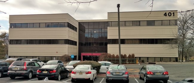
Property Record
401 Hamburg Tpke, Wayne, NJ 07470
This Property Is For Sale
NEARBY LISTINGS FOR SALE OR LEASE
Property Detail
401 Hamburg Tpke
New York-Jersey City-White Plains, NY-NJ
Wayne Hills Office Center
14-02901-0000-00101-0000-C0301
ADDITIONAL LOTS: C0302
Officecondo
Passaic
X
New Jersey
34031C0204G
101
2024
0.04 AC
2025
Passaic Rt 46/23
246101
Northern New Jersey
DEMOGRAPHICS near 401 Hamburg Tpke
1 Mile
3 Mile
5 Mile
2024 Total Population
8,761
119,116
354,246
2029 Population
8,655
116,144
345,532
Pop Growth 2024-2029
(1.21%)
(2.50%)
(2.46%)
Average Age
42
40
40
2024 Total Households
3,296
39,648
119,205
HH Growth 2024-2029
(1.27%)
(2.55%)
(2.56%)
Median Household Inc
$105,255
$88,457
$85,120
Avg Household Size
2.30
2.90
2.90
2024 Avg HH Vehicles
2.00
2.00
2.00
Median Home Value
$501,472
$490,499
$483,872
Median Year Built
1982
1961
1957
Nearby Places
- Restaurants
- Banks
- Shops
- Fitness
- Groceries
PUBLIC TRANSPORTATION
COMMUTER RAIL
Paterson (Main/Port Jervis Line - NJ Transit Commuter Rail (NJ Transit))
DRIVE
WALK
Distance
Paterson (Main/Port Jervis Line - NJ Transit Commuter Rail (NJ Transit))
7 min
4.0 mi
Hawthorne (Main/Port Jervis Line - NJ Transit Commuter Rail (NJ Transit))
DRIVE
WALK
Distance
Hawthorne (Main/Port Jervis Line - NJ Transit Commuter Rail (NJ Transit))
8 min
4.2 mi
AIRPORT
Newark Liberty International
DRIVE
WALK
Distance
Newark Liberty International
32 min
24.6 mi
LaGuardia
DRIVE
WALK
Distance
LaGuardia
43 min
27.8 mi
Westchester County
DRIVE
WALK
Distance
Westchester County
64 min
43.5 mi
Freight Ports
Port Newark Container Terminal
DRIVE
WALK
Distance
Port Newark Container Terminal
37 min
23.1 mi
Nearby Properties
Address
Land Use
TOTAL SIZE
Lot Size
Zoning
Address
Land Use
TOTAL SIZE
Lot Size
Zoning
45,000 SF
124.04 AC
R-A
Address
Land Use
TOTAL SIZE
Lot Size
Zoning
61.98 AC
Address
Land Use
TOTAL SIZE
Lot Size
Zoning
84.08 AC
Address
Land Use
TOTAL SIZE
Lot Size
Zoning
Address
Land Use
TOTAL SIZE
Lot Size
Zoning
19.20 AC
Address
Land Use
TOTAL SIZE
Lot Size
Zoning
90.48 AC
Address
Land Use
TOTAL SIZE
Lot Size
Zoning
Address
Land Use
TOTAL SIZE
Lot Size
Zoning
342,518 SF
31.80 AC
IP
Address
Land Use
TOTAL SIZE
Lot Size
Zoning
1,482 SF
55.66 AC
R-B
Address
Land Use
TOTAL SIZE
Lot Size
Zoning
27.25 AC
Address
Land Use
TOTAL SIZE
Lot Size
Zoning
220,994 SF
16.48 AC
Address
Land Use
TOTAL SIZE
Lot Size
Zoning
192,252 SF
5 AC
Address
Land Use
TOTAL SIZE
Lot Size
Zoning
183,072 SF
5.50 AC
Address
Land Use
TOTAL SIZE
Lot Size
Zoning
269,236 SF
10 AC
Address
Land Use
TOTAL SIZE
Lot Size
Zoning
21.82 AC
Address
Land Use
TOTAL SIZE
Lot Size
Zoning
11.89 AC
Address
Land Use
TOTAL SIZE
Lot Size
Zoning
3.58 AC
Address
Land Use
TOTAL SIZE
Lot Size
Zoning
186,299 SF
2.16 AC
R-A
Address
Land Use
TOTAL SIZE
Lot Size
Zoning
Address
Land Use
TOTAL SIZE
Lot Size
Zoning
145,949 SF
50 AC
Address
Land Use
TOTAL SIZE
Lot Size
Zoning
277,661 SF
50.20 AC
Address
Land Use
TOTAL SIZE
Lot Size
Zoning
Address
Land Use
TOTAL SIZE
Lot Size
Zoning
134,923 SF
7.16 AC
Address
Land Use
TOTAL SIZE
Lot Size
Zoning
63,460 SF
10.72 AC
Address
Land Use
TOTAL SIZE
Lot Size
Zoning
259,919 SF
48.14 AC
Address
Land Use
TOTAL SIZE
Lot Size
Zoning
3.73 AC
B-2
Address
Land Use
TOTAL SIZE
Lot Size
Zoning
10.31 AC
Address
Land Use
TOTAL SIZE
Lot Size
Zoning
25.80 AC
Address
Land Use
TOTAL SIZE
Lot Size
Zoning
13.61 AC
Address
Land Use
TOTAL SIZE
Lot Size
Zoning
84,845 SF
2.30 AC
B-2
The World's #1 Commercial Real Estate Marketplace
Connect with us
© 2025 CoStar Group
The information above has been obtained from sources believed reliable. While we do not doubt its accuracy we have not verified it and make no guarantee, warranty or representation about it. It is your responsibility to independently confirm its accuracy and completeness. Any projections, opinions, assumptions, or estimates used are for example only and do not represent the current or future performance of the property. The value of this transaction to you depends on tax and other factors which should be evaluated by your tax, financial, and legal advisors. You and your advisors should conduct a careful, independent investigation of the property to determine to your satisfaction the suitability of the property for your needs.