Property Record
401 Highway 62-82, Wolfforth, TX 79382
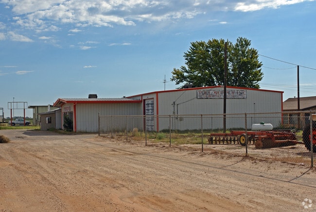

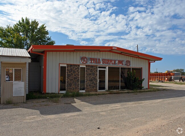
Property Detail
401 Highway 62-82
Lubbock, TX
BLK D6 SEC 31 AB 435 TR J1 & TR 9 & PT OF 7 & 8 CASEY IND ACS: 3.18 (LESS BLDG ONLY)
R106464
LUBBOCK
Commercialnec
Texas
AE The base floodplain where base flood elevations are provided. AE Zones are now used on new format FIRMs instead of A1-A30 Zones.
4009
2024
3.18 AC
2025
Outlying Lubbock County
010420
Lubbock
8,870 SF
NEARBY LISTINGS FOR SALE OR LEASE
DEMOGRAPHICS near 401 Highway 62-82
1 mile
3 mile
5 mile
2024 Total Population
4,128
17,862
56,510
2029 Population
4,482
19,178
59,796
Pop Growth 2024-2029
+ 8.58%
+ 7.37%
+ 5.81%
Average Age
38
35
37
2024 Total Households
1,511
6,223
21,580
HH Growth 2024-2029
+ 8.93%
+ 7.67%
+ 6.04%
Median Household Inc
$60,333
$87,288
$88,577
Avg Household Size
2.70
2.90
2.60
2024 Avg HH Vehicles
2.00
2.00
2.00
Median Home Value
$220,852
$259,919
$266,460
Median Year Built
1997
2008
2005
Nearby Places
Map Layers
Map Styles
 Street
 Aerial
Transit
 Traffic
 Biking
Places
Listings with unknown addresses are not visible on the map
- Restaurants
- Banks
- Shops
- Fitness
- Groceries
PUBLIC TRANSPORTATION
AIRPORT
Lubbock Preston Smith International
Drive
Walk
Distance
Lubbock Preston Smith International
35 min
21.8 mi
Nearby Properties
Address
Land Use
TOTAL SIZE
Lot Size
Zoning
Address
Land Use
TOTAL SIZE
Lot Size
Zoning
111,769 SF
25.03 AC
Address
Land Use
TOTAL SIZE
Lot Size
Zoning
187,409 SF
15.92 AC
Address
Land Use
TOTAL SIZE
Lot Size
Zoning
149,710 SF
10.57 AC
Address
Land Use
TOTAL SIZE
Lot Size
Zoning
217,245 SF
61.96 AC
Address
Land Use
TOTAL SIZE
Lot Size
Zoning
101,400 SF
5.49 AC
Address
Land Use
TOTAL SIZE
Lot Size
Zoning
31,135 SF
8.86 AC
Address
Land Use
TOTAL SIZE
Lot Size
Zoning
46,140 SF
1.61 AC
Address
Land Use
TOTAL SIZE
Lot Size
Zoning
109,728 SF
8.64 AC
Address
Land Use
TOTAL SIZE
Lot Size
Zoning
54.99 AC
Address
Land Use
TOTAL SIZE
Lot Size
Zoning
135.82 AC
Address
Land Use
TOTAL SIZE
Lot Size
Zoning
67,801 SF
7.50 AC
Address
Land Use
TOTAL SIZE
Lot Size
Zoning
30,992 SF
2.27 AC
Address
Land Use
TOTAL SIZE
Lot Size
Zoning
24,975 SF
3.82 AC
Address
Land Use
TOTAL SIZE
Lot Size
Zoning
72,066 SF
10 AC
Address
Land Use
TOTAL SIZE
Lot Size
Zoning
31,694 SF
10.68 AC
Address
Land Use
TOTAL SIZE
Lot Size
Zoning
26,039 SF
2.32 AC
Address
Land Use
TOTAL SIZE
Lot Size
Zoning
32.68 AC
Address
Land Use
TOTAL SIZE
Lot Size
Zoning
162,003 SF
19.24 AC
Address
Land Use
TOTAL SIZE
Lot Size
Zoning
85,490 SF
6.01 AC
Address
Land Use
TOTAL SIZE
Lot Size
Zoning
31.30 AC
Address
Land Use
TOTAL SIZE
Lot Size
Zoning
62,095 SF
3.57 AC
Address
Land Use
TOTAL SIZE
Lot Size
Zoning
7,519 SF
1.57 AC
Address
Land Use
TOTAL SIZE
Lot Size
Zoning
88,000 SF
6.04 AC
Address
Land Use
TOTAL SIZE
Lot Size
Zoning
79,614 SF
7.98 AC
Address
Land Use
TOTAL SIZE
Lot Size
Zoning
82,600 SF
7 AC
Address
Land Use
TOTAL SIZE
Lot Size
Zoning
16,072 SF
1.99 AC
Address
Land Use
TOTAL SIZE
Lot Size
Zoning
6,820 SF
1.97 AC
Address
Land Use
TOTAL SIZE
Lot Size
Zoning
25,068 SF
3.30 AC
Address
Land Use
TOTAL SIZE
Lot Size
Zoning
28,125 SF
5 AC
Address
Land Use
TOTAL SIZE
Lot Size
Zoning
5,743 SF
2.15 AC
The World's #1 Commercial Real Estate Marketplace
Connect with us
© 2026 CoStar Group
The information above has been obtained from sources believed reliable. While we do not doubt its accuracy we have not verified it and make no guarantee, warranty or representation about it. It is your responsibility to independently confirm its accuracy and completeness. Any projections, opinions, assumptions, or estimates used are for example only and do not represent the current or future performance of the property. The value of this transaction to you depends on tax and other factors which should be evaluated by your tax, financial, and legal advisors. You and your advisors should conduct a careful, independent investigation of the property to determine to your satisfaction the suitability of the property for your needs.