Property Record
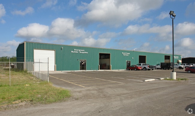
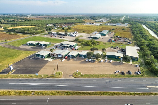
401 James Richard Closner Dr, La Feria, TX 78559

NEARBY LISTINGS FOR SALE OR LEASE
-
-
View all La Feria listings for lease on LoopNet.com
Property Detail
401 James Richard Closner Dr
862220-0110-000000
Solis Subdivision
Commercialnec
BLK 11 SOLIS SUBDIVISION 14.7 ACS OUT OF 18.50 ACRES OF W 20 ACRES (VOL 5 PG 20 MRCC)
X
Cameron
48061C0250F
Texas
2024
14.70 AC
2025
Outlying Cameron County
011907
Brownsville/Harlingen
30,090 SF
Brownsville-Harlingen, TX
DEMOGRAPHICS near 401 James Richard Closner Dr
1 Mile
3 Mile
5 Mile
2024 Total Population
1,292
13,527
39,717
2029 Population
1,349
14,167
41,619
Pop Growth 2024-2029
+ 4.41%
+ 4.73%
+ 4.79%
Average Age
38
37
36
2024 Total Households
424
4,419
12,360
HH Growth 2024-2029
+ 4.48%
+ 4.73%
+ 4.81%
Median Household Inc
$32,159
$38,665
$39,507
Avg Household Size
3.00
3.00
3.10
2024 Avg HH Vehicles
2.00
2.00
2.00
Median Home Value
$117,200
$92,155
$93,476
Median Year Built
1984
1989
1989
Nearby Places
Map Layers
Map Styles
 Street
 Aerial
- Restaurants
- Banks
- Shops
- Fitness
- Groceries
PUBLIC TRANSPORTATION
AIRPORT
Valley International
DRIVE
WALK
Distance
Valley International
23 min
15.4 mi
McAllen International
DRIVE
WALK
Distance
McAllen International
35 min
26.9 mi
Freight Ports
Port of Brownsville
DRIVE
WALK
Distance
Port of Brownsville
41 min
34.7 mi
SALE & LEASE HISTORY
LISTING DATE
SALE/LEASE

Aug 16, 2024
For Lease
Nearby Properties
Address
Land Use
TOTAL SIZE
Lot Size
Zoning
Address
Land Use
TOTAL SIZE
Lot Size
Zoning
635,188 SF
80.14 AC
Address
Land Use
TOTAL SIZE
Lot Size
Zoning
181,090 SF
53.36 AC
Address
Land Use
TOTAL SIZE
Lot Size
Zoning
110,910 SF
0.14 AC
A-C
Address
Land Use
TOTAL SIZE
Lot Size
Zoning
1 SF
4.92 AC
Address
Land Use
TOTAL SIZE
Lot Size
Zoning
1 SF
20 AC
Address
Land Use
TOTAL SIZE
Lot Size
Zoning
108,375 SF
1.82 AC
Address
Land Use
TOTAL SIZE
Lot Size
Zoning
40,170 SF
3.09 AC
Address
Land Use
TOTAL SIZE
Lot Size
Zoning
11,812 SF
8.55 AC
Address
Land Use
TOTAL SIZE
Lot Size
Zoning
38,592 SF
2.69 AC
Address
Land Use
TOTAL SIZE
Lot Size
Zoning
58,495 SF
24.73 AC
Address
Land Use
TOTAL SIZE
Lot Size
Zoning
113,125 SF
19.93 AC
Address
Land Use
TOTAL SIZE
Lot Size
Zoning
7,306 SF
14.50 AC
C
Address
Land Use
TOTAL SIZE
Lot Size
Zoning
7,920 SF
3.82 AC
CO
Address
Land Use
TOTAL SIZE
Lot Size
Zoning
6,058 SF
19.24 AC
C
Address
Land Use
TOTAL SIZE
Lot Size
Zoning
80,193 SF
6.46 AC
Address
Land Use
TOTAL SIZE
Lot Size
Zoning
4,251 SF
7.95 AC
C
Address
Land Use
TOTAL SIZE
Lot Size
Zoning
725 SF
3.21 AC
Address
Land Use
TOTAL SIZE
Lot Size
Zoning
14,274 SF
10 AC
C
Address
Land Use
TOTAL SIZE
Lot Size
Zoning
4,786 SF
2.57 AC
Address
Land Use
TOTAL SIZE
Lot Size
Zoning
89,239 SF
5.98 AC
Address
Land Use
TOTAL SIZE
Lot Size
Zoning
74,340 SF
4.06 AC
CO
Address
Land Use
TOTAL SIZE
Lot Size
Zoning
1 SF
27.82 AC
Address
Land Use
TOTAL SIZE
Lot Size
Zoning
17,695 SF
4.15 AC
C
Address
Land Use
TOTAL SIZE
Lot Size
Zoning
4,736 SF
1.20 AC
C
Address
Land Use
TOTAL SIZE
Lot Size
Zoning
17,167 SF
1.11 AC
Address
Land Use
TOTAL SIZE
Lot Size
Zoning
18,516 SF
2.55 AC
Address
Land Use
TOTAL SIZE
Lot Size
Zoning
118,852 SF
10.33 AC
Address
Land Use
TOTAL SIZE
Lot Size
Zoning
19,440 SF
3.17 AC
C
Address
Land Use
TOTAL SIZE
Lot Size
Zoning
11,941 SF
1.24 AC
Address
Land Use
TOTAL SIZE
Lot Size
Zoning
41,904 SF
2 AC
CO
The World's #1 Commercial Real Estate Marketplace
Connect with us
© 2025 CoStar Group
The information above has been obtained from sources believed reliable. While we do not doubt its accuracy we have not verified it and make no guarantee, warranty or representation about it. It is your responsibility to independently confirm its accuracy and completeness. Any projections, opinions, assumptions, or estimates used are for example only and do not represent the current or future performance of the property. The value of this transaction to you depends on tax and other factors which should be evaluated by your tax, financial, and legal advisors. You and your advisors should conduct a careful, independent investigation of the property to determine to your satisfaction the suitability of the property for your needs.